![](/images/other/stat-length.png)
![Tocht Stappen Godewaarsvelde - Mont des Cats - Photo](https://media.geolcdn.com/t/1900/400/f7eaba71-a3db-4c2a-8b5b-0dd16d92cd81.jpg&format=pjpeg&maxdim=2)
Mont des Cats
Greg813
Gebruiker
![Lengte](/images/other/stat-length.png)
Lengte
8,9 km
![Max. hoogte](https://static1.geolcdn.com/siteimages/upload/files/1508320355ic_sort_altitude_max_24dp.png)
Max. hoogte
169 m
![Positief hoogteverschil](https://static1.geolcdn.com/siteimages/upload/files/1508320355ic_sort_den_pos_24dp.png)
Positief hoogteverschil
189 m
![Km-Effort](/images/other/stat-length.png)
Km-Effort
11,4 km
![Min. hoogte](https://static1.geolcdn.com/siteimages/upload/files/1508320355ic_sort_altitude_min_24dp.png)
Min. hoogte
40 m
![Negatief hoogteverschil](https://static1.geolcdn.com/siteimages/upload/files/1508320355ic_sort_den_neg_24dp.png)
Negatief hoogteverschil
189 m
![Boucle](https://static1.geolcdn.com/siteimages/upload/files/16400158638029165_repeat_loop_refresh_sync_direction_icon.png)
Boucle
Ja
Datum van aanmaak :
2022-01-30 13:20:13.316
Laatste wijziging :
2022-02-13 17:52:52.042
![Stappen](https://static1.geolcdn.com/sitytour/trail-icons/101.png)
1h51
Moeilijkheid : Medium
![Scan deze QR-code om de tocht te openen in de SityTrail-applicatie](https://capi.geolives.com/qq0zvz2zws4bq2lad0pu/sitytour/trails/3069908/qr.png?size=200)
Gratisgps-wandelapplicatie
Over ons
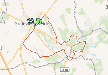
Tocht Stappen van 8,9 km beschikbaar op Hauts-de-France, Noorderdepartement, Godewaarsvelde. Deze tocht wordt voorgesteld door Greg813.
Beschrijving
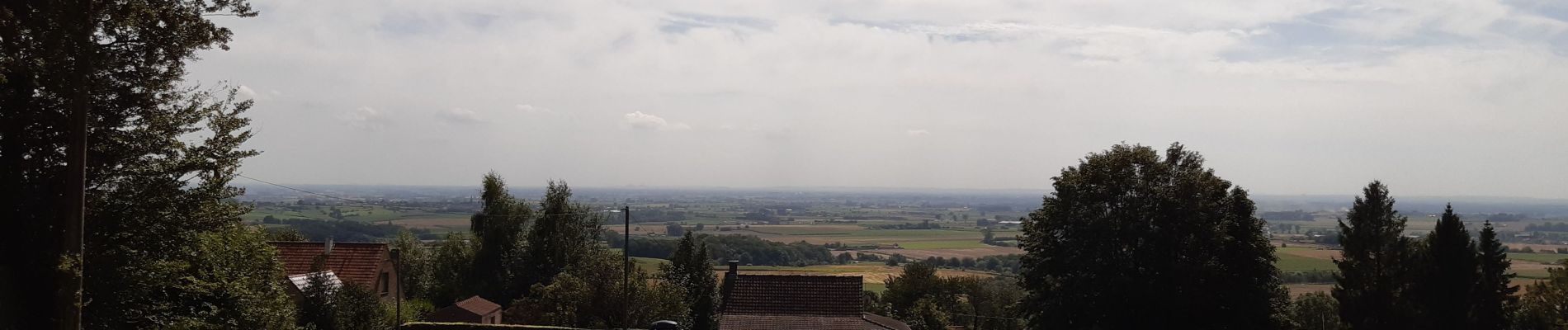
Randonnée avec Mettons le Monde en Marche depuis Godewaersvelde jusqu'au monastère du Mont des Cats.
Pour d'autres photos, voir le site de l'association :
https://mmm-rando.org/godewaersvelde-2022/
Plaatsbepaling
Land:
France
Regio :
Hauts-de-France
Departement/Provincie :
Noorderdepartement
Gemeente :
Godewaarsvelde
Locatie:
Unknown
Vertrek:(Dec)
Vertrek:(UTM)
474959 ; 5626819 (31U) N.
Opmerkingen
Wandeltochten in de omgeving
![Tocht Stappen Eke - Circuit du Klockhuis (Grande boucle) - Eecke - Photo](https://media.geolcdn.com/t/375/260/ext.jpg?maxdim=2&url=https%3A%2F%2Fservices.sitytrail.com%2FGeolivesWS%2FDownloadMedia.ashx%3FTrailID%3D191613%26Media%3D15253_3.jpg)
![Stappen Stappen](https://static1.geolcdn.com/sitytour/trail-icons/101.png)
Circuit du Klockhuis (Grande boucle) - Eecke
Stappen
Moeilijk
(2)
Eke,
Hauts-de-France,
Noorderdepartement,
France
![](/images/other/stat-length.png)
15 km | 16,5 km-effort
3h 45min
![](https://static1.geolcdn.com/siteimages/upload/files/16400158638029165_repeat_loop_refresh_sync_direction_icon.png)
Ja
![Tocht Stappen Berten - Autour du monastère - Godewaersvelde - Photo](https://media.geolcdn.com/t/375/260/ext.jpg?maxdim=2&url=https%3A%2F%2Fservices.sitytrail.com%2FGeolivesWS%2FDownloadMedia.ashx%3FTrailID%3D111182%26Media%3D6625_1.jpg)
![Stappen Stappen](https://static1.geolcdn.com/sitytour/trail-icons/101.png)
Autour du monastère - Godewaersvelde
Stappen
Moeilijk
(4)
Berten,
Hauts-de-France,
Noorderdepartement,
France
![](/images/other/stat-length.png)
11,8 km | 15,6 km-effort
3h 0min
![](https://static1.geolcdn.com/siteimages/upload/files/16400158638029165_repeat_loop_refresh_sync_direction_icon.png)
Ja
![Tocht Stappen Steenvoorde - Steenvorde Cassel 17 km - Photo](https://media.geolcdn.com/t/375/260/d605630e-39f4-49fe-bb3b-4650e249a5bb.jpg&format=jpg&maxdim=2)
![Stappen Stappen](https://static1.geolcdn.com/sitytour/trail-icons/101.png)
Steenvorde Cassel 17 km
Stappen
Zeer moeilijk
Steenvoorde,
Hauts-de-France,
Noorderdepartement,
France
![](/images/other/stat-length.png)
17 km | 19,9 km-effort
4h 31min
![](https://static1.geolcdn.com/siteimages/upload/files/16400158638029165_repeat_loop_refresh_sync_direction_icon.png)
Ja
![Tocht Stappen Boeschepe - Boeschepe - Photo](https://media.geolcdn.com/t/375/260/6c0906d5-5117-4202-927a-8c802fc11963.jpg&format=jpg&maxdim=2)
![Stappen Stappen](https://static1.geolcdn.com/sitytour/trail-icons/101.png)
Boeschepe
Stappen
Moeilijk
Boeschepe,
Hauts-de-France,
Noorderdepartement,
France
![](/images/other/stat-length.png)
10,6 km | 13 km-effort
2h 26min
![](https://static1.geolcdn.com/siteimages/upload/files/16400158638029165_repeat_loop_refresh_sync_direction_icon.png)
Neen
![Tocht Te voet Poperinge - Helleketelbos - Photo](https://media.geolcdn.com/t/375/260/0c8cf86c-730c-4042-b9e4-e508bb684d2d.jpeg&format=jpg&maxdim=2)
![Te voet Te voet](https://static1.geolcdn.com/sitytour/trail-icons/100.png)
Helleketelbos
Te voet
Gemakkelijk
Poperinge,
Vlaanderen,
West-Vlaanderen,
Belgium
![](/images/other/stat-length.png)
10,8 km | 12,5 km-effort
2h 49min
![](https://static1.geolcdn.com/siteimages/upload/files/16400158638029165_repeat_loop_refresh_sync_direction_icon.png)
Ja
![Tocht Stappen Steenvoorde - Steenvoorde 20 km - Photo](https://media.geolcdn.com/t/375/260/13209c13-682a-4334-a39b-be10d4a222e0.jpg&format=jpg&maxdim=2)
![Stappen Stappen](https://static1.geolcdn.com/sitytour/trail-icons/101.png)
Steenvoorde 20 km
Stappen
Medium
Steenvoorde,
Hauts-de-France,
Noorderdepartement,
France
![](/images/other/stat-length.png)
20 km | 24 km-effort
5h 44min
![](https://static1.geolcdn.com/siteimages/upload/files/16400158638029165_repeat_loop_refresh_sync_direction_icon.png)
Ja
![Tocht Stappen Boeschepe - Monts des Flandres CAF LILLE week-end des estaminets 2 - Photo](https://media.geolcdn.com/t/375/260/ext.jpg?maxdim=2&url=https%3A%2F%2Fservices.sitytrail.com%2FGeolivesWS%2FDownloadMedia.ashx%3FTrailID%3D541149%26Media%3Dfix__20160320134319.jpg)
![Stappen Stappen](https://static1.geolcdn.com/sitytour/trail-icons/101.png)
Monts des Flandres CAF LILLE week-end des estaminets 2
Stappen
Gemakkelijk
Boeschepe,
Hauts-de-France,
Noorderdepartement,
France
![](/images/other/stat-length.png)
21 km | 26 km-effort
5h 34min
![](https://static1.geolcdn.com/siteimages/upload/files/16400158638029165_repeat_loop_refresh_sync_direction_icon.png)
Ja
![Tocht Stappen Boeschepe - Week-end des estaminets CAF1 - Photo](https://media.geolcdn.com/t/375/260/ext.jpg?maxdim=2&url=https%3A%2F%2Fservices.sitytrail.com%2FGeolivesWS%2FDownloadMedia.ashx%3FTrailID%3D541147%26Media%3Dfix__20160319140516.jpg)
![Stappen Stappen](https://static1.geolcdn.com/sitytour/trail-icons/101.png)
Week-end des estaminets CAF1
Stappen
Gemakkelijk
Boeschepe,
Hauts-de-France,
Noorderdepartement,
France
![](/images/other/stat-length.png)
16,7 km | 21 km-effort
4h 32min
![](https://static1.geolcdn.com/siteimages/upload/files/16400158638029165_repeat_loop_refresh_sync_direction_icon.png)
Ja
![Tocht Stappen Berten - Balade des Katts - Photo](https://media.geolcdn.com/t/375/260/ext.jpg?maxdim=2&url=https%3A%2F%2Fservices.sitytrail.com%2FGeolivesWS%2FDownloadMedia.ashx%3FTrailID%3D202865%26Media%3De0bfffa3-cb95-4d1f-b064-23d12b092453.jpg)
![Stappen Stappen](https://static1.geolcdn.com/sitytour/trail-icons/101.png)
Balade des Katts
Stappen
Heel gemakkelijk
(3)
Berten,
Hauts-de-France,
Noorderdepartement,
France
![](/images/other/stat-length.png)
4,8 km | 6,4 km-effort
Onbekend
![](https://static1.geolcdn.com/siteimages/upload/files/16400158638029165_repeat_loop_refresh_sync_direction_icon.png)
Ja