![](/images/other/stat-length.png)
![Tocht Stappen Ascou - Crête de Pailhères & Sarrat des Chèvres- Pic de Tarbesou - Photo](https://media.geolcdn.com/t/1900/400/f1e23bb8-f7f7-4e4f-8a11-193e7164ca9f.jpg&format=pjpeg&maxdim=2)
Crête de Pailhères & Sarrat des Chèvres- Pic de Tarbesou
chrisgps
Gebruiker
![Lengte](/images/other/stat-length.png)
![Max. hoogte](https://static1.geolcdn.com/siteimages/upload/files/1508320355ic_sort_altitude_max_24dp.png)
![Positief hoogteverschil](https://static1.geolcdn.com/siteimages/upload/files/1508320355ic_sort_den_pos_24dp.png)
![Km-Effort](/images/other/stat-length.png)
![Min. hoogte](https://static1.geolcdn.com/siteimages/upload/files/1508320355ic_sort_altitude_min_24dp.png)
![Negatief hoogteverschil](https://static1.geolcdn.com/siteimages/upload/files/1508320355ic_sort_den_neg_24dp.png)
![Boucle](https://static1.geolcdn.com/siteimages/upload/files/16400158638029165_repeat_loop_refresh_sync_direction_icon.png)
![Stappen](https://static1.geolcdn.com/sitytour/trail-icons/101.png)
7h03
Moeilijkheid : Medium
![Scan deze QR-code om de tocht te openen in de SityTrail-applicatie](https://capi.geolives.com/qq0zvz2zws4bq2lad0pu/sitytour/trails/3066266/qr.png?size=200)
Gratisgps-wandelapplicatie
Over ons
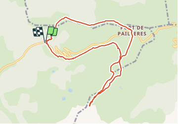
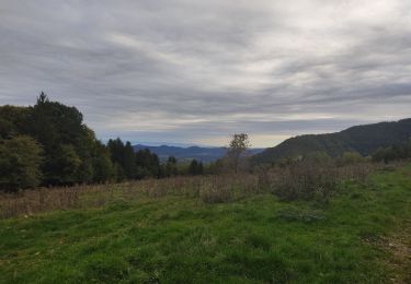
Tocht Stappen van 11,2 km beschikbaar op Occitanië, Ariège, Ascou. Deze tocht wordt voorgesteld door chrisgps.
Beschrijving
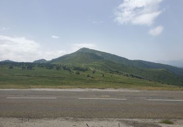
belle boucle dans le domaine skiable de Ascou-Pailhères.
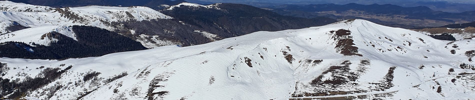
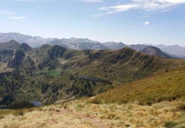
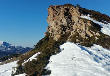
L'arrivée au Tarbesou était très glacé et très, très venté !! On n'a arrêté juste un tout petit peu avant le sommet. La redescente n'aurait pas été "drôle"!
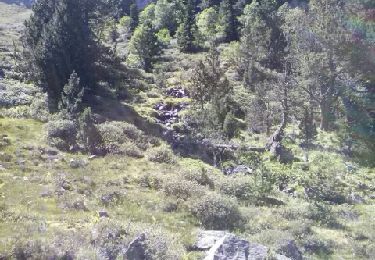
La descente par contre à côté du téléski a été "sportive" : beaucoup de neige ou verglacée ou croutée ou poudreuse.....!
Plaatsbepaling
Opmerkingen
Wandeltochten in de omgeving
![Tocht Stappen Mijanès - Les 3 étangs de rabassoles - Photo](https://media.geolcdn.com/t/375/260/807f0f4c-4bca-4248-a54c-7fda09f527fc.jpg&format=jpg&maxdim=2)
![Stappen Stappen](https://static1.geolcdn.com/sitytour/trail-icons/101.png)
Stappen
![](/images/other/stat-length.png)
![](https://static1.geolcdn.com/siteimages/upload/files/16400158638029165_repeat_loop_refresh_sync_direction_icon.png)
![Tocht Stappen Mijanès - col de l'Egue par les etgs de Balbone et les Rebassoles (10.2021) - Photo](https://media.geolcdn.com/t/375/260/3801f39a-142a-4689-b05d-eaf1eb8d4416.jpg&format=jpg&maxdim=2)
![Stappen Stappen](https://static1.geolcdn.com/sitytour/trail-icons/101.png)
Stappen
![](/images/other/stat-length.png)
![](https://static1.geolcdn.com/siteimages/upload/files/16400158638029165_repeat_loop_refresh_sync_direction_icon.png)
![Tocht Stappen La Fajolle - La forêt de La Fajolle - Photo](https://media.geolcdn.com/t/375/260/e6a5165b-43e1-4511-879f-4d2d537ffb0b.jpg&format=jpg&maxdim=2)
![Stappen Stappen](https://static1.geolcdn.com/sitytour/trail-icons/101.png)
Stappen
![](/images/other/stat-length.png)
![](https://static1.geolcdn.com/siteimages/upload/files/16400158638029165_repeat_loop_refresh_sync_direction_icon.png)
![Tocht Stappen Ascou - boucle autour du pic de tabersou et du pic de l ours - Photo](https://media.geolcdn.com/t/375/260/354f6e97-2a91-4ef1-9763-9e3f8f85838c.jpg&format=jpg&maxdim=2)
![Stappen Stappen](https://static1.geolcdn.com/sitytour/trail-icons/101.png)
Stappen
![](/images/other/stat-length.png)
![](https://static1.geolcdn.com/siteimages/upload/files/16400158638029165_repeat_loop_refresh_sync_direction_icon.png)
![Tocht Stappen Ascou - pic de Tarbésou - Photo](https://media.geolcdn.com/t/375/260/ext.jpg?maxdim=2&url=https%3A%2F%2Fstatic1.geolcdn.com%2Fsiteimages%2Fupload%2Ffiles%2F1553511878bg_sport_marche.png)
![Stappen Stappen](https://static1.geolcdn.com/sitytour/trail-icons/101.png)
Stappen
![](/images/other/stat-length.png)
![](https://static1.geolcdn.com/siteimages/upload/files/16400158638029165_repeat_loop_refresh_sync_direction_icon.png)
![Tocht Stappen Mijanès - etangs rabassoles - Photo](https://media.geolcdn.com/t/375/260/ext.jpg?maxdim=2&url=https%3A%2F%2Fservices.sitytrail.com%2FGeolivesWS%2FDownloadMedia.ashx%3FTrailID%3D148387%26Media%3D20120807155919.jpeg)
![Stappen Stappen](https://static1.geolcdn.com/sitytour/trail-icons/101.png)
Stappen
![](/images/other/stat-length.png)
![](https://static1.geolcdn.com/siteimages/upload/files/16400158638029165_repeat_loop_refresh_sync_direction_icon.png)
![Tocht Stappen Mijanès - l’Ourtiset - Photo](https://media.geolcdn.com/t/375/260/fa817c30-17da-41aa-8023-ac41831ec2c6.jpg&format=jpg&maxdim=2)
![Stappen Stappen](https://static1.geolcdn.com/sitytour/trail-icons/101.png)
![Tocht Stappen Ascou - 66 Pic de tarbesou - Photo](https://media.geolcdn.com/t/375/260/29a6dc62-8ef2-4e3a-bf35-f9721a120687.jpg&format=jpg&maxdim=2)
![Stappen Stappen](https://static1.geolcdn.com/sitytour/trail-icons/101.png)
Stappen
![](/images/other/stat-length.png)
![](https://static1.geolcdn.com/siteimages/upload/files/16400158638029165_repeat_loop_refresh_sync_direction_icon.png)
![Tocht Stappen Mérial - rando vallon d'Embournac - Photo](https://media.geolcdn.com/t/375/260/0e0b1618-0b53-4013-a937-5d57af7c4dc6.jpg&format=jpg&maxdim=2)
![Stappen Stappen](https://static1.geolcdn.com/sitytour/trail-icons/101.png)
Stappen
![](/images/other/stat-length.png)
![](https://static1.geolcdn.com/siteimages/upload/files/16400158638029165_repeat_loop_refresh_sync_direction_icon.png)