![](/images/other/stat-length.png)
![Tocht Te voet Cherier - Les Moulins Chérier - boucles autour du vieux bourg - Photo](https://media.geolcdn.com/t/1900/400/ext.pjpeg?maxdim=2&url=https%3A%2F%2Fmedia.geolcdn.com%2Ff%2F02a5a11d-56eb-4a94-af63-ae9a9466184f.jpg)
Les Moulins Chérier - boucles autour du vieux bourg
Jgar
Gebruiker
![Lengte](/images/other/stat-length.png)
![Max. hoogte](https://static1.geolcdn.com/siteimages/upload/files/1508320355ic_sort_altitude_max_24dp.png)
![Positief hoogteverschil](https://static1.geolcdn.com/siteimages/upload/files/1508320355ic_sort_den_pos_24dp.png)
![Km-Effort](/images/other/stat-length.png)
![Min. hoogte](https://static1.geolcdn.com/siteimages/upload/files/1508320355ic_sort_altitude_min_24dp.png)
![Negatief hoogteverschil](https://static1.geolcdn.com/siteimages/upload/files/1508320355ic_sort_den_neg_24dp.png)
![Boucle](https://static1.geolcdn.com/siteimages/upload/files/16400158638029165_repeat_loop_refresh_sync_direction_icon.png)
![Te voet](https://static1.geolcdn.com/sitytour/trail-icons/100.png)
2h50
Moeilijkheid : Gemakkelijk
![Scan deze QR-code om de tocht te openen in de SityTrail-applicatie](https://capi.geolives.com/qq0zvz2zws4bq2lad0pu/sitytour/trails/3064108/qr.png?size=200)
Gratisgps-wandelapplicatie
Over ons
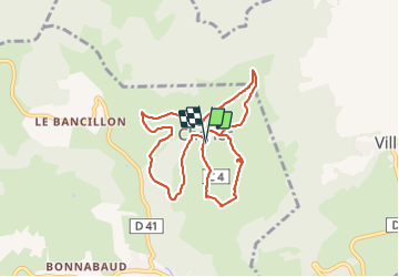
Tocht Te voet van 8,6 km beschikbaar op Auvergne-Rhône-Alpes, Loire, Cherier. Deze tocht wordt voorgesteld door Jgar.
Beschrijving
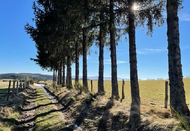
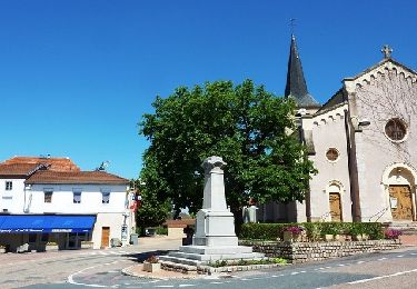
Parking à l'entrée ouest du bourg. Prendre la petite route de la Salette qui descend, monter à la chapelle et visiter les lieux. Redescendre et, rapidement, dans un virage, prendre la sente à droite qui rejoint une route vers le carrefour de Trêve Millot (monument de la marche Roanne-Thiers). Prendre à droite en descendant et à 200 m tourner de nouveau à droite entre une mare et un bâtiment agricole. Encore à 200 m, monter sur une sente qui passe entre des clôtures pour rejoindre le bourg en arrivant au cimetière. Passer devant la belle église romane et juste après l'atelier "Les Confitures du vieux Chérier", tourner à gauche. Passer devant le château d'eau puis descendre tout droit (panorama sur Pierre-sur-Haute, point culminant des Mts du Forez). Tourner à droite et traverser un petit bois de douglas. A 500 m, monter un chemin de droite encombré de ronces qui conduit à Roffat. Tourner à gauche sur la petite route et, 200 m plus loin, monter à droite, traverser le pré puis une autre route et tourner à droite sur un chemin qui descend au bourg. Vers la croix, tourner à gauche en direction des Roches de Ste Agathe (vol libre roannais). Poursuivre sur 800 m et traverser une barrière pour rejoindre un chemin à droite. A l'intersection, prendre de nouveau à droite pour rejoindre le bourg.
Plaatsbepaling
Opmerkingen
Wandeltochten in de omgeving
![Tocht sport Saint-Jean-Saint-Maurice-sur-Loire - Retour bis - Photo](https://media.geolcdn.com/t/375/260/ext.jpg?maxdim=2&url=https%3A%2F%2Fsecurestorage.geolives.com%2Fsitytour%2Ftrail-bg%2Fdefault.jpg)
sport
![](/images/other/stat-length.png)
![](https://static1.geolcdn.com/siteimages/upload/files/16400158638029165_repeat_loop_refresh_sync_direction_icon.png)
![Tocht Stappen Cherier - rocher de rochefort depuis la croix Trévingt - Photo](https://media.geolcdn.com/t/375/260/ext.jpg?maxdim=2&url=https%3A%2F%2Fmedia.geolcdn.com%2Ff%2Fdcc1659c-efdc-4c94-9e85-a848a823e0bd.jpg)
![Stappen Stappen](https://static1.geolcdn.com/sitytour/trail-icons/101.png)
Stappen
![](/images/other/stat-length.png)
![](https://static1.geolcdn.com/siteimages/upload/files/16400158638029165_repeat_loop_refresh_sync_direction_icon.png)
![Tocht Stappen - Randonnée sur les plateaux au dessus du village de Moulins -Chérier - Photo](https://media.geolcdn.com/t/375/260/ext.jpg?maxdim=2&url=https%3A%2F%2Fmedia.geolcdn.com%2Ff%2F328a50ea-b5e1-4410-88c7-07bd0b3b435c.jpg)
![Stappen Stappen](https://static1.geolcdn.com/sitytour/trail-icons/101.png)
Stappen
![](/images/other/stat-length.png)
![](https://static1.geolcdn.com/siteimages/upload/files/16400158638029165_repeat_loop_refresh_sync_direction_icon.png)
![Tocht Stappen Arcon - Arcon: Roche Corbière-Quatre Murs - Photo](https://media.geolcdn.com/t/375/260/ext.jpg?maxdim=2&url=https%3A%2F%2Fmedia.geolcdn.com%2Ff%2Ff084a593-c8ab-4485-bad9-4355d9e9f1a8.jpg)
![Stappen Stappen](https://static1.geolcdn.com/sitytour/trail-icons/101.png)
Stappen
![](/images/other/stat-length.png)
![](https://static1.geolcdn.com/siteimages/upload/files/16400158638029165_repeat_loop_refresh_sync_direction_icon.png)
![Tocht Stappen Cherier - rando à Moulin Charier - Photo](https://media.geolcdn.com/t/375/260/ext.jpg?maxdim=2&url=https%3A%2F%2Fmedia.geolcdn.com%2Ff%2F3886ddf7-94b0-4692-af5c-3d0753f12223.jpg)
![Stappen Stappen](https://static1.geolcdn.com/sitytour/trail-icons/101.png)
Stappen
![](/images/other/stat-length.png)
![](https://static1.geolcdn.com/siteimages/upload/files/16400158638029165_repeat_loop_refresh_sync_direction_icon.png)
![Tocht Stappen Villemontais - Villemontais : Chérier et Haut Ste-Agathe - Photo](https://media.geolcdn.com/t/375/260/ext.jpg?maxdim=2&url=https%3A%2F%2Fmedia.geolcdn.com%2Ff%2F43288f42-5353-465e-b07f-32492fc85c11.jpg)
![Stappen Stappen](https://static1.geolcdn.com/sitytour/trail-icons/101.png)
Stappen
![](/images/other/stat-length.png)
![](https://static1.geolcdn.com/siteimages/upload/files/16400158638029165_repeat_loop_refresh_sync_direction_icon.png)
![Tocht Stappen Cherier - Les Moulins Chérier : entre Les Faux et Montloup - Photo](https://media.geolcdn.com/t/375/260/ext.jpg?maxdim=2&url=https%3A%2F%2Fmedia.geolcdn.com%2Ff%2F35e95e0f-9bf0-4632-a277-b5de924d69b4.jpg)
![Stappen Stappen](https://static1.geolcdn.com/sitytour/trail-icons/101.png)
Stappen
![](/images/other/stat-length.png)
![](https://static1.geolcdn.com/siteimages/upload/files/16400158638029165_repeat_loop_refresh_sync_direction_icon.png)
![Tocht Stappen Saint-Alban-les-Eaux - Saint Alban les Eaux - Photo](https://media.geolcdn.com/t/375/260/ext.jpg?maxdim=2&url=https%3A%2F%2Fmedia.geolcdn.com%2Ff%2F7f2cea7f-360c-4463-89fa-eabea66e0bdf.JPG)
![Stappen Stappen](https://static1.geolcdn.com/sitytour/trail-icons/101.png)
Stappen
![](/images/other/stat-length.png)
![](https://static1.geolcdn.com/siteimages/upload/files/16400158638029165_repeat_loop_refresh_sync_direction_icon.png)
![Tocht Mountainbike Lentigny - Escapade dans les Gouttes de la Loire - Lentigny - Photo](https://media.geolcdn.com/t/375/260/ext.jpg?maxdim=2&url=https%3A%2F%2Fservices.sitytrail.com%2FGeolivesWS%2FDownloadMedia.ashx%3FTrailID%3D318105%26Media%3D17564_6.jpg)
![Mountainbike Mountainbike](https://static1.geolcdn.com/sitytour/trail-icons/202.png)
Mountainbike
![](/images/other/stat-length.png)
![](https://static1.geolcdn.com/siteimages/upload/files/16400158638029165_repeat_loop_refresh_sync_direction_icon.png)