Tocht Stappen Labets-Biscay - 03-2021-Camino 2 du 18.08.2021 - Photo
 bene_dictus77
bene_dictus77

Gebruiker

© OpenStreetMap contributors
Lengte
Lengte
22 km
Max. hoogte
Max. hoogte
288 m
Positief hoogteverschil
694 m
Km-Effort
Km-Effort  
31 km
Min. hoogte
Min. hoogte
38 m
Negatief hoogteverschil
573 m
Boucle
Boucle
Neen
Datum van aanmaak :
2021-08-18 07:36:18.0
Laatste wijziging :
2022-01-23 10:34:25.645

(0 Bericht)

Stappen
Stappen
5h04
Moeilijkheid : Medium

Scan deze QR-code om de tocht te openen in de SityTrail-applicatie

Gratisgps-wandelapplicatie

Logo SityTrail SityTrail

IGN / Geografische instituten

SityTrail uit de App Store downloaden SityTrail uit Google Play downloaden

Logo SityTrail SityTrail World

De wereld gaat voor u open

SityTrail uit de App Store downloaden SityTrail uit Google Play downloaden SityTrail op Huawei AppGallery downloaden

Over ons

Tocht Stappen van 22 km beschikbaar op Nieuw-Aquitanië, Pyrénées-Atlantiques, Labets-Biscay. Deze tocht wordt voorgesteld door bene_dictus77.

Beschrijving

Entre Labets et Ostabat

Hoogteprofiel

Plaatsbepaling

Land:
France
Regio :
Nieuw-Aquitanië
Departement/Provincie :
Pyrénées-Atlantiques
Gemeente :
Labets-Biscay
Locatie:
Unknown
Vertrek:(Dec)
Vertrek:(UTM)
657113 ; 4806570 (30T) N.

Wandeltochten in de omgeving

Tocht Paard Bergouey-Viellenave - Bergouey Viellenave - Came - Photo
Paard
tracegps

Paard

Medium
Bergouey-Viellenave, Nieuw-Aquitanië, Pyrénées-Atlantiques, France
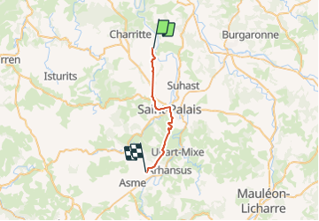
16,1 km | 21 km-effort
3h 0min
Neen


Sluiten
Mijn abonnementen