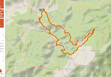
![](/images/other/stat-length.png)
![Tocht Stappen Collobrières - La Verne - Cèdres de Ragusse by DAL - Photo](https://media.geolcdn.com/t/1900/400/f7e1e88a-2b2e-4882-9eac-d0eeb8081eba.jpg&format=pjpeg&maxdim=2)
La Verne - Cèdres de Ragusse by DAL
dany83ynad
Gebruiker
![Lengte](/images/other/stat-length.png)
![Max. hoogte](https://static1.geolcdn.com/siteimages/upload/files/1508320355ic_sort_altitude_max_24dp.png)
![Positief hoogteverschil](https://static1.geolcdn.com/siteimages/upload/files/1508320355ic_sort_den_pos_24dp.png)
![Km-Effort](/images/other/stat-length.png)
![Min. hoogte](https://static1.geolcdn.com/siteimages/upload/files/1508320355ic_sort_altitude_min_24dp.png)
![Negatief hoogteverschil](https://static1.geolcdn.com/siteimages/upload/files/1508320355ic_sort_den_neg_24dp.png)
![Boucle](https://static1.geolcdn.com/siteimages/upload/files/16400158638029165_repeat_loop_refresh_sync_direction_icon.png)
![Stappen](https://static1.geolcdn.com/sitytour/trail-icons/101.png)
5h34
Moeilijkheid : Zeer moeilijk
![Scan deze QR-code om de tocht te openen in de SityTrail-applicatie](https://capi.geolives.com/qq0zvz2zws4bq2lad0pu/sitytour/trails/3053753/qr.png?size=200)
Gratisgps-wandelapplicatie
Over ons
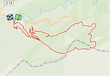
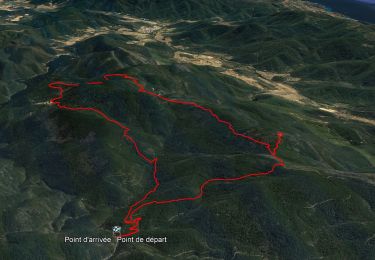
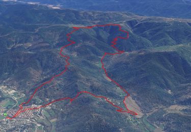
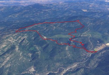
Tocht Stappen van 14,5 km beschikbaar op Provence-Alpes-Côte d'Azur, Var, Collobrières. Deze tocht wordt voorgesteld door dany83ynad.
Beschrijving
Départ parking de Ragusse passage à gué
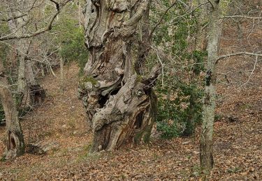
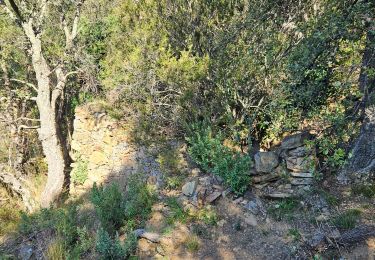
Montée par piste du barrage, puis du Bousquet pour sommet du Péra. Puis piste des Sivadières au sommet de l'Argentière (belle cabane pour barbecue). Descendre la piste des Sivadières jusqu'à la Chartreuse. Puis monter à gauche pour piste de Ragusse jusqu'à la forêt de cèdres sur chemin à gauche (rambarde à chevaux). Soit reprendre la piste qui serpente jusqu'au bas du vallon du Bousquet soit raccourci direct en descendant la forêt de Cèdres. Prendre le long du ruisseau du Bousquet jusqu'au gué sur la route. Parking à 300m.
Plaatsbepaling
Opmerkingen
Wandeltochten in de omgeving
![Tocht Stappen Collobrières - 10881733-Collobrières - La Verne - radar - Photo](https://media.geolcdn.com/t/375/260/da9d634a-9911-4550-a6f3-bff27c212c6d.jpg&format=jpg&maxdim=2)
![Stappen Stappen](https://static1.geolcdn.com/sitytour/trail-icons/101.png)
Stappen
![](/images/other/stat-length.png)
![](https://static1.geolcdn.com/siteimages/upload/files/16400158638029165_repeat_loop_refresh_sync_direction_icon.png)
![Tocht Stappen Collobrières - SityTrail - Collobriéres - Menhirs de Lambert - Photo](https://media.geolcdn.com/t/375/260/72b69c29-7d29-4189-adbb-316e95f51f98.jpg&format=jpg&maxdim=2)
![Stappen Stappen](https://static1.geolcdn.com/sitytour/trail-icons/101.png)
Stappen
![](/images/other/stat-length.png)
![](https://static1.geolcdn.com/siteimages/upload/files/16400158638029165_repeat_loop_refresh_sync_direction_icon.png)
![Tocht Stappen Bormes-les-Mimosas - SityTrail - 3043274 - bargeanxchartreuse-verne - Photo](https://media.geolcdn.com/t/375/260/3db88ff5-5d2e-4949-8a29-14c430fd8c8f.jpg&format=jpg&maxdim=2)
![Stappen Stappen](https://static1.geolcdn.com/sitytour/trail-icons/101.png)
Stappen
![](/images/other/stat-length.png)
![](https://static1.geolcdn.com/siteimages/upload/files/16400158638029165_repeat_loop_refresh_sync_direction_icon.png)
![Tocht Stappen Bormes-les-Mimosas - Chartreuse de la Verne - Photo](https://media.geolcdn.com/t/375/260/ext.jpg?maxdim=2&url=https%3A%2F%2Fservices.sitytrail.com%2FGeolivesWS%2FDownloadMedia.ashx%3FTrailID%3D898630%26Media%3Dfix__20170215102107.jpg)
![Stappen Stappen](https://static1.geolcdn.com/sitytour/trail-icons/101.png)
Stappen
![](/images/other/stat-length.png)
![](https://static1.geolcdn.com/siteimages/upload/files/16400158638029165_repeat_loop_refresh_sync_direction_icon.png)
![Tocht Mountainbike Collobrières - Collobrières par pistes - Photo](https://media.geolcdn.com/t/375/260/ext.jpg?maxdim=2&url=https%3A%2F%2Fstatic1.geolcdn.com%2Fsiteimages%2Fupload%2Ffiles%2F1524743154velo.jpg)
![Mountainbike Mountainbike](https://static1.geolcdn.com/sitytour/trail-icons/202.png)
Mountainbike
![](/images/other/stat-length.png)
![](https://static1.geolcdn.com/siteimages/upload/files/16400158638029165_repeat_loop_refresh_sync_direction_icon.png)
![Tocht Stappen Collobrières - Plateau Lambert 2 - Photo](https://media.geolcdn.com/t/375/260/ext.jpg?maxdim=2&url=https%3A%2F%2Fstatic1.geolcdn.com%2Fsiteimages%2Fupload%2Ffiles%2F1553511878bg_sport_marche.png)
![Stappen Stappen](https://static1.geolcdn.com/sitytour/trail-icons/101.png)
Stappen
![](/images/other/stat-length.png)
![](https://static1.geolcdn.com/siteimages/upload/files/16400158638029165_repeat_loop_refresh_sync_direction_icon.png)
![Tocht Stappen Collobrières - Verne - plateau Lambert - Photo](https://media.geolcdn.com/t/375/260/c4a3a8a8-b423-4008-8407-4394445c8024.jpg&format=jpg&maxdim=2)
![Stappen Stappen](https://static1.geolcdn.com/sitytour/trail-icons/101.png)
Stappen
![](/images/other/stat-length.png)
![](https://static1.geolcdn.com/siteimages/upload/files/16400158638029165_repeat_loop_refresh_sync_direction_icon.png)
![Tocht Stappen Bormes-les-Mimosas - Forêt du Dom - Photo](https://media.geolcdn.com/t/375/260/841c4ef1-7709-4d94-8f70-350221799c2e.jpg&format=jpg&maxdim=2)
![Stappen Stappen](https://static1.geolcdn.com/sitytour/trail-icons/101.png)
Stappen
![](/images/other/stat-length.png)
![](https://static1.geolcdn.com/siteimages/upload/files/16400158638029165_repeat_loop_refresh_sync_direction_icon.png)
![Tocht Stappen Collobrières - plateau Lambert en partant de Collobrieres - Photo](https://media.geolcdn.com/t/375/260/0201a1ab-7db2-4574-9d4b-cd6077f68d1f.png&format=jpg&maxdim=2)
![Stappen Stappen](https://static1.geolcdn.com/sitytour/trail-icons/101.png)
Stappen
![](/images/other/stat-length.png)
![](https://static1.geolcdn.com/siteimages/upload/files/16400158638029165_repeat_loop_refresh_sync_direction_icon.png)