![](/images/other/stat-length.png)
planche belles filles par auxelle haut
benoit747
Gebruiker
![Lengte](/images/other/stat-length.png)
Lengte
14,6 km
![Max. hoogte](https://static1.geolcdn.com/siteimages/upload/files/1508320355ic_sort_altitude_max_24dp.png)
Max. hoogte
1141 m
![Positief hoogteverschil](https://static1.geolcdn.com/siteimages/upload/files/1508320355ic_sort_den_pos_24dp.png)
Positief hoogteverschil
650 m
![Km-Effort](/images/other/stat-length.png)
Km-Effort
23 km
![Min. hoogte](https://static1.geolcdn.com/siteimages/upload/files/1508320355ic_sort_altitude_min_24dp.png)
Min. hoogte
568 m
![Negatief hoogteverschil](https://static1.geolcdn.com/siteimages/upload/files/1508320355ic_sort_den_neg_24dp.png)
Negatief hoogteverschil
656 m
![Boucle](https://static1.geolcdn.com/siteimages/upload/files/16400158638029165_repeat_loop_refresh_sync_direction_icon.png)
Boucle
Ja
Datum van aanmaak :
2014-12-10 00:00:00.0
Laatste wijziging :
2018-12-03 10:30:29.888
![Stappen](https://static1.geolcdn.com/sitytour/trail-icons/101.png)
4h55
Moeilijkheid : Medium
![Scan deze QR-code om de tocht te openen in de SityTrail-applicatie](https://capi.geolives.com/qq0zvz2zws4bq2lad0pu/sitytour/trails/305224/qr.png?size=200)
Gratisgps-wandelapplicatie
Over ons
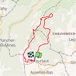
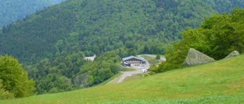
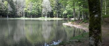
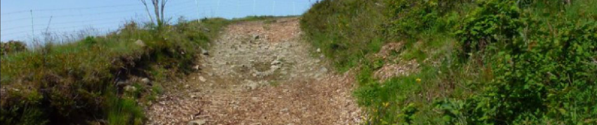
Tocht Stappen van 14,6 km beschikbaar op Bourgondië-Franche-Comté, Territoire-de-Belfort, Auxelles-Haut. Deze tocht wordt voorgesteld door benoit747.
Beschrijving
une rando avec du dénivelé.
Essayer de manger à l'étang des belles filles, le coin est très sympa.
la trace est issue d'un gps (et non tracée sur la carte)==> tous les chemins sont bons.
Plaatsbepaling
Land:
France
Regio :
Bourgondië-Franche-Comté
Departement/Provincie :
Territoire-de-Belfort
Gemeente :
Auxelles-Haut
Locatie:
Unknown
Vertrek:(Dec)
Vertrek:(UTM)
332977 ; 5290095 (32T) N.
Opmerkingen
Wandeltochten in de omgeving
![Tocht Stappen Lepuix - Le Tremontkopf - Photo](https://media.geolcdn.com/t/375/260/ext.jpg?maxdim=2&url=https%3A%2F%2Fservices.sitytrail.com%2FGeolivesWS%2FDownloadMedia.ashx%3FTrailID%3D109649%26Media%3D4290_1.jpg)
![Stappen Stappen](https://static1.geolcdn.com/sitytour/trail-icons/101.png)
Le Tremontkopf
Stappen
Medium
(1)
Lepuix,
Bourgondië-Franche-Comté,
Territoire-de-Belfort,
France
![](/images/other/stat-length.png)
9,1 km | 17,3 km-effort
3h 0min
![](https://static1.geolcdn.com/siteimages/upload/files/16400158638029165_repeat_loop_refresh_sync_direction_icon.png)
Ja
![Tocht Stappen Plancher-les-Mines - 2019-08-07 Balade Plancher des belles filles - Photo](https://media.geolcdn.com/t/375/260/66a371f6-1837-4f48-9b52-0abd1c8fe413.jpg&format=jpg&maxdim=2)
![Stappen Stappen](https://static1.geolcdn.com/sitytour/trail-icons/101.png)
2019-08-07 Balade Plancher des belles filles
Stappen
Heel gemakkelijk
Plancher-les-Mines,
Bourgondië-Franche-Comté,
Haute-Saône,
France
![](/images/other/stat-length.png)
7,8 km | 11,9 km-effort
2h 12min
![](https://static1.geolcdn.com/siteimages/upload/files/16400158638029165_repeat_loop_refresh_sync_direction_icon.png)
Ja
![Tocht Stappen Lepuix - Malvaux - Ballon d'Alsace - La Gentiane - Photo](https://media.geolcdn.com/t/375/260/79578682-d0f3-4956-a014-9b78edebdf9a.jpg&format=jpg&maxdim=2)
![Stappen Stappen](https://static1.geolcdn.com/sitytour/trail-icons/101.png)
Malvaux - Ballon d'Alsace - La Gentiane
Stappen
Zeer moeilijk
Lepuix,
Bourgondië-Franche-Comté,
Territoire-de-Belfort,
France
![](/images/other/stat-length.png)
14,2 km | 24 km-effort
5h 23min
![](https://static1.geolcdn.com/siteimages/upload/files/16400158638029165_repeat_loop_refresh_sync_direction_icon.png)
Ja
![Tocht Stappen Lepuix - Malvaux - Ballon d'Alsace (15/12 au 15/7) - Photo](https://media.geolcdn.com/t/375/260/8b5b8e46-b065-4d76-880f-ae90ac7502e3.jpg&format=jpg&maxdim=2)
![Stappen Stappen](https://static1.geolcdn.com/sitytour/trail-icons/101.png)
Malvaux - Ballon d'Alsace (15/12 au 15/7)
Stappen
Zeer moeilijk
Lepuix,
Bourgondië-Franche-Comté,
Territoire-de-Belfort,
France
![](/images/other/stat-length.png)
14,8 km | 24 km-effort
5h 33min
![](https://static1.geolcdn.com/siteimages/upload/files/16400158638029165_repeat_loop_refresh_sync_direction_icon.png)
Ja
![Tocht Stappen Plancher-les-Mines - Plancher les mines - sentier des mines - croix du choléra - Planche des Belles Filles - sentier FFI - Mont Menard - Plancher les Mines - Photo](https://media.geolcdn.com/t/375/260/f7fa7cdf-da22-406f-8d96-8f9f07e4fd3d.jpg&format=jpg&maxdim=2)
![Stappen Stappen](https://static1.geolcdn.com/sitytour/trail-icons/101.png)
Plancher les mines - sentier des mines - croix du choléra - Planche des Belle...
Stappen
Zeer moeilijk
Plancher-les-Mines,
Bourgondië-Franche-Comté,
Haute-Saône,
France
![](/images/other/stat-length.png)
14,3 km | 25 km-effort
5h 38min
![](https://static1.geolcdn.com/siteimages/upload/files/16400158638029165_repeat_loop_refresh_sync_direction_icon.png)
Ja
![Tocht Stappen Lepuix - Saut de la Truite - cascade du Rummel - Etang du Petit-Haut - Ballon d'alsace - Photo](https://media.geolcdn.com/t/375/260/86bdad0e-488c-4de2-8052-bbc2db6811d9.jpg&format=jpg&maxdim=2)
![Stappen Stappen](https://static1.geolcdn.com/sitytour/trail-icons/101.png)
Saut de la Truite - cascade du Rummel - Etang du Petit-Haut - Ballon d'alsace
Stappen
Zeer moeilijk
Lepuix,
Bourgondië-Franche-Comté,
Territoire-de-Belfort,
France
![](/images/other/stat-length.png)
15,5 km | 26 km-effort
5h 57min
![](https://static1.geolcdn.com/siteimages/upload/files/16400158638029165_repeat_loop_refresh_sync_direction_icon.png)
Ja
![Tocht Stappen Plancher-les-Mines - Cascades de la Goutte des Saules - Belvédère - Grotte St Antoine - Photo](https://media.geolcdn.com/t/375/260/675d2d72-2ae5-41bd-abbb-b7f938827506.jpg&format=jpg&maxdim=2)
![Stappen Stappen](https://static1.geolcdn.com/sitytour/trail-icons/101.png)
Cascades de la Goutte des Saules - Belvédère - Grotte St Antoine
Stappen
Medium
Plancher-les-Mines,
Bourgondië-Franche-Comté,
Haute-Saône,
France
![](/images/other/stat-length.png)
6,6 km | 11,2 km-effort
2h 32min
![](https://static1.geolcdn.com/siteimages/upload/files/16400158638029165_repeat_loop_refresh_sync_direction_icon.png)
Ja
![Tocht Stappen Plancher-les-Mines - 130722 - La planche des belles - au pieds du Ballons d’Alsaces - Photo](https://media.geolcdn.com/t/375/260/63970d70-3d7a-4dbb-88a1-8a2718140e81.jpg&format=jpg&maxdim=2)
![Stappen Stappen](https://static1.geolcdn.com/sitytour/trail-icons/101.png)
130722 - La planche des belles - au pieds du Ballons d’Alsaces
Stappen
Medium
Plancher-les-Mines,
Bourgondië-Franche-Comté,
Haute-Saône,
France
![](/images/other/stat-length.png)
16,5 km | 24 km-effort
3h 45min
![](https://static1.geolcdn.com/siteimages/upload/files/16400158638029165_repeat_loop_refresh_sync_direction_icon.png)
Ja
![Tocht Stappen Lepuix - Lepuix - Etang des Belles Filles - Planche des Belles Filles - Photo](https://media.geolcdn.com/t/375/260/825a9563-3383-4652-916e-ce53d52edcdc.jpg&format=jpg&maxdim=2)
![Stappen Stappen](https://static1.geolcdn.com/sitytour/trail-icons/101.png)
Lepuix - Etang des Belles Filles - Planche des Belles Filles
Stappen
Moeilijk
(1)
Lepuix,
Bourgondië-Franche-Comté,
Territoire-de-Belfort,
France
![](/images/other/stat-length.png)
9,6 km | 17,8 km-effort
2h 50min
![](https://static1.geolcdn.com/siteimages/upload/files/16400158638029165_repeat_loop_refresh_sync_direction_icon.png)
Ja
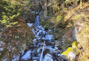
Planche des belle filles.Super.Difficulté moyenneb