Tocht Stappen Limoux - Magrie Gours - Photo

Magrie Gours

 Jean Marie Pons
Jean Marie Pons

Gebruiker

© OpenStreetMap contributors
Lengte
Lengte
21 km
Max. hoogte
Max. hoogte
394 m
Positief hoogteverschil
567 m
Km-Effort
Km-Effort  
28 km
Min. hoogte
Min. hoogte
172 m
Negatief hoogteverschil
568 m
Boucle
Boucle
Ja
Datum van aanmaak :
2022-01-13 07:52:32.561
Laatste wijziging :
2022-01-13 15:57:18.905

(1 Bericht)

Stappen
Stappen
5h15
Moeilijkheid : Gemakkelijk

Scan deze QR-code om de tocht te openen in de SityTrail-applicatie

Gratisgps-wandelapplicatie

Logo SityTrail SityTrail

IGN / Geografische instituten

SityTrail uit de App Store downloaden SityTrail uit Google Play downloaden

Logo SityTrail SityTrail World

De wereld gaat voor u open

SityTrail uit de App Store downloaden SityTrail uit Google Play downloaden SityTrail op Huawei AppGallery downloaden

Over ons

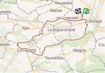
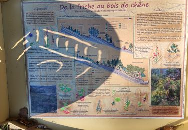
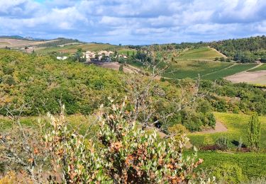
Tocht Stappen van 21 km beschikbaar op Occitanië, Aude, Limoux. Deze tocht wordt voorgesteld door Jean Marie Pons.

Hoogteprofiel

Plaatsbepaling

Land:
France
Regio :
Occitanië
Departement/Provincie :
Aude
Gemeente :
Limoux
Locatie:
Unknown
Vertrek:(UTM)
435183 ; 4767420 (31T) N.

Opmerkingen

Gelieve in te loggen om een commentaar of een beoordeling achter te laten


randonnée agréable, intéressante en ce jeudi 24-02-22. Le tracé au niveau du château, je ne l'ai pas vu, donc partir vers le lotissement à gauche, puis route. Audier.


Wandeltochten in de omgeving

Tocht Stappen Limoux - Limoux- Ninaute- Mounnet - Photo
Stappen
mikaou.t

Stappen

Medium
(1)
Limoux, Occitanië, Aude, France
10,9 km | 15,7 km-effort
3h 0min
Ja
Tocht Stappen Cournanel - Magrie-Cournanel Cabanes en fete - Photo
Stappen
jopost

Stappen

Heel gemakkelijk
(2)
Cournanel, Occitanië, Aude, France
7,4 km | 8,6 km-effort
4h 22min
Ja
Tocht Mountainbike Limoux - Limoux, toureille, croix st Pierre   - Photo
Mountainbike
schwarzy

Mountainbike

Moeilijk
Limoux, Occitanië, Aude, France
30 km | 42 km-effort
4h 41min
Ja
Tocht Mountainbike Pieusse - Los camins de la blanqueta 2006 - Photo
Mountainbike
tracegps

Mountainbike

Zeer moeilijk
Pieusse, Occitanië, Aude, France
53 km | 71 km-effort
4h 30min
Ja
Tocht Mountainbike Pieusse - Los camins de la blanqueta (prox. Limoux) - Photo
Mountainbike
tracegps

Mountainbike

Zeer moeilijk
Pieusse, Occitanië, Aude, France
53 km | 72 km-effort
6h 0min
Ja
Tocht Stappen Cournanel - COURNANEL les cabanes porposée par Pascale - Photo
Stappen
Mamilaure

Stappen

Heel gemakkelijk
Cournanel, Occitanië, Aude, France
6,1 km | 7,1 km-effort
1h 29min
Ja
Tocht Stappen Cournanel - cournanel les cabanes  - Photo
Stappen
cappelle

Stappen

Gemakkelijk
Cournanel, Occitanië, Aude, France
6,2 km | 7,2 km-effort
1h 56min
Ja
Tocht Stappen Pauligne - pauligne, Cassagnau, Le Soulié, Pauligne - Photo
Stappen
christinetondeur

Stappen

Gemakkelijk
Pauligne, Occitanië, Aude, France
9,5 km | 12,1 km-effort
2h 39min
Ja
Tocht Stappen Pauligne - Pauligne,Malras,La Digne d'Amont, Ajac, Cassagnau - Photo
Stappen
christinetondeur

Stappen

Medium
(1)
Pauligne, Occitanië, Aude, France
17,7 km | 24 km-effort
5h 28min
Ja


Sluiten
Mijn abonnementen