![](/images/other/stat-length.png)
![Tocht Paardrijden Unknown - 9 janvier 2022 - Photo](https://media.geolcdn.com/t/1900/400/ext.pjpeg?maxdim=2&url=https%3A%2F%2Fstatic1.geolcdn.com%2Fsiteimages%2Fupload%2Ffiles%2F1524743154cheval.jpg)
9 janvier 2022
roi
Gebruiker
![Lengte](/images/other/stat-length.png)
Lengte
10,1 km
![Max. hoogte](https://static1.geolcdn.com/siteimages/upload/files/1508320355ic_sort_altitude_max_24dp.png)
Max. hoogte
91 m
![Positief hoogteverschil](https://static1.geolcdn.com/siteimages/upload/files/1508320355ic_sort_den_pos_24dp.png)
Positief hoogteverschil
127 m
![Km-Effort](/images/other/stat-length.png)
Km-Effort
11,8 km
![Min. hoogte](https://static1.geolcdn.com/siteimages/upload/files/1508320355ic_sort_altitude_min_24dp.png)
Min. hoogte
46 m
![Negatief hoogteverschil](https://static1.geolcdn.com/siteimages/upload/files/1508320355ic_sort_den_neg_24dp.png)
Negatief hoogteverschil
128 m
![Boucle](https://static1.geolcdn.com/siteimages/upload/files/16400158638029165_repeat_loop_refresh_sync_direction_icon.png)
Boucle
Ja
Datum van aanmaak :
2022-01-09 09:46:13.0
Laatste wijziging :
2022-01-09 11:41:23.166
![Paardrijden](https://static1.geolcdn.com/sitytour/trail-icons/301.png)
1h54
Moeilijkheid : Gemakkelijk
![Scan deze QR-code om de tocht te openen in de SityTrail-applicatie](https://capi.geolives.com/qq0zvz2zws4bq2lad0pu/sitytour/trails/3045928/qr.png?size=200)
Gratisgps-wandelapplicatie
Over ons
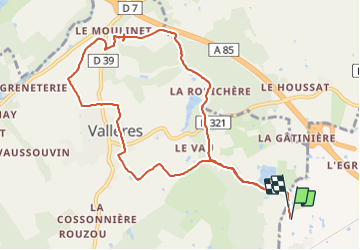
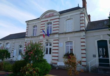
Tocht Paardrijden van 10,1 km beschikbaar op Centre-Val de Loire, Indre-et-Loire. Deze tocht wordt voorgesteld door roi.
Beschrijving
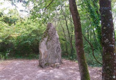
Un peu de tout. Attention erreur. Ne pas suivre l’autoroute mais prendre le chemin qui longe le ruisseau à gauche, puis après passer le petit bout de départemental. chemins sympas.
Plaatsbepaling
Land:
France
Regio :
Centre-Val de Loire
Departement/Provincie :
Indre-et-Loire
Gemeente :
Unknown
Locatie:
Unknown
Vertrek:(Dec)
Vertrek:(UTM)
311415 ; 5241715 (31T) N.
Opmerkingen
Wandeltochten in de omgeving
![Stappen Stappen](https://static1.geolcdn.com/sitytour/trail-icons/101.png)
Villandry - 2015 05 24
Stappen
Gemakkelijk
(1)
Villandry,
Centre-Val de Loire,
Indre-et-Loire,
France
![](/images/other/stat-length.png)
4,9 km | 5,7 km-effort
1h 15min
![](https://static1.geolcdn.com/siteimages/upload/files/16400158638029165_repeat_loop_refresh_sync_direction_icon.png)
Ja
![Tocht Stappen Vallères - Vallères le Hay - Zig zag Lignières-de-Touraine - 27.2km 300m 6h00 (50mn) - 2024 06 05 - Photo](https://media.geolcdn.com/t/375/260/b3324c15-4c92-4d98-acdf-5b4b32a3e010.jpg&format=jpg&maxdim=2)
![Stappen Stappen](https://static1.geolcdn.com/sitytour/trail-icons/101.png)
Vallères le Hay - Zig zag Lignières-de-Touraine - 27.2km 300m 6h00 (50mn) - 2...
Stappen
Medium
Vallères,
Centre-Val de Loire,
Indre-et-Loire,
France
![](/images/other/stat-length.png)
27 km | 31 km-effort
6h 0min
![](https://static1.geolcdn.com/siteimages/upload/files/16400158638029165_repeat_loop_refresh_sync_direction_icon.png)
Ja
![Tocht Stappen Vallères - Vallères - Zig zag Manoir de Fontenay - 26.2km 350m 6h00 (35mn) - 2024 05 31 - Photo](https://media.geolcdn.com/t/375/260/2dd7bae2-e64d-4c31-aa25-080d87181237.jpg&format=jpg&maxdim=2)
![Stappen Stappen](https://static1.geolcdn.com/sitytour/trail-icons/101.png)
Vallères - Zig zag Manoir de Fontenay - 26.2km 350m 6h00 (35mn) - 2024 05 31
Stappen
Gemakkelijk
Vallères,
Centre-Val de Loire,
Indre-et-Loire,
France
![](/images/other/stat-length.png)
26 km | 31 km-effort
6h 0min
![](https://static1.geolcdn.com/siteimages/upload/files/16400158638029165_repeat_loop_refresh_sync_direction_icon.png)
Ja
![Tocht Stappen Cinq-Mars-la-Pile - Cinq-Mars-la-Pile - Langeais - 14km 205m 3h05 - 2024 02 14 - Photo](https://media.geolcdn.com/t/375/260/bfe42b2e-405a-46df-8533-fbac70b0d338.jpg&format=jpg&maxdim=2)
![Stappen Stappen](https://static1.geolcdn.com/sitytour/trail-icons/101.png)
Cinq-Mars-la-Pile - Langeais - 14km 205m 3h05 - 2024 02 14
Stappen
Gemakkelijk
Cinq-Mars-la-Pile,
Centre-Val de Loire,
Indre-et-Loire,
France
![](/images/other/stat-length.png)
14 km | 16,7 km-effort
3h 5min
![](https://static1.geolcdn.com/siteimages/upload/files/16400158638029165_repeat_loop_refresh_sync_direction_icon.png)
Ja
![Tocht Stappen Azay-le-Rideau - Azay-le-Rideau - Goupillières Baulay - 15.1km 185m 3h35 - 2022 07 12 - Photo](https://media.geolcdn.com/t/375/260/8707bc61-0cf0-4af2-87b1-fc906fb58702.jpg&format=jpg&maxdim=2)
![Stappen Stappen](https://static1.geolcdn.com/sitytour/trail-icons/101.png)
Azay-le-Rideau - Goupillières Baulay - 15.1km 185m 3h35 - 2022 07 12
Stappen
Gemakkelijk
Azay-le-Rideau,
Centre-Val de Loire,
Indre-et-Loire,
France
![](/images/other/stat-length.png)
15,1 km | 17,6 km-effort
3h 35min
![](https://static1.geolcdn.com/siteimages/upload/files/16400158638029165_repeat_loop_refresh_sync_direction_icon.png)
Ja
![Tocht Stappen Savonnières - Savonnières - les Fontaines GR3 et PRs - 20.1km 190m 4h40 - 2022 05 12 - Photo](https://media.geolcdn.com/t/375/260/58a53b1f-8878-4695-8af8-d5fb36baa215.jpg&format=jpg&maxdim=2)
![Stappen Stappen](https://static1.geolcdn.com/sitytour/trail-icons/101.png)
Savonnières - les Fontaines GR3 et PRs - 20.1km 190m 4h40 - 2022 05 12
Stappen
Gemakkelijk
Savonnières,
Centre-Val de Loire,
Indre-et-Loire,
France
![](/images/other/stat-length.png)
20 km | 23 km-effort
4h 40min
![](https://static1.geolcdn.com/siteimages/upload/files/16400158638029165_repeat_loop_refresh_sync_direction_icon.png)
Ja
![Tocht Stappen Vallères - Vallères - Circuit 11km - 10.7km 115m 2h20 - 2020 07 11 - Photo](https://media.geolcdn.com/t/375/260/dacfb651-3bef-48cd-bbc1-bfa3f2be3086.jpg&format=jpg&maxdim=2)
![Stappen Stappen](https://static1.geolcdn.com/sitytour/trail-icons/101.png)
Vallères - Circuit 11km - 10.7km 115m 2h20 - 2020 07 11
Stappen
Heel gemakkelijk
Vallères,
Centre-Val de Loire,
Indre-et-Loire,
France
![](/images/other/stat-length.png)
10,7 km | 12,2 km-effort
2h 20min
![](https://static1.geolcdn.com/siteimages/upload/files/16400158638029165_repeat_loop_refresh_sync_direction_icon.png)
Ja
![Tocht Stappen - Druye - Sentier du menhir - 14km 95m 2h50 - 2019 08 03 - Photo](https://media.geolcdn.com/t/375/260/c6989684-aee6-4647-b6d8-0c0e44444f1d.jpg&format=jpg&maxdim=2)
![Stappen Stappen](https://static1.geolcdn.com/sitytour/trail-icons/101.png)
Druye - Sentier du menhir - 14km 95m 2h50 - 2019 08 03
Stappen
Heel gemakkelijk
,
Centre-Val de Loire,
Indre-et-Loire,
France
![](/images/other/stat-length.png)
14 km | 15,2 km-effort
2h 50min
![](https://static1.geolcdn.com/siteimages/upload/files/16400158638029165_repeat_loop_refresh_sync_direction_icon.png)
Ja
![Tocht Stappen Villandry - Villandry - Vallée du Vau - GR3 - 2016 02 27 - Photo](https://media.geolcdn.com/t/375/260/b4bedcce-c3ef-4637-9d7c-92bc166e5e4b.jpg&format=jpg&maxdim=2)
![Stappen Stappen](https://static1.geolcdn.com/sitytour/trail-icons/101.png)
Villandry - Vallée du Vau - GR3 - 2016 02 27
Stappen
Gemakkelijk
Villandry,
Centre-Val de Loire,
Indre-et-Loire,
France
![](/images/other/stat-length.png)
12,2 km | 14,4 km-effort
3h 0min
![](https://static1.geolcdn.com/siteimages/upload/files/16400158638029165_repeat_loop_refresh_sync_direction_icon.png)
Ja