![](/images/other/stat-length.png)
![Tocht Fiets Grimaud - sortie vélo route dans le var - Photo](https://media.geolcdn.com/t/1900/400/ext.pjpeg?maxdim=2&url=https%3A%2F%2Fstatic1.geolcdn.com%2Fsiteimages%2Fupload%2Ffiles%2F1524743154velo.jpg)
sortie vélo route dans le var
olivier26
Gebruiker
![Lengte](/images/other/stat-length.png)
Lengte
68 km
![Max. hoogte](https://static1.geolcdn.com/siteimages/upload/files/1508320355ic_sort_altitude_max_24dp.png)
Max. hoogte
354 m
![Positief hoogteverschil](https://static1.geolcdn.com/siteimages/upload/files/1508320355ic_sort_den_pos_24dp.png)
Positief hoogteverschil
898 m
![Km-Effort](/images/other/stat-length.png)
Km-Effort
80 km
![Min. hoogte](https://static1.geolcdn.com/siteimages/upload/files/1508320355ic_sort_altitude_min_24dp.png)
Min. hoogte
0 m
![Negatief hoogteverschil](https://static1.geolcdn.com/siteimages/upload/files/1508320355ic_sort_den_neg_24dp.png)
Negatief hoogteverschil
898 m
![Boucle](https://static1.geolcdn.com/siteimages/upload/files/16400158638029165_repeat_loop_refresh_sync_direction_icon.png)
Boucle
Ja
Datum van aanmaak :
2014-12-10 00:00:00.0
Laatste wijziging :
2014-12-10 00:00:00.0
![Fiets](https://static1.geolcdn.com/sitytour/trail-icons/200.png)
3h17
Moeilijkheid : Medium
![Scan deze QR-code om de tocht te openen in de SityTrail-applicatie](https://capi.geolives.com/qq0zvz2zws4bq2lad0pu/sitytour/trails/304550/qr.png?size=200)
Gratisgps-wandelapplicatie
Over ons
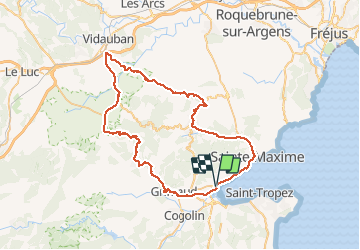
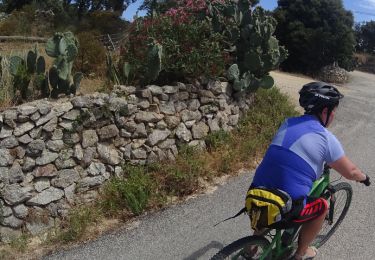
Tocht Fiets van 68 km beschikbaar op Provence-Alpes-Côte d'Azur, Var, Grimaud. Deze tocht wordt voorgesteld door olivier26.
Beschrijving
boucle dans le massif des maures, par grimaud, garde frenet, vidauban, plan de la tour, st maxime, port grimaud
Plaatsbepaling
Land:
France
Regio :
Provence-Alpes-Côte d'Azur
Departement/Provincie :
Var
Gemeente :
Grimaud
Locatie:
Unknown
Vertrek:(Dec)
Vertrek:(UTM)
303664 ; 4794607 (32T) N.
Opmerkingen
Wandeltochten in de omgeving
![Tocht Mountainbike Cogolin - peinier - Photo](https://media.geolcdn.com/t/375/260/ext.jpg?maxdim=2&url=https%3A%2F%2Fservices.sitytrail.com%2FGeolivesWS%2FDownloadMedia.ashx%3FTrailID%3D137318%26Media%3D20120704191905.jpeg)
![Mountainbike Mountainbike](https://static1.geolcdn.com/sitytour/trail-icons/202.png)
peinier
Mountainbike
Medium
(1)
Cogolin,
Provence-Alpes-Côte d'Azur,
Var,
France
![](/images/other/stat-length.png)
30 km | 40 km-effort
1h 57min
![](https://static1.geolcdn.com/siteimages/upload/files/16400158638029165_repeat_loop_refresh_sync_direction_icon.png)
Ja
![Tocht Stappen Saint-Tropez - Golfe de St Tropez - Photo](https://media.geolcdn.com/t/375/260/ext.jpg?maxdim=2&url=https%3A%2F%2Fservices.sitytrail.com%2FGeolivesWS%2FDownloadMedia.ashx%3FTrailID%3D107154%26Media%3D11997_5.jpg)
![Stappen Stappen](https://static1.geolcdn.com/sitytour/trail-icons/101.png)
Golfe de St Tropez
Stappen
Moeilijk
(2)
Saint-Tropez,
Provence-Alpes-Côte d'Azur,
Var,
France
![](/images/other/stat-length.png)
15,1 km | 17,6 km-effort
4h 30min
![](https://static1.geolcdn.com/siteimages/upload/files/16400158638029165_repeat_loop_refresh_sync_direction_icon.png)
Ja
![Tocht Stappen Cogolin - val d\'Astier,St Ferreol, Pradels,val d\'Astier - Photo](https://media.geolcdn.com/t/375/260/ext.jpg?maxdim=2&url=https%3A%2F%2Fstatic1.geolcdn.com%2Fsiteimages%2Fupload%2Ffiles%2F1553511878bg_sport_marche.png)
![Stappen Stappen](https://static1.geolcdn.com/sitytour/trail-icons/101.png)
val d\'Astier,St Ferreol, Pradels,val d\'Astier
Stappen
Moeilijk
(1)
Cogolin,
Provence-Alpes-Côte d'Azur,
Var,
France
![](/images/other/stat-length.png)
12 km | 17,3 km-effort
5h 0min
![](https://static1.geolcdn.com/siteimages/upload/files/16400158638029165_repeat_loop_refresh_sync_direction_icon.png)
Ja
![Tocht Mountainbike Grimaud - VTT de Port -Grimaud - Photo](https://media.geolcdn.com/t/375/260/ext.jpg?maxdim=2&url=https%3A%2F%2Fservices.sitytrail.com%2FGeolivesWS%2FDownloadMedia.ashx%3FTrailID%3D795928%26Media%3Dd1a4096c-7e26-4780-acbc-fe0cf30ee0df.JPG)
![Mountainbike Mountainbike](https://static1.geolcdn.com/sitytour/trail-icons/202.png)
VTT de Port -Grimaud
Mountainbike
Medium
Grimaud,
Provence-Alpes-Côte d'Azur,
Var,
France
![](/images/other/stat-length.png)
21 km | 26 km-effort
1h 45min
![](https://static1.geolcdn.com/siteimages/upload/files/16400158638029165_repeat_loop_refresh_sync_direction_icon.png)
Ja
![Tocht Mountainbike Grimaud - VTT du Plan de la Tour - Photo](https://media.geolcdn.com/t/375/260/ext.jpg?maxdim=2&url=https%3A%2F%2Fservices.sitytrail.com%2FGeolivesWS%2FDownloadMedia.ashx%3FTrailID%3D787323%26Media%3D86ee6b79-1220-4d35-8e8c-b77bb4ae8c68.JPG)
![Mountainbike Mountainbike](https://static1.geolcdn.com/sitytour/trail-icons/202.png)
VTT du Plan de la Tour
Mountainbike
Moeilijk
(1)
Grimaud,
Provence-Alpes-Côte d'Azur,
Var,
France
![](/images/other/stat-length.png)
35 km | 46 km-effort
2h 59min
![](https://static1.geolcdn.com/siteimages/upload/files/16400158638029165_repeat_loop_refresh_sync_direction_icon.png)
Ja
![Tocht Mountainbike Gassin - La Nartelle- depart Bourrian - Photo](https://media.geolcdn.com/t/375/260/ext.jpg?maxdim=2&url=https%3A%2F%2Fstatic1.geolcdn.com%2Fsiteimages%2Fupload%2Ffiles%2F1524743154velo.jpg)
![Mountainbike Mountainbike](https://static1.geolcdn.com/sitytour/trail-icons/202.png)
La Nartelle- depart Bourrian
Mountainbike
Medium
(1)
Gassin,
Provence-Alpes-Côte d'Azur,
Var,
France
![](/images/other/stat-length.png)
24 km | 31 km-effort
3h 11min
![](https://static1.geolcdn.com/siteimages/upload/files/16400158638029165_repeat_loop_refresh_sync_direction_icon.png)
Ja
![Tocht Mountainbike Gassin - Patapan - Photo](https://media.geolcdn.com/t/375/260/ext.jpg?maxdim=2&url=https%3A%2F%2Fstatic1.geolcdn.com%2Fsiteimages%2Fupload%2Ffiles%2F1524743154velo.jpg)
![Mountainbike Mountainbike](https://static1.geolcdn.com/sitytour/trail-icons/202.png)
Patapan
Mountainbike
Medium
(1)
Gassin,
Provence-Alpes-Côte d'Azur,
Var,
France
![](/images/other/stat-length.png)
37 km | 47 km-effort
2h 24min
![](https://static1.geolcdn.com/siteimages/upload/files/16400158638029165_repeat_loop_refresh_sync_direction_icon.png)
Neen
![Tocht Stappen Saint-Tropez - St Tropez littoral - Photo](https://media.geolcdn.com/t/375/260/072b31b2-52f6-4dca-a49f-5baffe5c7dc9.jpg&format=jpg&maxdim=2)
![Stappen Stappen](https://static1.geolcdn.com/sitytour/trail-icons/101.png)
St Tropez littoral
Stappen
Medium
Saint-Tropez,
Provence-Alpes-Côte d'Azur,
Var,
France
![](/images/other/stat-length.png)
18,3 km | 22 km-effort
6h 3min
![](https://static1.geolcdn.com/siteimages/upload/files/16400158638029165_repeat_loop_refresh_sync_direction_icon.png)
Ja
![Tocht Stappen Grimaud - Grimaud - le pont des fées - Mont Roux 11.3.23 - Photo](https://media.geolcdn.com/t/375/260/b931d4cf-3c48-45c3-9286-94f622997895.jpg&format=jpg&maxdim=2)
![Stappen Stappen](https://static1.geolcdn.com/sitytour/trail-icons/101.png)
Grimaud - le pont des fées - Mont Roux 11.3.23
Stappen
Medium
Grimaud,
Provence-Alpes-Côte d'Azur,
Var,
France
![](/images/other/stat-length.png)
8,6 km | 13,7 km-effort
3h 15min
![](https://static1.geolcdn.com/siteimages/upload/files/16400158638029165_repeat_loop_refresh_sync_direction_icon.png)
Ja