![](/images/other/stat-length.png)
![Tocht Ski randonnée Orcières - objectif Rocher blanc mais trop long donc direction chapeau rouge - Photo](https://media.geolcdn.com/t/1900/400/7cce85a4-567c-43a2-8949-4f1bb1d57721.jpg&format=pjpeg&maxdim=2)
objectif Rocher blanc mais trop long donc direction chapeau rouge
nadd73
Gebruiker GUIDE
![Lengte](/images/other/stat-length.png)
![Max. hoogte](https://static1.geolcdn.com/siteimages/upload/files/1508320355ic_sort_altitude_max_24dp.png)
![Positief hoogteverschil](https://static1.geolcdn.com/siteimages/upload/files/1508320355ic_sort_den_pos_24dp.png)
![Km-Effort](/images/other/stat-length.png)
![Min. hoogte](https://static1.geolcdn.com/siteimages/upload/files/1508320355ic_sort_altitude_min_24dp.png)
![Negatief hoogteverschil](https://static1.geolcdn.com/siteimages/upload/files/1508320355ic_sort_den_neg_24dp.png)
![Boucle](https://static1.geolcdn.com/siteimages/upload/files/16400158638029165_repeat_loop_refresh_sync_direction_icon.png)
![Ski randonnée](https://static1.geolcdn.com/sitytour/trail-icons/503.png)
6h00
Moeilijkheid : Medium
![Scan deze QR-code om de tocht te openen in de SityTrail-applicatie](https://capi.geolives.com/qq0zvz2zws4bq2lad0pu/sitytour/trails/3044499/qr.png?size=200)
Gratisgps-wandelapplicatie
Over ons
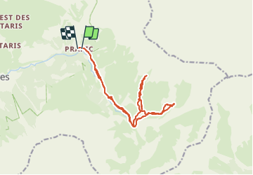
Tocht Ski randonnée van 17,2 km beschikbaar op Provence-Alpes-Côte d'Azur, Hautes-Alpes, Orcières. Deze tocht wordt voorgesteld door nadd73.
Beschrijving
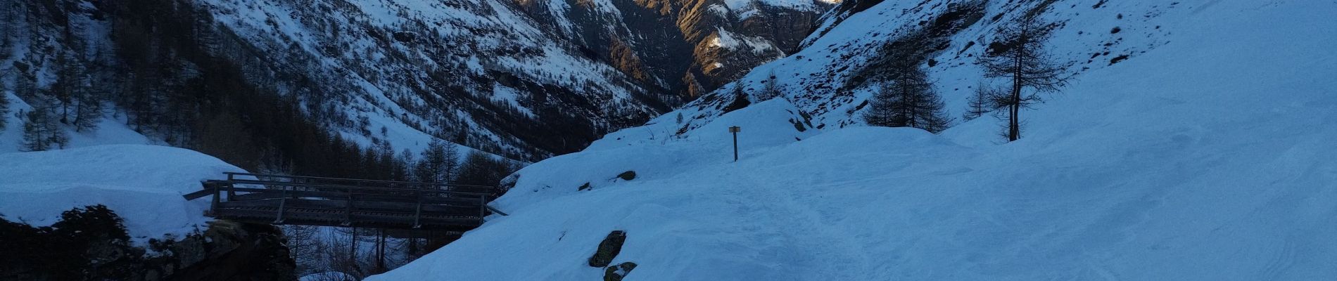
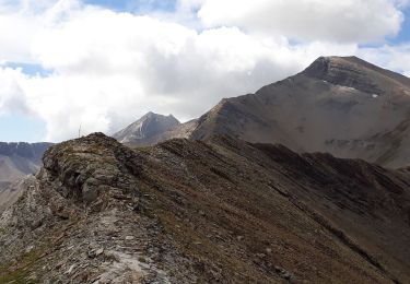
Prapic, je suis partie pour le Rocher blanc mais une fois au dessus de la cabane de Vallon clos un cheminement dans un Vallon bien serré me fit renoncer.
Du coup, je suis descendue jusqu'à pouvoir remonter à Chapeau rouge mais je me suis arrêtée avant car il était déjà 15h30 et l'ombre est vite là à cette période.
Plaatsbepaling
Opmerkingen
Wandeltochten in de omgeving
![Tocht Stappen Orcières - Le Forest des marches - Photo](https://media.geolcdn.com/t/375/260/1bbb2305-7ec0-44b0-abf9-1e50226e1407.jpg&format=jpg&maxdim=2)
![Stappen Stappen](https://static1.geolcdn.com/sitytour/trail-icons/101.png)
Stappen
![](/images/other/stat-length.png)
![](https://static1.geolcdn.com/siteimages/upload/files/16400158638029165_repeat_loop_refresh_sync_direction_icon.png)
![Tocht Stappen Orcières - R45 Marmottes a Prapic - Photo](https://media.geolcdn.com/t/375/260/9e9dbd3a-1b41-4834-8fb6-1b5270d2390e.jpg&format=jpg&maxdim=2)
![Stappen Stappen](https://static1.geolcdn.com/sitytour/trail-icons/101.png)
Stappen
![](/images/other/stat-length.png)
![](https://static1.geolcdn.com/siteimages/upload/files/16400158638029165_repeat_loop_refresh_sync_direction_icon.png)
![Tocht Stappen Orcières - Orcieres (Hautes Alpes) - Photo](https://media.geolcdn.com/t/375/260/8cda8352-22b8-4c39-b048-400b3169e428.jpg&format=jpg&maxdim=2)
![Stappen Stappen](https://static1.geolcdn.com/sitytour/trail-icons/101.png)
Stappen
![](/images/other/stat-length.png)
![](https://static1.geolcdn.com/siteimages/upload/files/16400158638029165_repeat_loop_refresh_sync_direction_icon.png)
![Tocht Stappen Orcières - Roc Diolon par le col de Fressinieres 11/08/23 - Photo](https://media.geolcdn.com/t/375/260/5a167a74-49bc-4637-b777-9bd30e412110.jpg&format=jpg&maxdim=2)
![Stappen Stappen](https://static1.geolcdn.com/sitytour/trail-icons/101.png)
Stappen
![](/images/other/stat-length.png)
![](https://static1.geolcdn.com/siteimages/upload/files/16400158638029165_repeat_loop_refresh_sync_direction_icon.png)
![Tocht Ski randonnée Orcières - L'homme de Prapic - Photo](https://media.geolcdn.com/t/375/260/728ac5de-7771-4482-8258-55cd8c2ebd98.jpg&format=jpg&maxdim=2)
![Ski randonnée Ski randonnée](https://static1.geolcdn.com/sitytour/trail-icons/503.png)
Ski randonnée
![](/images/other/stat-length.png)
![](https://static1.geolcdn.com/siteimages/upload/files/16400158638029165_repeat_loop_refresh_sync_direction_icon.png)
![Stappen Stappen](https://static1.geolcdn.com/sitytour/trail-icons/101.png)
Stappen
![](/images/other/stat-length.png)
![](https://static1.geolcdn.com/siteimages/upload/files/16400158638029165_repeat_loop_refresh_sync_direction_icon.png)
![Tocht Stappen Orcières - Lac des Pisses - Photo](https://media.geolcdn.com/t/375/260/72d69359-d69b-4e79-86c6-e3022c079ec2.jpg&format=jpg&maxdim=2)
![Stappen Stappen](https://static1.geolcdn.com/sitytour/trail-icons/101.png)
Stappen
![](/images/other/stat-length.png)
![](https://static1.geolcdn.com/siteimages/upload/files/16400158638029165_repeat_loop_refresh_sync_direction_icon.png)
![Tocht Ski randonnée Orcières - Le chapeau rouge - Photo](https://media.geolcdn.com/t/375/260/4359da6c-2220-46c4-9d30-4f44fc07feb5.jpg&format=jpg&maxdim=2)
![Ski randonnée Ski randonnée](https://static1.geolcdn.com/sitytour/trail-icons/503.png)
Ski randonnée
![](/images/other/stat-length.png)
![](https://static1.geolcdn.com/siteimages/upload/files/16400158638029165_repeat_loop_refresh_sync_direction_icon.png)
![Tocht Stappen Orcières - Col des Tourettes - Croix Lorraine 08/09/18 - Photo](https://media.geolcdn.com/t/375/260/af57e72a-0044-4f3d-888f-9184aa14c00c.jpg&format=jpg&maxdim=2)
![Stappen Stappen](https://static1.geolcdn.com/sitytour/trail-icons/101.png)
Stappen
![](/images/other/stat-length.png)
![](https://static1.geolcdn.com/siteimages/upload/files/16400158638029165_repeat_loop_refresh_sync_direction_icon.png)