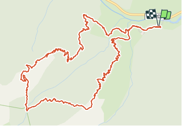
![](/images/other/stat-length.png)
![Tocht Stappen Isola - St Eurosie Isola - Photo](https://media.geolcdn.com/t/1900/400/ab0ea8f4-80b3-4e41-97d5-31aed48e4d39.jpg&format=pjpeg&maxdim=2)
St Eurosie Isola
GrouGary
Gebruiker
![Lengte](/images/other/stat-length.png)
![Max. hoogte](https://static1.geolcdn.com/siteimages/upload/files/1508320355ic_sort_altitude_max_24dp.png)
![Positief hoogteverschil](https://static1.geolcdn.com/siteimages/upload/files/1508320355ic_sort_den_pos_24dp.png)
![Km-Effort](/images/other/stat-length.png)
![Min. hoogte](https://static1.geolcdn.com/siteimages/upload/files/1508320355ic_sort_altitude_min_24dp.png)
![Negatief hoogteverschil](https://static1.geolcdn.com/siteimages/upload/files/1508320355ic_sort_den_neg_24dp.png)
![Boucle](https://static1.geolcdn.com/siteimages/upload/files/16400158638029165_repeat_loop_refresh_sync_direction_icon.png)
![Stappen](https://static1.geolcdn.com/sitytour/trail-icons/101.png)
3h53
Moeilijkheid : Medium
![Scan deze QR-code om de tocht te openen in de SityTrail-applicatie](https://capi.geolives.com/qq0zvz2zws4bq2lad0pu/sitytour/trails/3030330/qr.png?size=200)
Gratisgps-wandelapplicatie
Over ons
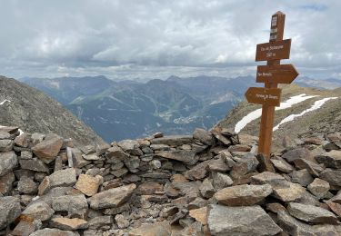
Tocht Stappen van 10,4 km beschikbaar op Provence-Alpes-Côte d'Azur, Alpes-Maritimes, Isola. Deze tocht wordt voorgesteld door GrouGary.
Beschrijving
Circuit pas très bien balisé dans la 1ère moitié, quelques erreurs dans le circuit (passer sous la maison nouvellement construite,... ne pas suivre les nombreuses drailles/confusion avec PR)
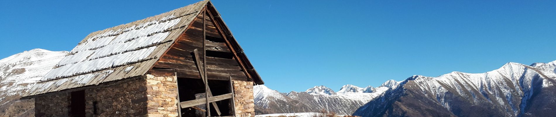
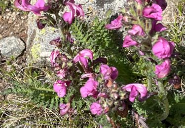
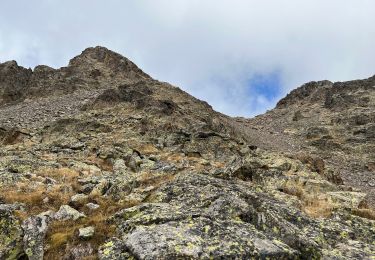
Montée et descente soutenues mais sans difficultés techniques. Le coin chapelle Ste Eurosie et hameau super sous le soleil et la neige.
Nous avons conservé en permanence les "cramponnettes" sur les sentiers verglacés.
Plaatsbepaling
Opmerkingen
Wandeltochten in de omgeving
![Tocht Stappen Isola - Châtaigneraie ISOLA - Photo](https://media.geolcdn.com/t/375/260/ext.jpg?maxdim=2&url=https%3A%2F%2Fservices.sitytrail.com%2FGeolivesWS%2FDownloadMedia.ashx%3FTrailID%3D470503%26Media%3D20150910120215.jpg)
![Stappen Stappen](https://static1.geolcdn.com/sitytour/trail-icons/101.png)
Stappen
![](/images/other/stat-length.png)
![](https://static1.geolcdn.com/siteimages/upload/files/16400158638029165_repeat_loop_refresh_sync_direction_icon.png)
![Tocht Stappen Isola - Fontaine St Laurent par Collet de Léchio et Cascade de Louch Isola Village - Photo](https://media.geolcdn.com/t/375/260/db3d6713-0c9e-4c65-af5d-a138b43add5e.jpg&format=jpg&maxdim=2)
![Stappen Stappen](https://static1.geolcdn.com/sitytour/trail-icons/101.png)
Stappen
![](/images/other/stat-length.png)
![](https://static1.geolcdn.com/siteimages/upload/files/16400158638029165_repeat_loop_refresh_sync_direction_icon.png)
![Tocht Stappen Saint-Étienne-de-Tinée - Le Corborant - Photo](https://media.geolcdn.com/t/375/260/4e6a72e4-8dfa-499a-bed5-882b283528e3.jpeg&format=jpg&maxdim=2)
![Stappen Stappen](https://static1.geolcdn.com/sitytour/trail-icons/101.png)
Stappen
![](/images/other/stat-length.png)
![](https://static1.geolcdn.com/siteimages/upload/files/16400158638029165_repeat_loop_refresh_sync_direction_icon.png)
![Tocht sport Saint-Étienne-de-Tinée - Tête de l autaret Lagos colla longa - Photo](https://media.geolcdn.com/t/375/260/0f54380f-0cc0-41e9-83d3-976012bf1985.jpg&format=jpg&maxdim=2)
sport
![](/images/other/stat-length.png)
![](https://static1.geolcdn.com/siteimages/upload/files/16400158638029165_repeat_loop_refresh_sync_direction_icon.png)
![Tocht Stappen Saint-Étienne-de-Tinée - Pas du Corborant - Photo](https://media.geolcdn.com/t/375/260/1437e916-f1b9-46ba-a4bd-95ebbd78d5eb.jpg&format=jpg&maxdim=2)
![Stappen Stappen](https://static1.geolcdn.com/sitytour/trail-icons/101.png)
Stappen
![](/images/other/stat-length.png)
![](https://static1.geolcdn.com/siteimages/upload/files/16400158638029165_repeat_loop_refresh_sync_direction_icon.png)
![Tocht Stappen Saint-Étienne-de-Tinée - Pas de Barbacane 2 - Photo](https://media.geolcdn.com/t/375/260/cd41cdc8-c1e7-4db0-ab77-f088a6eb56ed.jpg&format=jpg&maxdim=2)
![Stappen Stappen](https://static1.geolcdn.com/sitytour/trail-icons/101.png)
Stappen
![](/images/other/stat-length.png)
![](https://static1.geolcdn.com/siteimages/upload/files/16400158638029165_repeat_loop_refresh_sync_direction_icon.png)
![Tocht Stappen Saint-Étienne-de-Tinée - Pas de Barbacane hiver - Photo](https://media.geolcdn.com/t/375/260/f9b76504-3e86-4a58-9943-dbd98f791700.jpg&format=jpg&maxdim=2)
![Stappen Stappen](https://static1.geolcdn.com/sitytour/trail-icons/101.png)
Stappen
![](/images/other/stat-length.png)
![](https://static1.geolcdn.com/siteimages/upload/files/16400158638029165_repeat_loop_refresh_sync_direction_icon.png)
![Tocht Te voet Isola - Boucle de Louch - Photo](https://media.geolcdn.com/t/375/260/3b66ff9e-06f4-4751-843b-3367523d8fc7.jpeg&format=jpg&maxdim=2)
![Te voet Te voet](https://static1.geolcdn.com/sitytour/trail-icons/100.png)
Te voet
![](/images/other/stat-length.png)
![](https://static1.geolcdn.com/siteimages/upload/files/16400158638029165_repeat_loop_refresh_sync_direction_icon.png)
![Tocht Stappen Isola - Col de la Guercha - Photo](https://media.geolcdn.com/t/375/260/8bbb67ab-24b8-4128-a1e0-12ad3d57f0e4.jpg&format=jpg&maxdim=2)
![Stappen Stappen](https://static1.geolcdn.com/sitytour/trail-icons/101.png)
Stappen
![](/images/other/stat-length.png)
![](https://static1.geolcdn.com/siteimages/upload/files/16400158638029165_repeat_loop_refresh_sync_direction_icon.png)