![](/images/other/stat-length.png)
![Tocht Stappen Pervenchères - [Itinéraire] Le chêne de La Lambonnière - Photo](https://media.geolcdn.com/t/1900/400/be123da2-77bf-4b7d-8049-3c5fe0c5807a.jpg&format=pjpeg&maxdim=2)
[Itinéraire] Le chêne de La Lambonnière
ODDAD78
Gebruiker
![Lengte](/images/other/stat-length.png)
![Max. hoogte](https://static1.geolcdn.com/siteimages/upload/files/1508320355ic_sort_altitude_max_24dp.png)
![Positief hoogteverschil](https://static1.geolcdn.com/siteimages/upload/files/1508320355ic_sort_den_pos_24dp.png)
![Km-Effort](/images/other/stat-length.png)
![Min. hoogte](https://static1.geolcdn.com/siteimages/upload/files/1508320355ic_sort_altitude_min_24dp.png)
![Negatief hoogteverschil](https://static1.geolcdn.com/siteimages/upload/files/1508320355ic_sort_den_neg_24dp.png)
![Boucle](https://static1.geolcdn.com/siteimages/upload/files/16400158638029165_repeat_loop_refresh_sync_direction_icon.png)
![Stappen](https://static1.geolcdn.com/sitytour/trail-icons/101.png)
2h14
Moeilijkheid : Medium
![Scan deze QR-code om de tocht te openen in de SityTrail-applicatie](https://capi.geolives.com/qq0zvz2zws4bq2lad0pu/sitytour/trails/3022908/qr.png?size=200)
Gratisgps-wandelapplicatie
Over ons
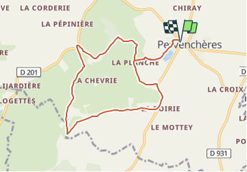
Tocht Stappen van 8,7 km beschikbaar op Normandië, Orne, Pervenchères. Deze tocht wordt voorgesteld door ODDAD78.
Beschrijving
Découverte d’un chêne remarquable, plusieurs fois centenaires et de son site. Jolis points de vue et coins de pique-nique.
Partant de la place des Pervenches, le chemin longe l’étang de Pervenchères, se prolonge par un chemin ombragé jusqu’à La Lambonnière: son chêne pluricentenaire et le site consacré à la découverte de la nature. Le chemin se poursuit ensiuite vers l’entrée du Grand Refuge SPA puis par un sentier qui rejoint la route de la Haute Crête. On y découvre un beau panorama sur Pervenchères, avant d’amorcer le retour vers le bourg.
Départ / Arrivée : Pervenchères, près de l'église
Communes traversées : Pervenchères, Montgaudry
Peu après le monument aux morts, à l’extrémité de la place, prendre à gauche la rue du Vieux Chêne, menant à l’étang communal. A hauteur de Moire, continuer tout droit par un chemin en herbe, en lisière de bois.
A l’intersection bifurquer à droite, suivre un chemin en herbe. Longer une peupleraie, à son extrémité, à droite le chemin conduit au site de la Lambonnière
Prendre à gauche vers la Chevrie et le site du Grand Refuge de la SPA. Franchir le ruisseau de Belnoë. Emprunter sur la droite un chemin plus étroit. Humide par endroit ce chemin remonte à son extrémité et débouche sur une petite route goudronnée, près de la Haute Crête.
Tourner à gauche sur la route goudronnée, Les Hauts Bois, Monthodevin, le petit Monthodevin.
Au carrefour tourner à gauche sur le D 297. Les Bondes. Quitter la départementale sur la gauche pour prendre le chemin de La Planche. Continuer jusqu’au hangar au bout du chemin et prendre à droite. Revenir par l’itinéraire de départ.
Plaatsbepaling
Opmerkingen
Wandeltochten in de omgeving
![Tocht Stappen Pervenchères - [Itinéraire] Le bois du Châtaignier - Photo](https://media.geolcdn.com/t/375/260/32811f16-13a1-4095-9db6-b0b4ae9783db.png&format=jpg&maxdim=2)
![Stappen Stappen](https://static1.geolcdn.com/sitytour/trail-icons/101.png)
Stappen
![](/images/other/stat-length.png)
![](https://static1.geolcdn.com/siteimages/upload/files/16400158638029165_repeat_loop_refresh_sync_direction_icon.png)
![Tocht Stappen Pervenchères - SityTrail - Le chêne de La Lambonnière 8,7 km - Photo](https://media.geolcdn.com/t/375/260/ext.jpg?maxdim=2&url=https%3A%2F%2Fstatic1.geolcdn.com%2Fsiteimages%2Fupload%2Ffiles%2F1553511878bg_sport_marche.png)
![Stappen Stappen](https://static1.geolcdn.com/sitytour/trail-icons/101.png)
Stappen
![](/images/other/stat-length.png)
![](https://static1.geolcdn.com/siteimages/upload/files/16400158638029165_repeat_loop_refresh_sync_direction_icon.png)
![Tocht Stappen Pervenchères - SityTrail - Le Bois du Châtaignier 4,5 km - Photo](https://media.geolcdn.com/t/375/260/ext.jpg?maxdim=2&url=https%3A%2F%2Fstatic1.geolcdn.com%2Fsiteimages%2Fupload%2Ffiles%2F1553511878bg_sport_marche.png)
![Stappen Stappen](https://static1.geolcdn.com/sitytour/trail-icons/101.png)
Stappen
![](/images/other/stat-length.png)
![](https://static1.geolcdn.com/siteimages/upload/files/16400158638029165_repeat_loop_refresh_sync_direction_icon.png)
![Tocht Stappen Pervenchères - Pervenchères Bois du Chätaignier 4Km - Photo](https://media.geolcdn.com/t/375/260/ext.jpg?maxdim=2&url=https%3A%2F%2Fstatic1.geolcdn.com%2Fsiteimages%2Fupload%2Ffiles%2F1553511878bg_sport_marche.png)
![Stappen Stappen](https://static1.geolcdn.com/sitytour/trail-icons/101.png)
Stappen
![](/images/other/stat-length.png)
![](https://static1.geolcdn.com/siteimages/upload/files/16400158638029165_repeat_loop_refresh_sync_direction_icon.png)
![Tocht Stappen Pervenchères - Boucle de Pervenchères 20Km - Photo](https://media.geolcdn.com/t/375/260/ext.jpg?maxdim=2&url=https%3A%2F%2Fstatic1.geolcdn.com%2Fsiteimages%2Fupload%2Ffiles%2F1553511878bg_sport_marche.png)
![Stappen Stappen](https://static1.geolcdn.com/sitytour/trail-icons/101.png)
Stappen
![](/images/other/stat-length.png)
![](https://static1.geolcdn.com/siteimages/upload/files/16400158638029165_repeat_loop_refresh_sync_direction_icon.png)
![Tocht Stappen Montgaudry - Montgaudry / Contilly 9,3 Km - Photo](https://media.geolcdn.com/t/375/260/ext.jpg?maxdim=2&url=https%3A%2F%2Fstatic1.geolcdn.com%2Fsiteimages%2Fupload%2Ffiles%2F1553511878bg_sport_marche.png)
![Stappen Stappen](https://static1.geolcdn.com/sitytour/trail-icons/101.png)
Stappen
![](/images/other/stat-length.png)
![](https://static1.geolcdn.com/siteimages/upload/files/16400158638029165_repeat_loop_refresh_sync_direction_icon.png)
![Tocht Stappen Contilly - Contilly 8,0 Km - Photo](https://media.geolcdn.com/t/375/260/ext.jpg?maxdim=2&url=https%3A%2F%2Fstatic1.geolcdn.com%2Fsiteimages%2Fupload%2Ffiles%2F1553511878bg_sport_marche.png)
![Stappen Stappen](https://static1.geolcdn.com/sitytour/trail-icons/101.png)
Stappen
![](/images/other/stat-length.png)
![](https://static1.geolcdn.com/siteimages/upload/files/16400158638029165_repeat_loop_refresh_sync_direction_icon.png)
![Tocht Stappen Pervenchères - Pervenchère - La Lambonière 8.4 Km - Photo](https://media.geolcdn.com/t/375/260/cf86cba0-7c88-47ca-97bd-a73cecead7c6.jpg&format=jpg&maxdim=2)
![Stappen Stappen](https://static1.geolcdn.com/sitytour/trail-icons/101.png)
Stappen
![](/images/other/stat-length.png)
![](https://static1.geolcdn.com/siteimages/upload/files/16400158638029165_repeat_loop_refresh_sync_direction_icon.png)
![Tocht Te voet Pervenchères - [Itinéraire] Le bois du Châtaignier - Photo](https://media.geolcdn.com/t/375/260/ext.jpg?maxdim=2&url=https%3A%2F%2Fstatic1.geolcdn.com%2Fsiteimages%2Fupload%2Ffiles%2F1545311037marcheuse_200dpi.jpg)
![Te voet Te voet](https://static1.geolcdn.com/sitytour/trail-icons/100.png)
Te voet
![](/images/other/stat-length.png)
![](https://static1.geolcdn.com/siteimages/upload/files/16400158638029165_repeat_loop_refresh_sync_direction_icon.png)
Belle balade dans les collines du Perche. Jolis chemins ombragés, bordés de prairies et de collines boisées. Les chevaux dans les prés font partie de la réjouissance de la promenade.