![](/images/other/stat-length.png)
![Tocht Sneeuwschoenen Beaumont-du-Ventoux - Mont Serein , mont Ventoux l hiver - Photo](https://media.geolcdn.com/t/1900/400/ext.pjpeg?maxdim=2&url=https%3A%2F%2Fstatic1.geolcdn.com%2Fsiteimages%2Fupload%2Ffiles%2F1524743153raquette.jpg)
Mont Serein , mont Ventoux l hiver
Jacques ALBERT
Gebruiker
![Lengte](/images/other/stat-length.png)
Lengte
11,2 km
![Max. hoogte](https://static1.geolcdn.com/siteimages/upload/files/1508320355ic_sort_altitude_max_24dp.png)
Max. hoogte
1910 m
![Positief hoogteverschil](https://static1.geolcdn.com/siteimages/upload/files/1508320355ic_sort_den_pos_24dp.png)
Positief hoogteverschil
481 m
![Km-Effort](/images/other/stat-length.png)
Km-Effort
17,6 km
![Min. hoogte](https://static1.geolcdn.com/siteimages/upload/files/1508320355ic_sort_altitude_min_24dp.png)
Min. hoogte
1434 m
![Negatief hoogteverschil](https://static1.geolcdn.com/siteimages/upload/files/1508320355ic_sort_den_neg_24dp.png)
Negatief hoogteverschil
481 m
![Boucle](https://static1.geolcdn.com/siteimages/upload/files/16400158638029165_repeat_loop_refresh_sync_direction_icon.png)
Boucle
Ja
Datum van aanmaak :
2021-12-08 14:40:45.275
Laatste wijziging :
2021-12-08 14:46:38.11
![Sneeuwschoenen](https://static1.geolcdn.com/sitytour/trail-icons/504.png)
5h00
Moeilijkheid : Moeilijk
![Scan deze QR-code om de tocht te openen in de SityTrail-applicatie](https://capi.geolives.com/qq0zvz2zws4bq2lad0pu/sitytour/trails/3021619/qr.png?size=200)
Gratisgps-wandelapplicatie
Over ons
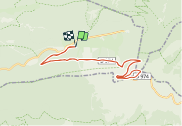
Tocht Sneeuwschoenen van 11,2 km beschikbaar op Provence-Alpes-Côte d'Azur, Vaucluse, Beaumont-du-Ventoux. Deze tocht wordt voorgesteld door Jacques ALBERT.
Beschrijving
Randonnées hivernale , en raquettes ou suivant l etat de la neige et méteo , peut etre ouvete par 2 marcheurs raquettes et suite en chaussures de randonnées pour neige
Plaatsbepaling
Land:
France
Regio :
Provence-Alpes-Côte d'Azur
Departement/Provincie :
Vaucluse
Gemeente :
Beaumont-du-Ventoux
Locatie:
Unknown
Vertrek:(Dec)
Vertrek:(UTM)
680520 ; 4894447 (31T) N.
Opmerkingen
Wandeltochten in de omgeving
![Tocht Stappen Bédoin - DEMOISELLES COIFFEES A BEDOIN - Photo](https://media.geolcdn.com/t/375/260/ext.jpg?maxdim=2&url=https%3A%2F%2Fmedia.geolcdn.com%2Ff%2F019fb321-209a-41dd-ae41-5842e06d9c3c.jpg)
![Stappen Stappen](https://static1.geolcdn.com/sitytour/trail-icons/101.png)
DEMOISELLES COIFFEES A BEDOIN
Stappen
Medium
(1)
Bédoin,
Provence-Alpes-Côte d'Azur,
Vaucluse,
France
![](/images/other/stat-length.png)
18,8 km | 25 km-effort
6h 1min
![](https://static1.geolcdn.com/siteimages/upload/files/16400158638029165_repeat_loop_refresh_sync_direction_icon.png)
Ja
![Tocht Stappen Beaumont-du-Ventoux - Le Ventoux - Corniche Nord - Photo](https://media.geolcdn.com/t/375/260/ext.jpg?maxdim=2&url=https%3A%2F%2Fservices.sitytrail.com%2FGeolivesWS%2FDownloadMedia.ashx%3FTrailID%3D105329%26Media%3D9023_2.jpg)
![Stappen Stappen](https://static1.geolcdn.com/sitytour/trail-icons/101.png)
Le Ventoux - Corniche Nord
Stappen
Moeilijk
(2)
Beaumont-du-Ventoux,
Provence-Alpes-Côte d'Azur,
Vaucluse,
France
![](/images/other/stat-length.png)
19,1 km | 30 km-effort
6h 30min
![](https://static1.geolcdn.com/siteimages/upload/files/16400158638029165_repeat_loop_refresh_sync_direction_icon.png)
Ja
![Tocht Stappen Beaumont-du-Ventoux - Sentier de découverte au Mont Serein - Photo](https://media.geolcdn.com/t/375/260/ext.jpg?maxdim=2&url=https%3A%2F%2Fservices.sitytrail.com%2FGeolivesWS%2FDownloadMedia.ashx%3FTrailID%3D103767%26Media%3D6520_2.jpg)
![Stappen Stappen](https://static1.geolcdn.com/sitytour/trail-icons/101.png)
Sentier de découverte au Mont Serein
Stappen
Medium
(2)
Beaumont-du-Ventoux,
Provence-Alpes-Côte d'Azur,
Vaucluse,
France
![](/images/other/stat-length.png)
6,3 km | 8,2 km-effort
2h 0min
![](https://static1.geolcdn.com/siteimages/upload/files/16400158638029165_repeat_loop_refresh_sync_direction_icon.png)
Ja
![Tocht Stappen Beaumont-du-Ventoux - Crêtes du Ventoux - Photo](https://media.geolcdn.com/t/375/260/ext.jpg?maxdim=2&url=https%3A%2F%2Fmedia.geolcdn.com%2Ff%2F91441923-a9c0-4765-9dda-d1eb9e281d5f.jpg)
![Stappen Stappen](https://static1.geolcdn.com/sitytour/trail-icons/101.png)
Crêtes du Ventoux
Stappen
Moeilijk
Beaumont-du-Ventoux,
Provence-Alpes-Côte d'Azur,
Vaucluse,
France
![](/images/other/stat-length.png)
18,8 km | 29 km-effort
6h 4min
![](https://static1.geolcdn.com/siteimages/upload/files/16400158638029165_repeat_loop_refresh_sync_direction_icon.png)
Ja
![Tocht Stappen Beaumont-du-Ventoux - Ascension du Ventoux versant nord - Photo](https://media.geolcdn.com/t/375/260/ext.jpg?maxdim=2&url=https%3A%2F%2Fmedia.geolcdn.com%2Ff%2F22f53a61-90b8-424b-b027-8242692a4006.jpg)
![Stappen Stappen](https://static1.geolcdn.com/sitytour/trail-icons/101.png)
Ascension du Ventoux versant nord
Stappen
Zeer moeilijk
Beaumont-du-Ventoux,
Provence-Alpes-Côte d'Azur,
Vaucluse,
France
![](/images/other/stat-length.png)
24 km | 0 m-effort
7h 31min
![](https://static1.geolcdn.com/siteimages/upload/files/16400158638029165_repeat_loop_refresh_sync_direction_icon.png)
Ja
![Tocht Stappen Bédoin - Mont Ventoux GR 4-9 - Photo](https://media.geolcdn.com/t/375/260/ext.jpg?maxdim=2&url=https%3A%2F%2Fservices.sitytrail.com%2FGeolivesWS%2FDownloadMedia.ashx%3FTrailID%3D328708%26Media%3Dfix__20140727163108.jpg)
![Stappen Stappen](https://static1.geolcdn.com/sitytour/trail-icons/101.png)
Mont Ventoux GR 4-9
Stappen
Medium
(1)
Bédoin,
Provence-Alpes-Côte d'Azur,
Vaucluse,
France
![](/images/other/stat-length.png)
19,2 km | 30 km-effort
5h 43min
![](https://static1.geolcdn.com/siteimages/upload/files/16400158638029165_repeat_loop_refresh_sync_direction_icon.png)
Ja
![Tocht Stappen Bédoin - P.Partie Ventoux sud - Photo](https://media.geolcdn.com/t/375/260/ext.jpg?maxdim=2&url=https%3A%2F%2Fservices.sitytrail.com%2FGeolivesWS%2FDownloadMedia.ashx%3FTrailID%3D265763%26Media%3D352fd07e-8a96-4aed-a943-ee1930eb91a7.jpg)
![Stappen Stappen](https://static1.geolcdn.com/sitytour/trail-icons/101.png)
P.Partie Ventoux sud
Stappen
Moeilijk
(1)
Bédoin,
Provence-Alpes-Côte d'Azur,
Vaucluse,
France
![](/images/other/stat-length.png)
19,3 km | 35 km-effort
5h 49min
![](https://static1.geolcdn.com/siteimages/upload/files/16400158638029165_repeat_loop_refresh_sync_direction_icon.png)
Ja
![Tocht Stappen Beaumont-du-Ventoux - Ventoux et crêtes - Photo](https://media.geolcdn.com/t/375/260/ext.jpg?maxdim=2&url=https%3A%2F%2Fstatic1.geolcdn.com%2Fsiteimages%2Fupload%2Ffiles%2F1553511878bg_sport_marche.png)
![Stappen Stappen](https://static1.geolcdn.com/sitytour/trail-icons/101.png)
Ventoux et crêtes
Stappen
Medium
(1)
Beaumont-du-Ventoux,
Provence-Alpes-Côte d'Azur,
Vaucluse,
France
![](/images/other/stat-length.png)
13,7 km | 22 km-effort
3h 25min
![](https://static1.geolcdn.com/siteimages/upload/files/16400158638029165_repeat_loop_refresh_sync_direction_icon.png)
Ja
![Tocht Stappen Beaumont-du-Ventoux - Mont Ventoux - Photo](https://media.geolcdn.com/t/375/260/ext.jpg?maxdim=2&url=https%3A%2F%2Fmedia.geolcdn.com%2Ff%2F3ae4520c-78a2-454a-8004-d91d75c92fa0.jpg)
![Stappen Stappen](https://static1.geolcdn.com/sitytour/trail-icons/101.png)
Mont Ventoux
Stappen
Zeer moeilijk
Beaumont-du-Ventoux,
Provence-Alpes-Côte d'Azur,
Vaucluse,
France
![](/images/other/stat-length.png)
17,6 km | 27 km-effort
6h 26min
![](https://static1.geolcdn.com/siteimages/upload/files/16400158638029165_repeat_loop_refresh_sync_direction_icon.png)
Ja