![](/images/other/stat-length.png)
![Tocht Stappen Saint-Raphaël - Pic de l'Ours les Grues depuis Belle Barbe - Photo](https://media.geolcdn.com/t/1900/400/0ca50f19-5792-4f38-96a2-1ec74e8fe717.jpg&format=pjpeg&maxdim=2)
Pic de l'Ours les Grues depuis Belle Barbe
donda
Gebruiker GUIDE
![Lengte](/images/other/stat-length.png)
![Max. hoogte](https://static1.geolcdn.com/siteimages/upload/files/1508320355ic_sort_altitude_max_24dp.png)
![Positief hoogteverschil](https://static1.geolcdn.com/siteimages/upload/files/1508320355ic_sort_den_pos_24dp.png)
![Km-Effort](/images/other/stat-length.png)
![Min. hoogte](https://static1.geolcdn.com/siteimages/upload/files/1508320355ic_sort_altitude_min_24dp.png)
![Negatief hoogteverschil](https://static1.geolcdn.com/siteimages/upload/files/1508320355ic_sort_den_neg_24dp.png)
![Boucle](https://static1.geolcdn.com/siteimages/upload/files/16400158638029165_repeat_loop_refresh_sync_direction_icon.png)
![Stappen](https://static1.geolcdn.com/sitytour/trail-icons/101.png)
4h33
Moeilijkheid : Zeer moeilijk
![Scan deze QR-code om de tocht te openen in de SityTrail-applicatie](https://capi.geolives.com/qq0zvz2zws4bq2lad0pu/sitytour/trails/3013732/qr.png?size=200)
Gratisgps-wandelapplicatie
Over ons
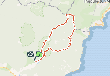
Tocht Stappen van 16,8 km beschikbaar op Provence-Alpes-Côte d'Azur, Var, Saint-Raphaël. Deze tocht wordt voorgesteld door donda.
Beschrijving
Parking de Belle Barbe - Baisse Oriental - Baisse des Sangliers - Col des Lentisques - Pic de l'Ours - Col Notre Dame - Sommet des Peties et Grosses Grues - Col de la Cadière - Ravin de la Cadière - Ravin de la Couche de L'Ane - retour par la piste du Mal Infernet.
Plaatsbepaling
Opmerkingen
Wandeltochten in de omgeving
![Tocht Stappen Saint-Raphaël - Sommet du Bonnet de Capelan - Photo](https://media.geolcdn.com/t/375/260/05863c9a-49da-4f41-9bfb-5d37c8a1781d.jpg&format=jpg&maxdim=2)
![Stappen Stappen](https://static1.geolcdn.com/sitytour/trail-icons/101.png)
Stappen
![](/images/other/stat-length.png)
![](https://static1.geolcdn.com/siteimages/upload/files/16400158638029165_repeat_loop_refresh_sync_direction_icon.png)
![Tocht Stappen Saint-Raphaël - Massif d'ésterel-grande boucle pic cap roux - Photo](https://media.geolcdn.com/t/375/260/75f5531d-898d-4f51-8086-6652c6aad722.jpg&format=jpg&maxdim=2)
![Stappen Stappen](https://static1.geolcdn.com/sitytour/trail-icons/101.png)
Stappen
![](/images/other/stat-length.png)
![](https://static1.geolcdn.com/siteimages/upload/files/16400158638029165_repeat_loop_refresh_sync_direction_icon.png)
![Tocht Stappen Saint-Raphaël - Les lacs par les rochers du Caneiret - Photo](https://media.geolcdn.com/t/375/260/cddead80-47f3-4091-93b3-1398b473dc08.jpg&format=jpg&maxdim=2)
![Stappen Stappen](https://static1.geolcdn.com/sitytour/trail-icons/101.png)
Stappen
![](/images/other/stat-length.png)
![](https://static1.geolcdn.com/siteimages/upload/files/16400158638029165_repeat_loop_refresh_sync_direction_icon.png)
![Tocht Stappen Saint-Raphaël - le Dramont - Photo](https://media.geolcdn.com/t/375/260/83d1f287-d047-452c-844a-302c6891c476.jpg&format=jpg&maxdim=2)
![Stappen Stappen](https://static1.geolcdn.com/sitytour/trail-icons/101.png)
Stappen
![](/images/other/stat-length.png)
![](https://static1.geolcdn.com/siteimages/upload/files/16400158638029165_repeat_loop_refresh_sync_direction_icon.png)
![Tocht Stappen Saint-Raphaël - Le tour du Pic du Cap Roux - St Raphaël (Agay) - Photo](https://media.geolcdn.com/t/375/260/ext.jpg?maxdim=2&url=https%3A%2F%2Fservices.sitytrail.com%2FGeolivesWS%2FDownloadMedia.ashx%3FTrailID%3D317929%26Media%3D17353_6.jpg)
![Stappen Stappen](https://static1.geolcdn.com/sitytour/trail-icons/101.png)
Stappen
![](/images/other/stat-length.png)
![](https://static1.geolcdn.com/siteimages/upload/files/16400158638029165_repeat_loop_refresh_sync_direction_icon.png)
![Tocht Stappen Saint-Raphaël - Pic du Cap Roux - Photo](https://media.geolcdn.com/t/375/260/ext.jpg?maxdim=2&url=https%3A%2F%2Fservices.sitytrail.com%2FGeolivesWS%2FDownloadMedia.ashx%3FTrailID%3D230669%26Media%3Dfix__20131103111411.jpg)
![Stappen Stappen](https://static1.geolcdn.com/sitytour/trail-icons/101.png)
Stappen
![](/images/other/stat-length.png)
![](https://static1.geolcdn.com/siteimages/upload/files/16400158638029165_repeat_loop_refresh_sync_direction_icon.png)
![Tocht Stappen Saint-Raphaël - SityTrail - ND - Aiguille - Photo](https://media.geolcdn.com/t/375/260/ext.jpg?maxdim=2&url=https%3A%2F%2Fstatic1.geolcdn.com%2Fsiteimages%2Fupload%2Ffiles%2F1553511878bg_sport_marche.png)
![Stappen Stappen](https://static1.geolcdn.com/sitytour/trail-icons/101.png)
Stappen
![](/images/other/stat-length.png)
![](https://static1.geolcdn.com/siteimages/upload/files/16400158638029165_repeat_loop_refresh_sync_direction_icon.png)
![Tocht Stappen Saint-Raphaël - Agay - Sainte-Barbe - Étang des Nénuphares - Photo](https://media.geolcdn.com/t/375/260/dfb7073a-02d4-4811-84ba-99dc2878a0d2.jpg&format=jpg&maxdim=2)
![Stappen Stappen](https://static1.geolcdn.com/sitytour/trail-icons/101.png)
Stappen
![](/images/other/stat-length.png)
![](https://static1.geolcdn.com/siteimages/upload/files/16400158638029165_repeat_loop_refresh_sync_direction_icon.png)
![Tocht Stappen Saint-Raphaël - Tour du Pic de l'Ours - Le Trayas - Photo](https://media.geolcdn.com/t/375/260/ext.jpg?maxdim=2&url=https%3A%2F%2Fservices.sitytrail.com%2FGeolivesWS%2FDownloadMedia.ashx%3FTrailID%3D191486%26Media%3D15078_2.jpg)
![Stappen Stappen](https://static1.geolcdn.com/sitytour/trail-icons/101.png)
Stappen
![](/images/other/stat-length.png)
![](https://static1.geolcdn.com/siteimages/upload/files/16400158638029165_repeat_loop_refresh_sync_direction_icon.png)