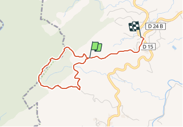
![](/images/other/stat-length.png)
![Tocht Stappen Sainte-Marie - Forêt de Reculée, boucle - Photo](https://media.geolcdn.com/t/1900/400/3e96e24f-6ea2-4688-80d7-3336ffaada83.jpg&format=pjpeg&maxdim=2)
Forêt de Reculée, boucle
Lamartiniere
Gebruiker GUIDE
![Lengte](/images/other/stat-length.png)
![Max. hoogte](https://static1.geolcdn.com/siteimages/upload/files/1508320355ic_sort_altitude_max_24dp.png)
![Positief hoogteverschil](https://static1.geolcdn.com/siteimages/upload/files/1508320355ic_sort_den_pos_24dp.png)
![Km-Effort](/images/other/stat-length.png)
![Min. hoogte](https://static1.geolcdn.com/siteimages/upload/files/1508320355ic_sort_altitude_min_24dp.png)
![Negatief hoogteverschil](https://static1.geolcdn.com/siteimages/upload/files/1508320355ic_sort_den_neg_24dp.png)
![Boucle](https://static1.geolcdn.com/siteimages/upload/files/16400158638029165_repeat_loop_refresh_sync_direction_icon.png)
![Stappen](https://static1.geolcdn.com/sitytour/trail-icons/101.png)
1h17
Moeilijkheid : Medium
![Scan deze QR-code om de tocht te openen in de SityTrail-applicatie](https://capi.geolives.com/qq0zvz2zws4bq2lad0pu/sitytour/trails/3009842/qr.png?size=200)
Gratisgps-wandelapplicatie
Over ons
Tocht Stappen van 4,8 km beschikbaar op Martinique, Onbekend, Sainte-Marie. Deze tocht wordt voorgesteld door Lamartiniere.
Beschrijving
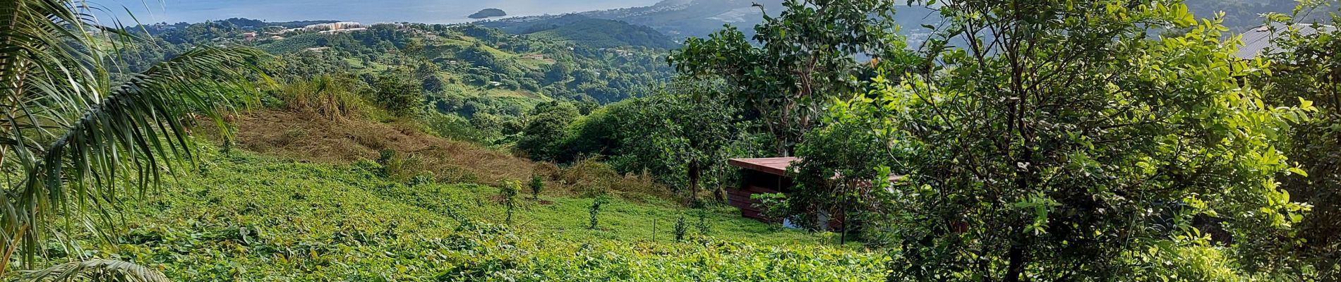
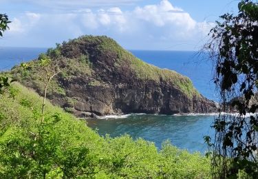
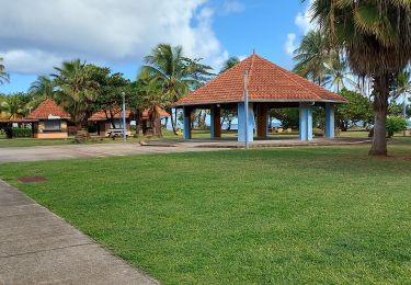
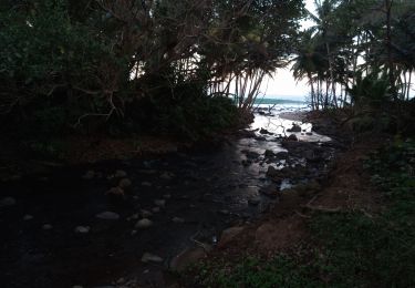
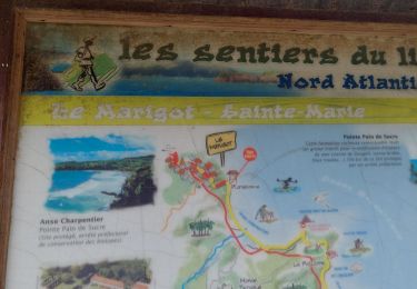
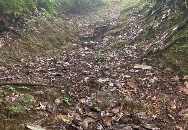
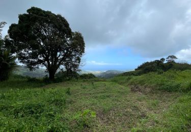
Départ et retour près la maison du Bèlé. Randonnée en boucle de 6 kms environ en forêt hydrophile idéale pour écoliers, séniors, touristes, autres marcheurs. Cette petite marche au relief varié, permet à tous un chacun dans un premier temps, de découvrir et de se familiariser avec une grande variéte d' essences sur cette portion de forêt humide, dans un second, en sortie de forêt, de contempler quelques panoramas de la ville de Ste Marie, de la Caravelle et autres massifs avoisinants, sans oublier, dans le parcours, les jardins aux légumes variés, ignames, dachines, gombos, concombres, pois d'angole, frabrication de charbon de bois, élevage et d'autres.... (J'ai enrégistré au niveau de la patte d'oie, donc il manque environ 1.2 kms.)
Plaatsbepaling
Opmerkingen
Wandeltochten in de omgeving
![Tocht Stappen Sainte-Marie - Ste Marie vers Marigot - Photo](https://media.geolcdn.com/t/375/260/2b09671f-5a24-4799-aa61-8da40f2e65c1.jpg&format=jpg&maxdim=2)
![Stappen Stappen](https://static1.geolcdn.com/sitytour/trail-icons/101.png)
Stappen
![](/images/other/stat-length.png)
![](https://static1.geolcdn.com/siteimages/upload/files/16400158638029165_repeat_loop_refresh_sync_direction_icon.png)
![Tocht Stappen Le Lorrain - Morne Jacob au Panneau ONF - Photo](https://media.geolcdn.com/t/375/260/54159292-758e-4621-a73f-109fb913bb31.jpg&format=jpg&maxdim=2)
![Stappen Stappen](https://static1.geolcdn.com/sitytour/trail-icons/101.png)
Stappen
![](/images/other/stat-length.png)
![](https://static1.geolcdn.com/siteimages/upload/files/16400158638029165_repeat_loop_refresh_sync_direction_icon.png)
![Tocht Stappen Sainte-Marie - Boucle Forêt de Reculée - Photo](https://media.geolcdn.com/t/375/260/75dddc71-d3e1-4bc1-9d56-791d6ffe8ae4.jpg&format=jpg&maxdim=2)
![Stappen Stappen](https://static1.geolcdn.com/sitytour/trail-icons/101.png)
Stappen
![](/images/other/stat-length.png)
![](https://static1.geolcdn.com/siteimages/upload/files/16400158638029165_repeat_loop_refresh_sync_direction_icon.png)
![Tocht Stappen Sainte-Marie - Boucle Place Clarissa JP via Musée de la Banane - Photo](https://media.geolcdn.com/t/375/260/bc80034b-5433-411a-ab7b-87d02096c2c6.jpg&format=jpg&maxdim=2)
![Stappen Stappen](https://static1.geolcdn.com/sitytour/trail-icons/101.png)
Stappen
![](/images/other/stat-length.png)
![](https://static1.geolcdn.com/siteimages/upload/files/16400158638029165_repeat_loop_refresh_sync_direction_icon.png)
![Tocht Stappen Sainte-Marie - Anse Charpentier - Anse Madame - Photo](https://media.geolcdn.com/t/375/260/ad81f2ea-9d64-49ad-a6d3-bb9f3f48d02b.jpg&format=jpg&maxdim=2)
![Stappen Stappen](https://static1.geolcdn.com/sitytour/trail-icons/101.png)
Stappen
![](/images/other/stat-length.png)
![](https://static1.geolcdn.com/siteimages/upload/files/16400158638029165_repeat_loop_refresh_sync_direction_icon.png)
![Tocht Trail Sainte-Marie - Sainte Marie- Marigot via la forêt La Philippe - Photo](https://media.geolcdn.com/t/375/260/6c8851e7-572f-40df-ad68-e806148d3977.jpg&format=jpg&maxdim=2)
![Trail Trail](https://static1.geolcdn.com/sitytour/trail-icons/104.png)
Trail
![](/images/other/stat-length.png)
![](https://static1.geolcdn.com/siteimages/upload/files/16400158638029165_repeat_loop_refresh_sync_direction_icon.png)
![Tocht Noords wandelen Sainte-Marie - Autour des 3 sources - Sainte Marie - Photo](https://media.geolcdn.com/t/375/260/111cc3d5-ab99-4f4b-93b1-05c3c44b5e59.jpg&format=jpg&maxdim=2)
![Noords wandelen Noords wandelen](https://static1.geolcdn.com/sitytour/trail-icons/102.png)
Noords wandelen
![](/images/other/stat-length.png)
![](https://static1.geolcdn.com/siteimages/upload/files/16400158638029165_repeat_loop_refresh_sync_direction_icon.png)
![Tocht Trail Sainte-Marie - Raid bèlè - - Photo](https://media.geolcdn.com/t/375/260/a390bc92-348d-45ca-b0bc-871e4c0a19b6.jpg&format=jpg&maxdim=2)
![Trail Trail](https://static1.geolcdn.com/sitytour/trail-icons/104.png)
Trail
![](/images/other/stat-length.png)
![](https://static1.geolcdn.com/siteimages/upload/files/16400158638029165_repeat_loop_refresh_sync_direction_icon.png)
![Tocht Stappen Sainte-Marie - Parcours Forêt de Reculée - Photo](https://media.geolcdn.com/t/375/260/79dee7af-d968-4909-b660-af6858f0b311.jpg&format=jpg&maxdim=2)
![Stappen Stappen](https://static1.geolcdn.com/sitytour/trail-icons/101.png)
Stappen
![](/images/other/stat-length.png)
![](https://static1.geolcdn.com/siteimages/upload/files/16400158638029165_repeat_loop_refresh_sync_direction_icon.png)