Tocht Lopen Rians - rians - Photo
 levequejef
levequejef

Gebruiker

© OpenStreetMap contributors
Lengte
Lengte
22 km
Max. hoogte
Max. hoogte
214 m
Positief hoogteverschil
190 m
Km-Effort
Km-Effort  
24 km
Min. hoogte
Min. hoogte
159 m
Negatief hoogteverschil
190 m
Boucle
Boucle
Ja
Datum van aanmaak :
2021-11-14 06:52:52.517
Laatste wijziging :
2021-11-14 10:07:23.416

(0 Bericht)

Lopen
Lopen
2h57
Moeilijkheid : Gemakkelijk

Scan deze QR-code om de tocht te openen in de SityTrail-applicatie

Gratisgps-wandelapplicatie

Logo SityTrail SityTrail

IGN / Geografische instituten

SityTrail uit de App Store downloaden SityTrail uit Google Play downloaden

Logo SityTrail SityTrail World

De wereld gaat voor u open

SityTrail uit de App Store downloaden SityTrail uit Google Play downloaden SityTrail op Huawei AppGallery downloaden

Over ons

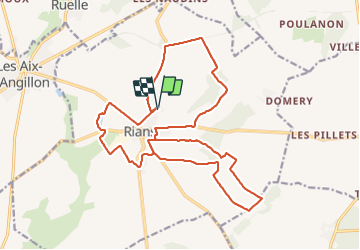
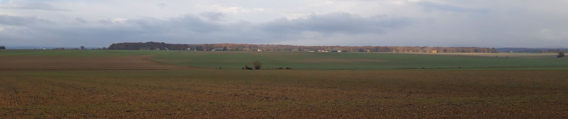
Tocht Lopen van 22 km beschikbaar op Centre-Val de Loire, Cher, Rians. Deze tocht wordt voorgesteld door levequejef.

Hoogteprofiel

Foto's

Plaatsbepaling

Land:
France
Regio :
Centre-Val de Loire
Departement/Provincie :
Cher
Gemeente :
Rians
Locatie:
Unknown
Vertrek:(UTM)
471177 ; 5226435 (31T) N.

Wandeltochten in de omgeving

Tocht Mountainbike Les Aix-d'Angillon - Menetou - Sancerroise - 1ère édition Juillet 2010 - Photo
Mountainbike
tracegps

Mountainbike

Moeilijk
Les Aix-d'Angillon, Centre-Val de Loire, Cher, France
80 km | 100 km-effort
6h 30min
Ja
Tocht Fiets Les Aix-d'Angillon - Menetou Sancerroise 50km - Photo
Fiets
mokmok18

Fiets

Medium
Les Aix-d'Angillon, Centre-Val de Loire, Cher, France
50 km | 60 km-effort
3h 25min
Ja
Tocht Fiets Les Aix-d'Angillon - Menetou sancerroise - Photo
Fiets
mokmok18

Fiets

Zeer moeilijk
Les Aix-d'Angillon, Centre-Val de Loire, Cher, France
90 km | 115 km-effort
6h 40min
Ja
Tocht Mountainbike Les Aix-d'Angillon - Menetou sancerroise 70km - Photo
Mountainbike
mokmok18

Mountainbike

Moeilijk
Les Aix-d'Angillon, Centre-Val de Loire, Cher, France
71 km | 87 km-effort
5h 36min
Ja
Tocht Mountainbike Les Aix-d'Angillon - Coteaux de Morogues 2011 - Les Aix d'Angillon - Photo
Mountainbike
tracegps

Mountainbike

Moeilijk
Les Aix-d'Angillon, Centre-Val de Loire, Cher, France
40 km | 51 km-effort
3h 0min
Ja
Tocht Stappen Les Aix-d'Angillon - Coteaux de Morogues 2011 - Les Aix d'Angillon - Photo
Stappen
tracegps

Stappen

Moeilijk
Les Aix-d'Angillon, Centre-Val de Loire, Cher, France
40 km | 51 km-effort
8h 0min
Ja
Tocht Lopen Rians - rians - Photo
Lopen
levequejef

Lopen

Medium
Rians, Centre-Val de Loire, Cher, France
22 km | 24 km-effort
3h 9min
Ja
Tocht sport Saint-Céols -  - Photo
sport
Jjlerat

sport

Heel gemakkelijk
Saint-Céols, Centre-Val de Loire, Cher, France
12,8 km | 14,8 km-effort
Onbekend
Ja
Tocht Stappen Aubinges - Aubinges - Photo
Stappen
jlrayon

Stappen

Heel gemakkelijk
Aubinges, Centre-Val de Loire, Cher, France
11,1 km | 13,2 km-effort
2h 53min
Ja


Sluiten
Mijn abonnementen