![](/images/other/stat-length.png)
![Tocht Stappen Aat - ISIERES _ Marche Fédérale _ HT _11/11/2021 - Photo](https://media.geolcdn.com/t/1900/400/ext.pjpeg?maxdim=2&url=https%3A%2F%2Fstatic1.geolcdn.com%2Fsiteimages%2Fupload%2Ffiles%2F1553511878bg_sport_marche.png)
ISIERES _ Marche Fédérale _ HT _11/11/2021
jeangulu
Gebruiker
![Lengte](/images/other/stat-length.png)
Lengte
21 km
![Boucle](https://static1.geolcdn.com/siteimages/upload/files/16400158638029165_repeat_loop_refresh_sync_direction_icon.png)
Boucle
Ja
Datum van aanmaak :
2021-11-11 09:22:02.942
Laatste wijziging :
2021-11-11 14:44:03.413
![Stappen](https://static1.geolcdn.com/sitytour/trail-icons/101.png)
5h21
Moeilijkheid : Gemakkelijk
![Scan deze QR-code om de tocht te openen in de SityTrail-applicatie](https://capi.geolives.com/qq0zvz2zws4bq2lad0pu/sitytour/trails/2999352/qr.png?size=200)
Gratisgps-wandelapplicatie
Over ons
Tocht Stappen van 21 km beschikbaar op Wallonië, Henegouwen, Aat. Deze tocht wordt voorgesteld door jeangulu.
Beschrijving
Point de départ : École Communale d'Isère - Place d'Isiéres, 13 -13 - 7822 ISIERES
Organisateur : HT 004 - LES AMIS DE LA NATURE ATH ASBL
Plaatsbepaling
Land:
Belgium
Regio :
Wallonië
Departement/Provincie :
Henegouwen
Gemeente :
Aat
Locatie:
Unknown
Vertrek:(Dec)
Vertrek:(UTM)
557971 ; 5612606 (31U) N.
Opmerkingen
Wandeltochten in de omgeving
![Tocht Stappen Aat - GG2-Ha-26_Ath-Erbisoeul_2021-11-04 - Photo](https://media.geolcdn.com/t/375/260/92330c27-b822-40ac-9b26-3b2e2e0e14fe.jpg&format=jpg&maxdim=2)
![Stappen Stappen](https://static1.geolcdn.com/sitytour/trail-icons/101.png)
GG2-Ha-26_Ath-Erbisoeul_2021-11-04
Stappen
Medium
(1)
Aat,
Wallonië,
Henegouwen,
Belgium
![](/images/other/stat-length.png)
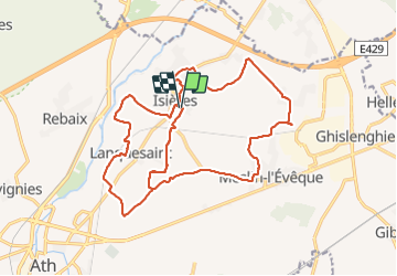
24 km | 26 km-effort
5h 59min
![](https://static1.geolcdn.com/siteimages/upload/files/16400158638029165_repeat_loop_refresh_sync_direction_icon.png)
Neen
![Tocht Te voet Aat - Kastelenroute - Photo](https://media.geolcdn.com/t/375/260/ext.jpg?maxdim=2&url=https%3A%2F%2Fpivotmedia.tourismewallonie.be%2FANX-02-04JL-028B%2FANX-02-04JL-028B.JPG)
![Te voet Te voet](https://static1.geolcdn.com/sitytour/trail-icons/100.png)
Kastelenroute
Te voet
Gemakkelijk
Aat,
Wallonië,
Henegouwen,
Belgium
![](/images/other/stat-length.png)
15 km | 16,5 km-effort
3h 45min
![](https://static1.geolcdn.com/siteimages/upload/files/16400158638029165_repeat_loop_refresh_sync_direction_icon.png)
Ja
![Tocht Te voet Aat - De Ronde van de Blanc Moulin - Photo](https://media.geolcdn.com/t/375/260/ext.jpg?maxdim=2&url=https%3A%2F%2Fpivotmedia.tourismewallonie.be%2FANX-02-000ELT%2FANX-02-000ELT.jpg)
![Te voet Te voet](https://static1.geolcdn.com/sitytour/trail-icons/100.png)
De Ronde van de Blanc Moulin
Te voet
Gemakkelijk
(1)
Aat,
Wallonië,
Henegouwen,
Belgium
![](/images/other/stat-length.png)
7,1 km | 7,7 km-effort
1h 44min
![](https://static1.geolcdn.com/siteimages/upload/files/16400158638029165_repeat_loop_refresh_sync_direction_icon.png)
Ja
![Tocht Te voet Aat - Het Molencircuit - Photo](https://media.geolcdn.com/t/375/260/ext.jpg?maxdim=2&url=https%3A%2F%2Fpivotmedia.tourismewallonie.be%2FANX-02-000EOC%2FANX-02-000EOC.jpg)
![Te voet Te voet](https://static1.geolcdn.com/sitytour/trail-icons/100.png)
Het Molencircuit
Te voet
Medium
Aat,
Wallonië,
Henegouwen,
Belgium
![](/images/other/stat-length.png)
19,4 km | 22 km-effort
4h 54min
![](https://static1.geolcdn.com/siteimages/upload/files/16400158638029165_repeat_loop_refresh_sync_direction_icon.png)
Ja
![Tocht Te voet Aat - Circuit van de Dendervlakte - Photo](https://media.geolcdn.com/t/375/260/ext.jpg?maxdim=2&url=https%3A%2F%2Fpivotmedia.tourismewallonie.be%2FANX-02-000ESY%2FANX-02-000ESY.jpg)
![Te voet Te voet](https://static1.geolcdn.com/sitytour/trail-icons/100.png)
Circuit van de Dendervlakte
Te voet
Gemakkelijk
(1)
Aat,
Wallonië,
Henegouwen,
Belgium
![](/images/other/stat-length.png)
8,9 km | 9,7 km-effort
2h 12min
![](https://static1.geolcdn.com/siteimages/upload/files/16400158638029165_repeat_loop_refresh_sync_direction_icon.png)
Ja
![Tocht Te voet Aat - Het Kapellencircuit - Photo](https://media.geolcdn.com/t/375/260/ext.jpg?maxdim=2&url=https%3A%2F%2Fpivotmedia.tourismewallonie.be%2FANX-02-000EST%2FANX-02-000EST.jpg)
![Te voet Te voet](https://static1.geolcdn.com/sitytour/trail-icons/100.png)
Het Kapellencircuit
Te voet
Gemakkelijk
Aat,
Wallonië,
Henegouwen,
Belgium
![](/images/other/stat-length.png)
11,1 km | 12,3 km-effort
2h 47min
![](https://static1.geolcdn.com/siteimages/upload/files/16400158638029165_repeat_loop_refresh_sync_direction_icon.png)
Ja
![Tocht Te voet Lessen - Wandeling van](https://media.geolcdn.com/t/375/260/ext.jpg?maxdim=2&url=https%3A%2F%2Fpivotmedia.tourismewallonie.be%2FANX-02-04JQ-001F%2FANX-02-04JQ-001F.JPG)
![Te voet Te voet](https://static1.geolcdn.com/sitytour/trail-icons/100.png)
Wandeling van "l'Arbre de la Liberté"
Te voet
Gemakkelijk
Lessen,
Wallonië,
Henegouwen,
Belgium
![](/images/other/stat-length.png)
7,2 km | 8,4 km-effort
1h 54min
![](https://static1.geolcdn.com/siteimages/upload/files/16400158638029165_repeat_loop_refresh_sync_direction_icon.png)
Ja
![Tocht Te voet Lessen - Wandeling van Bois-de-Lessines - Photo](https://media.geolcdn.com/t/375/260/ext.jpg?maxdim=2&url=https%3A%2F%2Fpivotmedia.tourismewallonie.be%2FANX-02-04JP-008X%2FANX-02-04JP-008X.JPG)
![Te voet Te voet](https://static1.geolcdn.com/sitytour/trail-icons/100.png)
Wandeling van Bois-de-Lessines
Te voet
Gemakkelijk
Lessen,
Wallonië,
Henegouwen,
Belgium
![](/images/other/stat-length.png)
9,8 km | 11,4 km-effort
2h 36min
![](https://static1.geolcdn.com/siteimages/upload/files/16400158638029165_repeat_loop_refresh_sync_direction_icon.png)
Ja
![Tocht Te voet Lessen - Wandeling van het Château de l'Estriverie - Photo](https://media.geolcdn.com/t/375/260/ext.jpg?maxdim=2&url=https%3A%2F%2Fpivotmedia.tourismewallonie.be%2FANX-02-04JP-009M%2FANX-02-04JP-009M.JPG)
![Te voet Te voet](https://static1.geolcdn.com/sitytour/trail-icons/100.png)
Wandeling van het Château de l'Estriverie
Te voet
Gemakkelijk
(1)
Lessen,
Wallonië,
Henegouwen,
Belgium
![](/images/other/stat-length.png)
6,3 km | 7,3 km-effort
1h 39min
![](https://static1.geolcdn.com/siteimages/upload/files/16400158638029165_repeat_loop_refresh_sync_direction_icon.png)
Ja