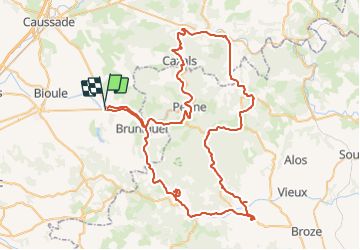
![](/images/other/stat-length.png)
![Tocht Auto Montricoux - Les Bastides Albigeoises-Puycelsi-Castelnau-St Antonin - Photo](https://media.geolcdn.com/t/1900/400/12225483-6426-45c4-9727-e792b76a9d9a.jpg&format=pjpeg&maxdim=2)
Les Bastides Albigeoises-Puycelsi-Castelnau-St Antonin
bernard_ostermann
Gebruiker
![Lengte](/images/other/stat-length.png)
![Max. hoogte](https://static1.geolcdn.com/siteimages/upload/files/1508320355ic_sort_altitude_max_24dp.png)
![Positief hoogteverschil](https://static1.geolcdn.com/siteimages/upload/files/1508320355ic_sort_den_pos_24dp.png)
![Km-Effort](/images/other/stat-length.png)
![Min. hoogte](https://static1.geolcdn.com/siteimages/upload/files/1508320355ic_sort_altitude_min_24dp.png)
![Negatief hoogteverschil](https://static1.geolcdn.com/siteimages/upload/files/1508320355ic_sort_den_neg_24dp.png)
![Boucle](https://static1.geolcdn.com/siteimages/upload/files/16400158638029165_repeat_loop_refresh_sync_direction_icon.png)
![Auto](https://static1.geolcdn.com/sitytour/trail-icons/401.png)
2h30
Moeilijkheid : Gemakkelijk
![Motorfiets](https://static1.geolcdn.com/sitytour/trail-icons/402.png)
2h30
Moeilijkheid : Gemakkelijk
![Scan deze QR-code om de tocht te openen in de SityTrail-applicatie](https://capi.geolives.com/qq0zvz2zws4bq2lad0pu/sitytour/trails/2997665/qr.png?size=200)
Gratisgps-wandelapplicatie
Over ons
Tocht Auto van 97 km beschikbaar op Occitanië, Tarn-et-Garonne, Montricoux. Deze tocht wordt voorgesteld door bernard_ostermann.
Beschrijving
Départ à Montricoux.
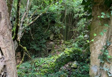
Passage au pied du château de Bruniquel, lieu de tournage du film "Le vieux fusil"
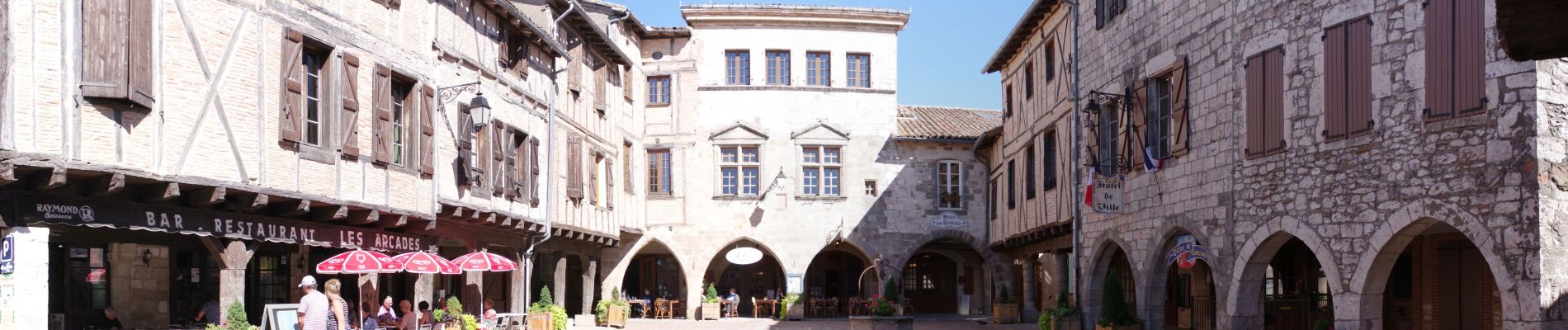
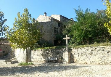
Passage par la bastide de Puycelsi suivie de celle de Castelnau-de-Montmiral dont la place des arcades est sublime.
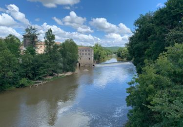
Retour en passant par Saint-Antonin-Noble-Val puis par la route de la corniche surplombant la vallée de l'Aveyron.
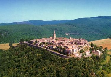
Suivi de la vallée de l'Aveyron jusqu'à Penne dont le château est construit sur une barre rocheuse spectaculaire.
Plaatsbepaling
Opmerkingen
Wandeltochten in de omgeving
![Tocht Mountainbike Bruniquel - Bruniquel, Grésigne, Penne - Photo](https://media.geolcdn.com/t/375/260/ext.jpg?maxdim=2&url=https%3A%2F%2Fservices.sitytrail.com%2FGeolivesWS%2FDownloadMedia.ashx%3FTrailID%3D100894%26Media%3D395_2.jpg)
![Mountainbike Mountainbike](https://static1.geolcdn.com/sitytour/trail-icons/202.png)
Mountainbike
![](/images/other/stat-length.png)
![](https://static1.geolcdn.com/siteimages/upload/files/16400158638029165_repeat_loop_refresh_sync_direction_icon.png)
![Tocht Stappen Bruniquel - Bruni quel - Photo](https://media.geolcdn.com/t/375/260/6fb8d380-d7d9-467c-88ab-637a210db92b.jpg&format=jpg&maxdim=2)
![Stappen Stappen](https://static1.geolcdn.com/sitytour/trail-icons/101.png)
Stappen
![](/images/other/stat-length.png)
![](https://static1.geolcdn.com/siteimages/upload/files/16400158638029165_repeat_loop_refresh_sync_direction_icon.png)
![Tocht Stappen Montricoux - Montricoux - Photo](https://media.geolcdn.com/t/375/260/2655e387-e67f-4901-a5a8-004800180e9a.jpg&format=jpg&maxdim=2)
![Stappen Stappen](https://static1.geolcdn.com/sitytour/trail-icons/101.png)
Stappen
![](/images/other/stat-length.png)
![](https://static1.geolcdn.com/siteimages/upload/files/16400158638029165_repeat_loop_refresh_sync_direction_icon.png)
![Tocht Mountainbike Bruniquel - Rando VTT Boucle Bruniquel - Foret de Bretou - Photo](https://media.geolcdn.com/t/375/260/ext.jpg?maxdim=2&url=https%3A%2F%2Fstatic1.geolcdn.com%2Fsiteimages%2Fupload%2Ffiles%2F1524743154velo.jpg)
![Mountainbike Mountainbike](https://static1.geolcdn.com/sitytour/trail-icons/202.png)
Mountainbike
![](/images/other/stat-length.png)
![](https://static1.geolcdn.com/siteimages/upload/files/16400158638029165_repeat_loop_refresh_sync_direction_icon.png)
![Tocht Andere activiteiten Bruniquel - bruniquel - Photo](https://media.geolcdn.com/t/375/260/ext.jpg?maxdim=2&url=https%3A%2F%2Fservices.sitytrail.com%2FGeolivesWS%2FDownloadMedia.ashx%3FTrailID%3D351615%26Media%3Dfix__20141003155114.jpg)
![Andere activiteiten Andere activiteiten](https://static1.geolcdn.com/sitytour/trail-icons/900.png)
Andere activiteiten
![](/images/other/stat-length.png)
![](https://static1.geolcdn.com/siteimages/upload/files/16400158638029165_repeat_loop_refresh_sync_direction_icon.png)
![Tocht Mountainbike Bruniquel - VTT à Bruniquel - Photo](https://media.geolcdn.com/t/375/260/ext.jpg?maxdim=2&url=https%3A%2F%2Fstatic1.geolcdn.com%2Fsiteimages%2Fupload%2Ffiles%2F1524743154velo.jpg)
![Mountainbike Mountainbike](https://static1.geolcdn.com/sitytour/trail-icons/202.png)
Mountainbike
![](/images/other/stat-length.png)
![](https://static1.geolcdn.com/siteimages/upload/files/16400158638029165_repeat_loop_refresh_sync_direction_icon.png)
![Tocht Te voet Montricoux - Montricoux - Photo](https://media.geolcdn.com/t/375/260/ext.jpg?maxdim=2&url=https%3A%2F%2Fstatic1.geolcdn.com%2Fsiteimages%2Fupload%2Ffiles%2F1545311037marcheuse_200dpi.jpg)
![Te voet Te voet](https://static1.geolcdn.com/sitytour/trail-icons/100.png)
Te voet
![](/images/other/stat-length.png)
![](https://static1.geolcdn.com/siteimages/upload/files/16400158638029165_repeat_loop_refresh_sync_direction_icon.png)
![Tocht Stappen Bruniquel - bruniquel PR9 les rênes - Photo](https://media.geolcdn.com/t/375/260/583f8d15-0fba-48ac-97ed-43ca7eec6f0a.jpg&format=jpg&maxdim=2)
![Stappen Stappen](https://static1.geolcdn.com/sitytour/trail-icons/101.png)
Stappen
![](/images/other/stat-length.png)
![](https://static1.geolcdn.com/siteimages/upload/files/16400158638029165_repeat_loop_refresh_sync_direction_icon.png)
![Tocht Elektrische fiets Bruniquel - Puycelsi - Castelnau de Montmiral - Photo](https://media.geolcdn.com/t/375/260/70f6747f-2ec6-44e9-97fc-acc6eeac731a.jpg&format=jpg&maxdim=2)
![Elektrische fiets Elektrische fiets](https://static1.geolcdn.com/sitytour/trail-icons/205.png)
Elektrische fiets
![](/images/other/stat-length.png)
![](https://static1.geolcdn.com/siteimages/upload/files/16400158638029165_repeat_loop_refresh_sync_direction_icon.png)