![](/images/other/stat-length.png)
![Tocht Stappen La Chapelle-Rablais - Forêt de Villefermoy - Boucle Sud - Photo](https://media.geolcdn.com/t/1900/400/62bd6420-341b-4726-a7bb-20697bc5d547.jpg&format=pjpeg&maxdim=2)
Forêt de Villefermoy - Boucle Sud
Les 1000 pattes
Club randonnées SERVON
![Lengte](/images/other/stat-length.png)
Lengte
19,6 km
![Max. hoogte](https://static1.geolcdn.com/siteimages/upload/files/1508320355ic_sort_altitude_max_24dp.png)
Max. hoogte
143 m
![Positief hoogteverschil](https://static1.geolcdn.com/siteimages/upload/files/1508320355ic_sort_den_pos_24dp.png)
Positief hoogteverschil
113 m
![Km-Effort](/images/other/stat-length.png)
Km-Effort
21 km
![Min. hoogte](https://static1.geolcdn.com/siteimages/upload/files/1508320355ic_sort_altitude_min_24dp.png)
Min. hoogte
113 m
![Negatief hoogteverschil](https://static1.geolcdn.com/siteimages/upload/files/1508320355ic_sort_den_neg_24dp.png)
Negatief hoogteverschil
113 m
![Boucle](https://static1.geolcdn.com/siteimages/upload/files/16400158638029165_repeat_loop_refresh_sync_direction_icon.png)
Boucle
Ja
Datum van aanmaak :
2021-11-08 10:40:34.619
Laatste wijziging :
2021-12-14 13:17:09.9
![Stappen](https://static1.geolcdn.com/sitytour/trail-icons/101.png)
3h27
Moeilijkheid : Moeilijk
![Scan deze QR-code om de tocht te openen in de SityTrail-applicatie](https://capi.geolives.com/qq0zvz2zws4bq2lad0pu/sitytour/trails/2996088/qr.png?size=200)
Gratisgps-wandelapplicatie
Over ons
Tocht Stappen van 19,6 km beschikbaar op Île-de-France, Seine-et-Marne, La Chapelle-Rablais. Deze tocht wordt voorgesteld door Les 1000 pattes.
Beschrijving
Parking de la Mairie Rue de la Mare à la Cane à La chapelle Rablais
Trajet Servon-->La Chapelle Rablais (46km: 36mn)
Plaatsbepaling
Land:
France
Regio :
Île-de-France
Departement/Provincie :
Seine-et-Marne
Gemeente :
La Chapelle-Rablais
Locatie:
Unknown
Vertrek:(Dec)
Vertrek:(UTM)
497807 ; 5373251 (31U) N.
Opmerkingen
Wandeltochten in de omgeving
![Tocht Stappen Fontenailles - Les vallons de Fontenailles - Photo](https://media.geolcdn.com/t/375/260/25c28c20-59d3-48bc-849f-b1de09e21cc2.jpg&format=jpg&maxdim=2)
![Stappen Stappen](https://static1.geolcdn.com/sitytour/trail-icons/101.png)
Les vallons de Fontenailles
Stappen
Fontenailles,
Île-de-France,
Seine-et-Marne,
France
![](/images/other/stat-length.png)
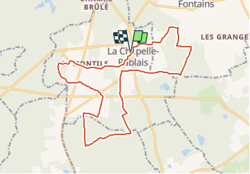
8,1 km | 9,4 km-effort
Onbekend
![](https://static1.geolcdn.com/siteimages/upload/files/16400158638029165_repeat_loop_refresh_sync_direction_icon.png)
Ja
![Tocht Stappen Fontenailles - Villefermoy - Photo](https://media.geolcdn.com/t/375/260/6e596718-3977-45ab-b48e-962eb2b8b1b2.jpg&format=jpg&maxdim=2)
![Stappen Stappen](https://static1.geolcdn.com/sitytour/trail-icons/101.png)
Villefermoy
Stappen
Medium
Fontenailles,
Île-de-France,
Seine-et-Marne,
France
![](/images/other/stat-length.png)
14,9 km | 16,4 km-effort
3h 10min
![](https://static1.geolcdn.com/siteimages/upload/files/16400158638029165_repeat_loop_refresh_sync_direction_icon.png)
Ja
![Tocht Stappen Fontenailles - BMF-161029 - Fontenailles-ChapelleGauthier - Photo](https://media.geolcdn.com/t/375/260/ext.jpg?maxdim=2&url=https%3A%2F%2Fservices.sitytrail.com%2FGeolivesWS%2FDownloadMedia.ashx%3FTrailID%3D653840%26Media%3Dfix__20161029121925.jpg)
![Stappen Stappen](https://static1.geolcdn.com/sitytour/trail-icons/101.png)
BMF-161029 - Fontenailles-ChapelleGauthier
Stappen
Heel gemakkelijk
Fontenailles,
Île-de-France,
Seine-et-Marne,
France
![](/images/other/stat-length.png)
16 km | 18,3 km-effort
5h 30min
![](https://static1.geolcdn.com/siteimages/upload/files/16400158638029165_repeat_loop_refresh_sync_direction_icon.png)
Ja
![Tocht Stappen Fontenailles - contreforts-de-la-for-t-de-villefermoy - Photo](https://media.geolcdn.com/t/375/260/ext.jpg?maxdim=2&url=https%3A%2F%2Fstatic1.geolcdn.com%2Fsiteimages%2Fupload%2Ffiles%2F1553511878bg_sport_marche.png)
![Stappen Stappen](https://static1.geolcdn.com/sitytour/trail-icons/101.png)
contreforts-de-la-for-t-de-villefermoy
Stappen
Moeilijk
Fontenailles,
Île-de-France,
Seine-et-Marne,
France
![](/images/other/stat-length.png)
23 km | 26 km-effort
6h 0min
![](https://static1.geolcdn.com/siteimages/upload/files/16400158638029165_repeat_loop_refresh_sync_direction_icon.png)
Ja
![Tocht Stappen La Chapelle-Rablais - Forêt de Villefermoy - Boucle Sud - Photo](https://media.geolcdn.com/t/375/260/ext.jpg?maxdim=2&url=https%3A%2F%2Fstatic1.geolcdn.com%2Fsiteimages%2Fupload%2Ffiles%2F1553511878bg_sport_marche.png)
![Stappen Stappen](https://static1.geolcdn.com/sitytour/trail-icons/101.png)
Forêt de Villefermoy - Boucle Sud
Stappen
Medium
La Chapelle-Rablais,
Île-de-France,
Seine-et-Marne,
France
![](/images/other/stat-length.png)
14 km | 15,2 km-effort
3h 27min
![](https://static1.geolcdn.com/siteimages/upload/files/16400158638029165_repeat_loop_refresh_sync_direction_icon.png)
Ja
![Tocht Stappen La Chapelle-Rablais - LA CHAPELLE RABLAIS - SUR LES PAS DE THIBAUD DE CHAMPAGNE - Photo](https://media.geolcdn.com/t/375/260/ext.jpg?maxdim=2&url=https%3A%2F%2Fstatic1.geolcdn.com%2Fsiteimages%2Fupload%2Ffiles%2F1553511878bg_sport_marche.png)
![Stappen Stappen](https://static1.geolcdn.com/sitytour/trail-icons/101.png)
LA CHAPELLE RABLAIS - SUR LES PAS DE THIBAUD DE CHAMPAGNE
Stappen
Moeilijk
La Chapelle-Rablais,
Île-de-France,
Seine-et-Marne,
France
![](/images/other/stat-length.png)
15,7 km | 17 km-effort
3h 47min
![](https://static1.geolcdn.com/siteimages/upload/files/16400158638029165_repeat_loop_refresh_sync_direction_icon.png)
Ja
![Tocht Stappen La Chapelle-Gauthier - WP0001 - Photo](https://media.geolcdn.com/t/375/260/ext.jpg?maxdim=2&url=https%3A%2F%2Fstatic1.geolcdn.com%2Fsiteimages%2Fupload%2Ffiles%2F1553511878bg_sport_marche.png)
![Stappen Stappen](https://static1.geolcdn.com/sitytour/trail-icons/101.png)
WP0001
Stappen
Moeilijk
La Chapelle-Gauthier,
Île-de-France,
Seine-et-Marne,
France
![](/images/other/stat-length.png)
14,1 km | 15,8 km-effort
3h 50min
![](https://static1.geolcdn.com/siteimages/upload/files/16400158638029165_repeat_loop_refresh_sync_direction_icon.png)
Ja
![Tocht Stappen Fontenailles - Contreforts de la forêt de villefermoy - Photo](https://media.geolcdn.com/t/375/260/ext.jpg?maxdim=2&url=https%3A%2F%2Fstatic1.geolcdn.com%2Fsiteimages%2Fupload%2Ffiles%2F1553511878bg_sport_marche.png)
![Stappen Stappen](https://static1.geolcdn.com/sitytour/trail-icons/101.png)
Contreforts de la forêt de villefermoy
Stappen
Medium
Fontenailles,
Île-de-France,
Seine-et-Marne,
France
![](/images/other/stat-length.png)
23 km | 25 km-effort
5h 37min
![](https://static1.geolcdn.com/siteimages/upload/files/16400158638029165_repeat_loop_refresh_sync_direction_icon.png)
Ja
![Tocht Stappen Nangis - Nangis et Rampillon - Photo](https://media.geolcdn.com/t/375/260/ext.jpg?maxdim=2&url=https%3A%2F%2Fstatic1.geolcdn.com%2Fsiteimages%2Fupload%2Ffiles%2F1553511878bg_sport_marche.png)
![Stappen Stappen](https://static1.geolcdn.com/sitytour/trail-icons/101.png)
Nangis et Rampillon
Stappen
Zeer moeilijk
Nangis,
Île-de-France,
Seine-et-Marne,
France
![](/images/other/stat-length.png)
21 km | 23 km-effort
5h 10min
![](https://static1.geolcdn.com/siteimages/upload/files/16400158638029165_repeat_loop_refresh_sync_direction_icon.png)
Ja