![](/images/other/stat-length.png)
![Tocht Stappen Courmes - Grand tour du plateau de Saint Barnabé - Photo](https://media.geolcdn.com/t/1900/400/ext.pjpeg?maxdim=2&url=https%3A%2F%2Fmedia.geolcdn.com%2Ff%2F34a4b033-2400-4d6d-a097-311fcc2effc9.jpg)
Grand tour du plateau de Saint Barnabé
jlrayon
Gebruiker
![Lengte](/images/other/stat-length.png)
![Max. hoogte](https://static1.geolcdn.com/siteimages/upload/files/1508320355ic_sort_altitude_max_24dp.png)
![Positief hoogteverschil](https://static1.geolcdn.com/siteimages/upload/files/1508320355ic_sort_den_pos_24dp.png)
![Km-Effort](/images/other/stat-length.png)
![Min. hoogte](https://static1.geolcdn.com/siteimages/upload/files/1508320355ic_sort_altitude_min_24dp.png)
![Negatief hoogteverschil](https://static1.geolcdn.com/siteimages/upload/files/1508320355ic_sort_den_neg_24dp.png)
![Boucle](https://static1.geolcdn.com/siteimages/upload/files/16400158638029165_repeat_loop_refresh_sync_direction_icon.png)
![Stappen](https://static1.geolcdn.com/sitytour/trail-icons/101.png)
4h39
Moeilijkheid : Medium
![Scan deze QR-code om de tocht te openen in de SityTrail-applicatie](https://capi.geolives.com/qq0zvz2zws4bq2lad0pu/sitytour/trails/2993489/qr.png?size=200)
Gratisgps-wandelapplicatie
Over ons
Tocht Stappen van 10,8 km beschikbaar op Provence-Alpes-Côte d'Azur, Alpes-Maritimes, Courmes. Deze tocht wordt voorgesteld door jlrayon.
Beschrijving
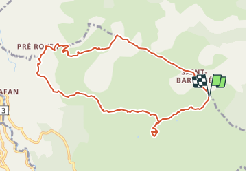
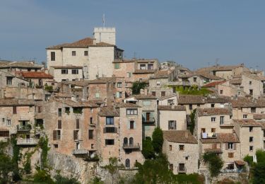
Grand tour du plateau de Saint Barnabé par la grotte de La Fumada, le Collet de Fréjus, le Pré Royer, l’Oratoire de La Baisse, visite du village pétrifié de la Sambre Brune et retour au parking.
(Trace de Rando effectuée le 5-11-2021)
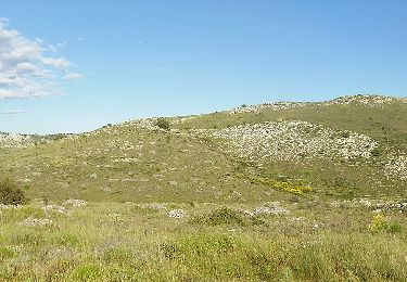
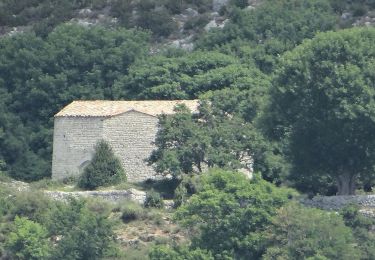
Situé à cheval sur les communes de Courmes et de Coursegoules le hameau de Saint Barnabé est entouré par un vaste plateau calcaire aride entouré de vallons verdoyant.
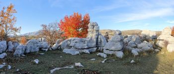
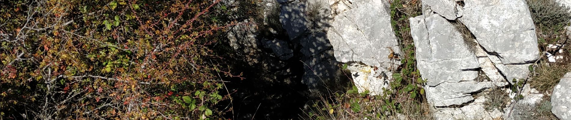
Cette rando permet d’en observer tous les aspects, les reliefs karstiques : dolines, avens, grottes, lapiaz, chaos, mais aussi des sous-bois de chênes et de pins et des garrigues, elle se termine par la visite de la Sambre Brune, un chaos ruiniforme faisant penser à village de trolls pétrifiés.
Plaatsbepaling
Opmerkingen
Wandeltochten in de omgeving
![Tocht Stappen Tourrettes-sur-Loup - Le Puy de Naouri 1024 m, depuis Tourrettes-sur-Loup - Photo](https://media.geolcdn.com/t/375/260/ext.jpg?maxdim=2&url=https%3A%2F%2Fservices.sitytrail.com%2FGeolivesWS%2FDownloadMedia.ashx%3FTrailID%3D214858%26Media%3D15396_1.jpg)
![Stappen Stappen](https://static1.geolcdn.com/sitytour/trail-icons/101.png)
Stappen
![](/images/other/stat-length.png)
![](https://static1.geolcdn.com/siteimages/upload/files/16400158638029165_repeat_loop_refresh_sync_direction_icon.png)
![Tocht Te voet Vence - Circuit des Blaquières - Photo](https://media.geolcdn.com/t/375/260/ext.jpg?maxdim=2&url=https%3A%2F%2Fmedia.geolcdn.com%2Ff%2F46014005-cf89-423b-a650-f449be44d3f6.jpeg)
![Te voet Te voet](https://static1.geolcdn.com/sitytour/trail-icons/100.png)
Te voet
![](/images/other/stat-length.png)
![](https://static1.geolcdn.com/siteimages/upload/files/16400158638029165_repeat_loop_refresh_sync_direction_icon.png)
![Tocht Te voet Tourrettes-sur-Loup - Circuit de Pié Martin - Photo](https://media.geolcdn.com/t/375/260/ext.jpg?maxdim=2&url=https%3A%2F%2Fmedia.geolcdn.com%2Ff%2F6e40e7c0-6b09-4a1a-a532-91e02b70ea94.jpeg)
![Te voet Te voet](https://static1.geolcdn.com/sitytour/trail-icons/100.png)
Te voet
![](/images/other/stat-length.png)
![](https://static1.geolcdn.com/siteimages/upload/files/16400158638029165_repeat_loop_refresh_sync_direction_icon.png)
![Tocht Te voet Coursegoules - Circuit du Viériou - Photo](https://media.geolcdn.com/t/375/260/ext.jpg?maxdim=2&url=https%3A%2F%2Fmedia.geolcdn.com%2Ff%2F033e2b9d-7778-4f86-857e-14601d59043a.jpeg)
![Te voet Te voet](https://static1.geolcdn.com/sitytour/trail-icons/100.png)
Te voet
![](/images/other/stat-length.png)
![](https://static1.geolcdn.com/siteimages/upload/files/16400158638029165_repeat_loop_refresh_sync_direction_icon.png)
![Tocht Te voet Gréolières - Traversée des Miroirs - Photo](https://media.geolcdn.com/t/375/260/ext.jpg?maxdim=2&url=https%3A%2F%2Fmedia.geolcdn.com%2Ff%2F273aae50-c65a-44a2-8836-25bdf1d17610.jpeg)
![Te voet Te voet](https://static1.geolcdn.com/sitytour/trail-icons/100.png)
Te voet
![](/images/other/stat-length.png)
![](https://static1.geolcdn.com/siteimages/upload/files/16400158638029165_repeat_loop_refresh_sync_direction_icon.png)
![Tocht Te voet Courmes - Plateau de Saint-Barnabé - Photo](https://media.geolcdn.com/t/375/260/ext.jpg?maxdim=2&url=https%3A%2F%2Fmedia.geolcdn.com%2Ff%2Fe5884674-6345-4525-aa20-82da8aac2558.jpeg)
![Te voet Te voet](https://static1.geolcdn.com/sitytour/trail-icons/100.png)
Te voet
![](/images/other/stat-length.png)
![](https://static1.geolcdn.com/siteimages/upload/files/16400158638029165_repeat_loop_refresh_sync_direction_icon.png)
![Tocht Te voet Vence - Circuit du Malvan - Photo](https://media.geolcdn.com/t/375/260/ext.jpg?maxdim=2&url=https%3A%2F%2Fmedia.geolcdn.com%2Ff%2Fa11b075b-d314-4d7d-9ea3-2c9f013025ba.jpeg)
![Te voet Te voet](https://static1.geolcdn.com/sitytour/trail-icons/100.png)
Te voet
![](/images/other/stat-length.png)
![](https://static1.geolcdn.com/siteimages/upload/files/16400158638029165_repeat_loop_refresh_sync_direction_icon.png)
![Tocht Te voet Vence - Plan des Noves - Photo](https://media.geolcdn.com/t/375/260/ext.jpg?maxdim=2&url=https%3A%2F%2Fmedia.geolcdn.com%2Ff%2F5bdbad17-ece4-4950-8e82-290491f5430d.jpeg)
![Te voet Te voet](https://static1.geolcdn.com/sitytour/trail-icons/100.png)
Te voet
![](/images/other/stat-length.png)
![](https://static1.geolcdn.com/siteimages/upload/files/16400158638029165_repeat_loop_refresh_sync_direction_icon.png)
![Tocht Te voet Tourrettes-sur-Loup - Puy de Naouri - Photo](https://media.geolcdn.com/t/375/260/ext.jpg?maxdim=2&url=https%3A%2F%2Fmedia.geolcdn.com%2Ff%2Fa11b075b-d314-4d7d-9ea3-2c9f013025ba.jpeg)
![Te voet Te voet](https://static1.geolcdn.com/sitytour/trail-icons/100.png)
Te voet
![](/images/other/stat-length.png)
![](https://static1.geolcdn.com/siteimages/upload/files/16400158638029165_repeat_loop_refresh_sync_direction_icon.png)