![](/images/other/stat-length.png)
![Tocht Stappen Pont-Audemer - Saint -Germain-Village 2021 10 31_ - Photo](https://media.geolcdn.com/t/1900/400/ext.pjpeg?maxdim=2&url=https%3A%2F%2Fstatic1.geolcdn.com%2Fsiteimages%2Fupload%2Ffiles%2F1553511878bg_sport_marche.png)
Saint -Germain-Village 2021 10 31_
phiber76
Gebruiker
![Lengte](/images/other/stat-length.png)
Lengte
19,2 km
![Max. hoogte](https://static1.geolcdn.com/siteimages/upload/files/1508320355ic_sort_altitude_max_24dp.png)
Max. hoogte
126 m
![Positief hoogteverschil](https://static1.geolcdn.com/siteimages/upload/files/1508320355ic_sort_den_pos_24dp.png)
Positief hoogteverschil
409 m
![Km-Effort](/images/other/stat-length.png)
Km-Effort
25 km
![Min. hoogte](https://static1.geolcdn.com/siteimages/upload/files/1508320355ic_sort_altitude_min_24dp.png)
Min. hoogte
13 m
![Negatief hoogteverschil](https://static1.geolcdn.com/siteimages/upload/files/1508320355ic_sort_den_neg_24dp.png)
Negatief hoogteverschil
411 m
![Boucle](https://static1.geolcdn.com/siteimages/upload/files/16400158638029165_repeat_loop_refresh_sync_direction_icon.png)
Boucle
Ja
Datum van aanmaak :
2021-10-31 10:29:25.049
Laatste wijziging :
2021-11-03 09:30:01.239
![Stappen](https://static1.geolcdn.com/sitytour/trail-icons/101.png)
5h23
Moeilijkheid : Medium
![Scan deze QR-code om de tocht te openen in de SityTrail-applicatie](https://capi.geolives.com/qq0zvz2zws4bq2lad0pu/sitytour/trails/2988921/qr.png?size=200)
Gratisgps-wandelapplicatie
Over ons
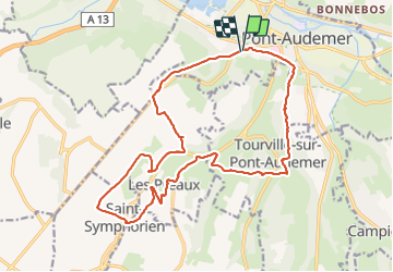
Tocht Stappen van 19,2 km beschikbaar op Normandië, Eure, Pont-Audemer. Deze tocht wordt voorgesteld door phiber76.
Beschrijving
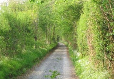
Randonnée en montagnes russes et variée: nombreux ruisseaux; belles maisons
Chasse possible dans les bois entre septembre et février
Si la randonnée est faite dans le sens anti-horaire, pique-niquer sur le site de la chapelle des Préaux
Plaatsbepaling
Land:
France
Regio :
Normandië
Departement/Provincie :
Eure
Gemeente :
Pont-Audemer
Locatie:
Unknown
Vertrek:(Dec)
Vertrek:(UTM)
318736 ; 5469190 (31U) N.
Opmerkingen
Wandeltochten in de omgeving
![Tocht Stappen Tourville-sur-Pont-Audemer - Chemin de la Guinguette - Photo](https://media.geolcdn.com/t/375/260/ext.jpg?maxdim=2&url=https%3A%2F%2Fstatic1.geolcdn.com%2Fsiteimages%2Fupload%2Ffiles%2F1553511878bg_sport_marche.png)
![Stappen Stappen](https://static1.geolcdn.com/sitytour/trail-icons/101.png)
Chemin de la Guinguette
Stappen
Moeilijk
(1)
Tourville-sur-Pont-Audemer,
Normandië,
Eure,
France
![](/images/other/stat-length.png)
9,5 km | 13,2 km-effort
2h 47min
![](https://static1.geolcdn.com/siteimages/upload/files/16400158638029165_repeat_loop_refresh_sync_direction_icon.png)
Ja
![Tocht Stappen Le Perrey - chemin des Têtards - Photo](https://media.geolcdn.com/t/375/260/ext.jpg?maxdim=2&url=https%3A%2F%2Fservices.sitytrail.com%2FGeolivesWS%2FDownloadMedia.ashx%3FTrailID%3D487376%26Media%3Dfix__20151030163357.jpg)
![Stappen Stappen](https://static1.geolcdn.com/sitytour/trail-icons/101.png)
chemin des Têtards
Stappen
Medium
Le Perrey,
Normandië,
Eure,
France
![](/images/other/stat-length.png)
7,8 km | 9,2 km-effort
2h 21min
![](https://static1.geolcdn.com/siteimages/upload/files/16400158638029165_repeat_loop_refresh_sync_direction_icon.png)
Ja
![Tocht Mountainbike Saint-Symphorien - Chemin du Vent d'Ouest - Saint-Symphorien - Photo](https://media.geolcdn.com/t/375/260/ext.jpg?maxdim=2&url=https%3A%2F%2Fservices.sitytrail.com%2FGeolivesWS%2FDownloadMedia.ashx%3FTrailID%3D317529%26Media%3D16770_3.jpg)
![Mountainbike Mountainbike](https://static1.geolcdn.com/sitytour/trail-icons/202.png)
Chemin du Vent d'Ouest - Saint-Symphorien
Mountainbike
Gemakkelijk
Saint-Symphorien,
Normandië,
Eure,
France
![](/images/other/stat-length.png)
8,7 km | 9,8 km-effort
1h 0min
![](https://static1.geolcdn.com/siteimages/upload/files/16400158638029165_repeat_loop_refresh_sync_direction_icon.png)
Ja
![Tocht Stappen Saint-Symphorien - Chemin du Vent d'Ouest - Saint-Symphorien - Photo](https://media.geolcdn.com/t/375/260/ext.jpg?maxdim=2&url=https%3A%2F%2Fservices.sitytrail.com%2FGeolivesWS%2FDownloadMedia.ashx%3FTrailID%3D317527%26Media%3D16770_3.jpg)
![Stappen Stappen](https://static1.geolcdn.com/sitytour/trail-icons/101.png)
Chemin du Vent d'Ouest - Saint-Symphorien
Stappen
Medium
Saint-Symphorien,
Normandië,
Eure,
France
![](/images/other/stat-length.png)
8,7 km | 9,8 km-effort
2h 19min
![](https://static1.geolcdn.com/siteimages/upload/files/16400158638029165_repeat_loop_refresh_sync_direction_icon.png)
Ja
![Tocht Stappen Campigny - 20230913-Campigny claude - Photo](https://media.geolcdn.com/t/375/260/e87c75f9-63b8-424b-9f87-c0f02837dbcf.jpg&format=jpg&maxdim=2)
![Stappen Stappen](https://static1.geolcdn.com/sitytour/trail-icons/101.png)
20230913-Campigny claude
Stappen
Medium
Campigny,
Normandië,
Eure,
France
![](/images/other/stat-length.png)
7,9 km | 10,2 km-effort
2h 26min
![](https://static1.geolcdn.com/siteimages/upload/files/16400158638029165_repeat_loop_refresh_sync_direction_icon.png)
Ja
![Tocht Stappen Toutainville - les étangs avec Nolan - Photo](https://media.geolcdn.com/t/375/260/8276ca23-05b1-48e4-99dc-88604e09070f.jpg&format=jpg&maxdim=2)
![Stappen Stappen](https://static1.geolcdn.com/sitytour/trail-icons/101.png)
les étangs avec Nolan
Stappen
Heel gemakkelijk
Toutainville,
Normandië,
Eure,
France
![](/images/other/stat-length.png)
3,3 km | 3,5 km-effort
58min
![](https://static1.geolcdn.com/siteimages/upload/files/16400158638029165_repeat_loop_refresh_sync_direction_icon.png)
Ja
![Tocht Stappen Le Perrey - Fourmetot - Photo](https://media.geolcdn.com/t/375/260/837619bd-2e70-4d88-b2cc-66c03ed786d4.jpg&format=jpg&maxdim=2)
![Stappen Stappen](https://static1.geolcdn.com/sitytour/trail-icons/101.png)
![Tocht Stappen Toutainville - les Etangs de Toutainville - Photo](https://media.geolcdn.com/t/375/260/ext.jpg?maxdim=2&url=https%3A%2F%2Fstatic1.geolcdn.com%2Fsiteimages%2Fupload%2Ffiles%2F1553511878bg_sport_marche.png)
![Stappen Stappen](https://static1.geolcdn.com/sitytour/trail-icons/101.png)
les Etangs de Toutainville
Stappen
Gemakkelijk
Toutainville,
Normandië,
Eure,
France
![](/images/other/stat-length.png)
4,7 km | 5 km-effort
1h 7min
![](https://static1.geolcdn.com/siteimages/upload/files/16400158638029165_repeat_loop_refresh_sync_direction_icon.png)
Ja
![Tocht Stappen Campigny - CAMPIGNY - Photo](https://media.geolcdn.com/t/375/260/ext.jpg?maxdim=2&url=https%3A%2F%2Fstatic1.geolcdn.com%2Fsiteimages%2Fupload%2Ffiles%2F1553511878bg_sport_marche.png)
![Stappen Stappen](https://static1.geolcdn.com/sitytour/trail-icons/101.png)