Tocht Mountainbike La Ciotat - 2021-10-27_20h19m21_tour-la-ciotat - Photo

2021-10-27_20h19m21_tour-la-ciotat

 HG74250
HG74250

Gebruiker

© OpenStreetMap contributors
Lengte
Lengte
31 km
Max. hoogte
Max. hoogte
450 m
Positief hoogteverschil
947 m
Km-Effort
Km-Effort  
43 km
Min. hoogte
Min. hoogte
2 m
Negatief hoogteverschil
941 m
Boucle
Boucle
Ja
Datum van aanmaak :
2021-10-27 18:19:21.717
Laatste wijziging :
2021-10-27 18:38:46.726

(0 Bericht)

Mountainbike
Mountainbike
2h59
Moeilijkheid : Zeer moeilijk

Scan deze QR-code om de tocht te openen in de SityTrail-applicatie

Gratisgps-wandelapplicatie

Logo SityTrail SityTrail

IGN / Geografische instituten

SityTrail uit de App Store downloaden SityTrail uit Google Play downloaden

Logo SityTrail SityTrail World

De wereld gaat voor u open

SityTrail uit de App Store downloaden SityTrail uit Google Play downloaden SityTrail op Huawei AppGallery downloaden

Over ons

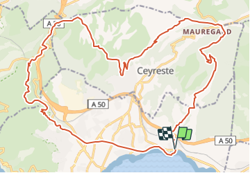
Tocht Mountainbike van 31 km beschikbaar op Provence-Alpes-Côte d'Azur, Bouches-du-Rhône, La Ciotat. Deze tocht wordt voorgesteld door HG74250.

Beschrijving

Petit tour Ciotaden...............................

Hoogteprofiel

Plaatsbepaling

Land:
France
Regio :
Provence-Alpes-Côte d'Azur
Departement/Provincie :
Bouches-du-Rhône
Gemeente :
La Ciotat
Locatie:
Unknown
Vertrek:(UTM)
715262 ; 4785318 (31T) N.

Wandeltochten in de omgeving

Tocht Stappen Ceyreste - Autour du Montounier 2eme version - Photo
Stappen
GUIDE
affinetataille

Stappen

Medium
(1)
Ceyreste, Provence-Alpes-Côte d'Azur, Bouches-du-Rhône, France
15,7 km | 24 km-effort
6h 0min
Ja
Tocht Stappen La Ciotat - Rando Ciotat - Photo
Stappen
GUIDE
affinetataille

Stappen

Moeilijk
(1)
La Ciotat, Provence-Alpes-Côte d'Azur, Bouches-du-Rhône, France
12,1 km | 19,9 km-effort
7h 30min
Ja
Tocht Stappen La Ciotat - la ciotat - Photo
Stappen
Berrangerannick

Stappen

Heel gemakkelijk
(1)
La Ciotat, Provence-Alpes-Côte d'Azur, Bouches-du-Rhône, France
6,2 km | 9,3 km-effort
3h 21min
Ja
Tocht Stappen Saint-Cyr-sur-Mer - St Cyr  - Bandol - Photo
Stappen
kephas

Stappen

Medium
(1)
Saint-Cyr-sur-Mer, Provence-Alpes-Côte d'Azur, Var, France
16,1 km | 21 km-effort
4h 53min
Neen
Tocht Noords wandelen La Cadière-d'Azur - 20220329_La Cadière d'Azur - Photo
Noords wandelen
Marcsaintcyr

Noords wandelen

Heel gemakkelijk
(1)
La Cadière-d'Azur, Provence-Alpes-Côte d'Azur, Var, France
6,8 km | 8,6 km-effort
1h 30min
Ja
Tocht Noords wandelen La Cadière-d'Azur - 20220329_La Cadière d'Azur - Photo
Noords wandelen
Marcsaintcyr

Noords wandelen

Heel gemakkelijk
(1)
La Cadière-d'Azur, Provence-Alpes-Côte d'Azur, Var, France
6,8 km | 8,6 km-effort
1h 30min
Ja
Tocht Te voet Saint-Cyr-sur-Mer - Sentier du littoral (Saint-Cyr-sur-Mer) - Photo
Te voet
GUIDE+

Te voet

Gemakkelijk
Saint-Cyr-sur-Mer, Provence-Alpes-Côte d'Azur, Var, France
4,9 km | 6,5 km-effort
1h 27min
Neen
Tocht Stappen La Ciotat - Balade La Ciotat  - Photo
Stappen
BADEY

Stappen

Moeilijk
(1)
La Ciotat, Provence-Alpes-Côte d'Azur, Bouches-du-Rhône, France
8,8 km | 14 km-effort
3h 7min
Ja
Tocht Stappen Saint-Cyr-sur-Mer - le sentier littoral de la Madrague et la colline de sable - Photo
Stappen
GUIDE
amiral13

Stappen

Gemakkelijk
(1)
Saint-Cyr-sur-Mer, Provence-Alpes-Côte d'Azur, Var, France
13 km | 18,7 km-effort
5h 20min
Ja


Sluiten
Mijn abonnementen