![](/images/other/stat-length.png)
![Tocht Stappen Tegueste - Cruz del Carmen - Bajamar PR-TF12 - Photo](https://media.geolcdn.com/t/1900/400/869fb28d-8541-4ec9-95a5-44120c6d68b4.jpg&format=pjpeg&maxdim=2)
Cruz del Carmen - Bajamar PR-TF12
Wouter Brunia
Gebruiker
![Lengte](/images/other/stat-length.png)
![Max. hoogte](https://static1.geolcdn.com/siteimages/upload/files/1508320355ic_sort_altitude_max_24dp.png)
![Positief hoogteverschil](https://static1.geolcdn.com/siteimages/upload/files/1508320355ic_sort_den_pos_24dp.png)
![Km-Effort](/images/other/stat-length.png)
![Min. hoogte](https://static1.geolcdn.com/siteimages/upload/files/1508320355ic_sort_altitude_min_24dp.png)
![Negatief hoogteverschil](https://static1.geolcdn.com/siteimages/upload/files/1508320355ic_sort_den_neg_24dp.png)
![Boucle](https://static1.geolcdn.com/siteimages/upload/files/16400158638029165_repeat_loop_refresh_sync_direction_icon.png)
![Stappen](https://static1.geolcdn.com/sitytour/trail-icons/101.png)
4h44
Moeilijkheid : Moeilijk
![Scan deze QR-code om de tocht te openen in de SityTrail-applicatie](https://capi.geolives.com/qq0zvz2zws4bq2lad0pu/sitytour/trails/2950848/qr.png?size=200)
Gratisgps-wandelapplicatie
Over ons
Tocht Stappen van 9,3 km beschikbaar op Canarische Eilanden, Santa Cruz de Tenerife, Tegueste. Deze tocht wordt voorgesteld door Wouter Brunia.
Beschrijving
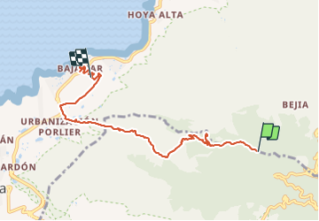
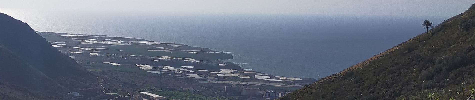
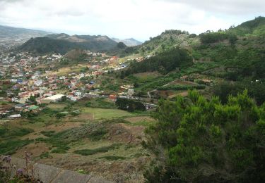
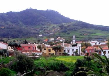
part of the PR-TF12 we took the bus to Cruz del Carmen and walked down to Bajamar, the first part is easy and you walk in the forest.
The route recording starts later, where the signage is good! Follow the route on the same side of the road when you reach the metal gate and road after around one KM. Ignore the yellow white crosses (here you shouldn't go) and follow the double markings yellow white. At the information center at the start you can get a map, but it's not very precise. You can buy sandwiches and some fruits. Make sure to bring at least 500ml water per person!
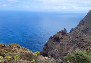
The second part is going down all the time, quite steel on mountain side trail. There is no cover from the sun and it can get hot! This part is tough, but absolutely stunning! Don't forget a good hat, sunglasses and suncream.
It is possible to take side routes to Pedro Alvarez (PR-TF12.2) or Tegueste (PR-TF12.1) . Both have bus connections with Titsa (titsa.com)
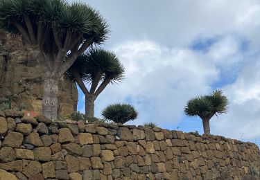
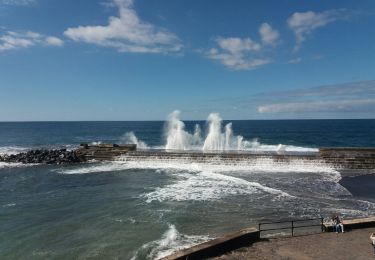
Final stage you walk in Bajamar through agricultural area and wind down towards the bus stop. Here you also find shops and restaurants. Bring swim suit for a dip in the natural pool (few minutes walking).
Plaatsbepaling
Opmerkingen
Wandeltochten in de omgeving
![Tocht Stappen San Cristóbal de La Laguna - Massif de l'Anaga El Batan Chinamada - Photo](https://media.geolcdn.com/t/375/260/bf287400-cf63-4351-bbc9-dbe9aba0fa64.jpg&format=jpg&maxdim=2)
![Stappen Stappen](https://static1.geolcdn.com/sitytour/trail-icons/101.png)
Stappen
![](/images/other/stat-length.png)
![](https://static1.geolcdn.com/siteimages/upload/files/16400158638029165_repeat_loop_refresh_sync_direction_icon.png)
![Tocht Te voet Tegueste - El bosque de los enigmas - Photo](https://media.geolcdn.com/t/375/260/1a03fed7-fb28-4a0e-9d0f-13adda6bed3b.jpeg&format=jpg&maxdim=2)
![Te voet Te voet](https://static1.geolcdn.com/sitytour/trail-icons/100.png)
Te voet
![](/images/other/stat-length.png)
![](https://static1.geolcdn.com/siteimages/upload/files/16400158638029165_repeat_loop_refresh_sync_direction_icon.png)
![Tocht Te voet Tegueste - SL-TG 03 Las Canteras-Las Toscas - Photo](https://media.geolcdn.com/t/375/260/9b02a4e1-6549-4943-9eb8-9ef13f2363ff.jpeg&format=jpg&maxdim=2)
![Te voet Te voet](https://static1.geolcdn.com/sitytour/trail-icons/100.png)
Te voet
![](/images/other/stat-length.png)
![](https://static1.geolcdn.com/siteimages/upload/files/16400158638029165_repeat_loop_refresh_sync_direction_icon.png)
![Tocht Te voet San Cristóbal de La Laguna - ES-SL-TG 01 Tegueste-Bajamar - Photo](https://media.geolcdn.com/t/375/260/65f44273-f2cc-400e-98ab-6e6e24660cd8.jpeg&format=jpg&maxdim=2)
![Te voet Te voet](https://static1.geolcdn.com/sitytour/trail-icons/100.png)
Te voet
![](/images/other/stat-length.png)
![](https://static1.geolcdn.com/siteimages/upload/files/16400158638029165_repeat_loop_refresh_sync_direction_icon.png)
![Tocht Stappen San Cristóbal de La Laguna - Punta del Hidalgo - Chinamada - Photo](https://media.geolcdn.com/t/375/260/2c9fb02f-c984-4854-86fb-fc5721d63a53.jpg&format=jpg&maxdim=2)
![Stappen Stappen](https://static1.geolcdn.com/sitytour/trail-icons/101.png)
Stappen
![](/images/other/stat-length.png)
![](https://static1.geolcdn.com/siteimages/upload/files/16400158638029165_repeat_loop_refresh_sync_direction_icon.png)
![Tocht Stappen San Cristóbal de La Laguna - Las Carbonaras Chimada AR - Photo](https://media.geolcdn.com/t/375/260/b1c626c3-3510-4ce3-890e-282b82838da6.jpg&format=jpg&maxdim=2)
![Stappen Stappen](https://static1.geolcdn.com/sitytour/trail-icons/101.png)
Stappen
![](/images/other/stat-length.png)
![](https://static1.geolcdn.com/siteimages/upload/files/16400158638029165_repeat_loop_refresh_sync_direction_icon.png)
![Te voet Te voet](https://static1.geolcdn.com/sitytour/trail-icons/100.png)
Te voet
![](/images/other/stat-length.png)
![](https://static1.geolcdn.com/siteimages/upload/files/16400158638029165_repeat_loop_refresh_sync_direction_icon.png)
![Tocht Stappen San Cristóbal de La Laguna - Cruz del Carmen al Mar Bajamar - Photo](https://media.geolcdn.com/t/375/260/ext.jpg?maxdim=2&url=https%3A%2F%2Fservices.sitytrail.com%2FGeolivesWS%2FDownloadMedia.ashx%3FTrailID%3D908007%26Media%3Dfix__20180218155348.jpg)
![Stappen Stappen](https://static1.geolcdn.com/sitytour/trail-icons/101.png)
Stappen
![](/images/other/stat-length.png)
![](https://static1.geolcdn.com/siteimages/upload/files/16400158638029165_repeat_loop_refresh_sync_direction_icon.png)
![Tocht Stappen San Cristóbal de La Laguna - forêt primaire de l'Anaga - Photo](https://media.geolcdn.com/t/375/260/ext.jpg?maxdim=2&url=https%3A%2F%2Fservices.sitytrail.com%2FGeolivesWS%2FDownloadMedia.ashx%3FTrailID%3D422872%26Media%3D20150511145711.jpg)
![Stappen Stappen](https://static1.geolcdn.com/sitytour/trail-icons/101.png)
Stappen
![](/images/other/stat-length.png)
![](https://static1.geolcdn.com/siteimages/upload/files/16400158638029165_repeat_loop_refresh_sync_direction_icon.png)