![](/images/other/stat-length.png)
![Tocht Stappen Colmars - Tête et col de l'Encombrette-22-09-21 - Photo](https://media.geolcdn.com/t/1900/400/107b9fb8-8673-4a8d-a591-7893dff94f56.jpg&format=pjpeg&maxdim=2)
Tête et col de l'Encombrette-22-09-21
Christiancordin
Gebruiker
![Lengte](/images/other/stat-length.png)
Lengte
22 km
![Max. hoogte](https://static1.geolcdn.com/siteimages/upload/files/1508320355ic_sort_altitude_max_24dp.png)
Max. hoogte
2546 m
![Positief hoogteverschil](https://static1.geolcdn.com/siteimages/upload/files/1508320355ic_sort_den_pos_24dp.png)
Positief hoogteverschil
1399 m
![Km-Effort](/images/other/stat-length.png)
Km-Effort
41 km
![Min. hoogte](https://static1.geolcdn.com/siteimages/upload/files/1508320355ic_sort_altitude_min_24dp.png)
Min. hoogte
1450 m
![Negatief hoogteverschil](https://static1.geolcdn.com/siteimages/upload/files/1508320355ic_sort_den_neg_24dp.png)
Negatief hoogteverschil
1399 m
![Boucle](https://static1.geolcdn.com/siteimages/upload/files/16400158638029165_repeat_loop_refresh_sync_direction_icon.png)
Boucle
Ja
Datum van aanmaak :
2021-09-22 07:21:01.907
Laatste wijziging :
2021-09-24 12:13:35.581
![Stappen](https://static1.geolcdn.com/sitytour/trail-icons/101.png)
6h08
Moeilijkheid : Moeilijk
![Scan deze QR-code om de tocht te openen in de SityTrail-applicatie](https://capi.geolives.com/qq0zvz2zws4bq2lad0pu/sitytour/trails/2946397/qr.png?size=200)
Gratisgps-wandelapplicatie
Over ons
Tocht Stappen van 22 km beschikbaar op Provence-Alpes-Côte d'Azur, Alpes-de-Haute-Provence, Colmars. Deze tocht wordt voorgesteld door Christiancordin.
Beschrijving
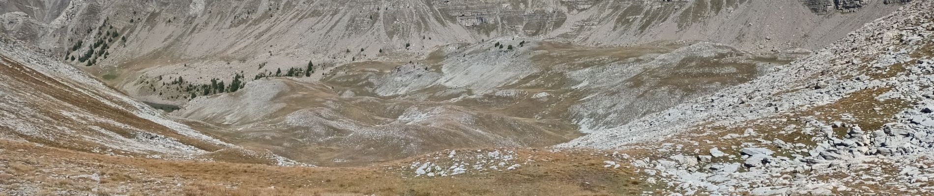
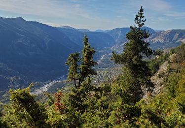
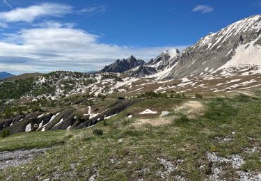
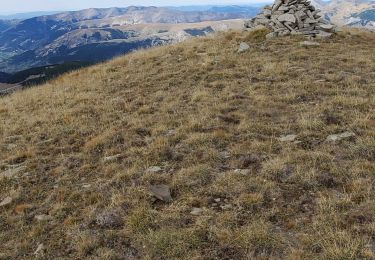
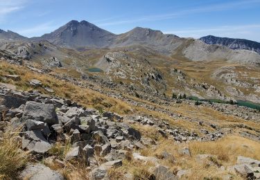
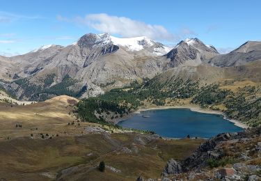
Pk rte de Clignon Haut-Clignon Haut-les Costes-GR de pays du haut Verdon-pas de l'Echelle-cabane de l'Encombrette-lacs de l'Encombrette-tête de l'Encombrette-col de l'Encombrette.
Plaatsbepaling
Land:
France
Regio :
Provence-Alpes-Côte d'Azur
Departement/Provincie :
Alpes-de-Haute-Provence
Gemeente :
Colmars
Locatie:
Unknown
Vertrek:(Dec)
Vertrek:(UTM)
311491 ; 4896583 (32T) N.
Opmerkingen
Wandeltochten in de omgeving
![Tocht Stappen Colmars - Les lacs Lignin - Photo](https://media.geolcdn.com/t/375/260/fbca6767-bae4-46df-a02f-745bbf118b44.jpg&format=jpg&maxdim=2)
![Stappen Stappen](https://static1.geolcdn.com/sitytour/trail-icons/101.png)
Les lacs Lignin
Stappen
Moeilijk
Colmars,
Provence-Alpes-Côte d'Azur,
Alpes-de-Haute-Provence,
France
![](/images/other/stat-length.png)
18,8 km | 29 km-effort
5h 33min
![](https://static1.geolcdn.com/siteimages/upload/files/16400158638029165_repeat_loop_refresh_sync_direction_icon.png)
Ja
![Tocht Stappen Colmars - Colmars petit coyer 993m 14kms - Photo](https://media.geolcdn.com/t/375/260/34cedc48-3841-4962-bcc9-facfdb32c9cc.jpg&format=jpg&maxdim=2)
![Stappen Stappen](https://static1.geolcdn.com/sitytour/trail-icons/101.png)
Colmars petit coyer 993m 14kms
Stappen
Medium
Colmars,
Provence-Alpes-Côte d'Azur,
Alpes-de-Haute-Provence,
France
![](/images/other/stat-length.png)
13,3 km | 27 km-effort
6h 38min
![](https://static1.geolcdn.com/siteimages/upload/files/16400158638029165_repeat_loop_refresh_sync_direction_icon.png)
Ja
![Tocht Stappen Colmars - Colmars autapie 19.5k ms 1200m - Photo](https://media.geolcdn.com/t/375/260/9d112094-8159-4db6-8f08-1f5a21c98a9f.jpg&format=jpg&maxdim=2)
![Stappen Stappen](https://static1.geolcdn.com/sitytour/trail-icons/101.png)
Colmars autapie 19.5k ms 1200m
Stappen
Medium
Colmars,
Provence-Alpes-Côte d'Azur,
Alpes-de-Haute-Provence,
France
![](/images/other/stat-length.png)
18,8 km | 35 km-effort
7h 43min
![](https://static1.geolcdn.com/siteimages/upload/files/16400158638029165_repeat_loop_refresh_sync_direction_icon.png)
Ja
![Stappen Stappen](https://static1.geolcdn.com/sitytour/trail-icons/101.png)
Pk Ratery - Col des Champs
Stappen
Medium
Colmars,
Provence-Alpes-Côte d'Azur,
Alpes-de-Haute-Provence,
France
![](/images/other/stat-length.png)
6,2 km | 10,3 km-effort
2h 20min
![](https://static1.geolcdn.com/siteimages/upload/files/16400158638029165_repeat_loop_refresh_sync_direction_icon.png)
Neen
![Tocht Stappen Saint-Martin-d'Entraunes - Tête de l’Encombrette - Photo](https://media.geolcdn.com/t/375/260/236d9d6e-bf01-4b0d-a6b0-e10b7b571a51.jpg&format=jpg&maxdim=2)
![Stappen Stappen](https://static1.geolcdn.com/sitytour/trail-icons/101.png)
Tête de l’Encombrette
Stappen
Zeer moeilijk
Saint-Martin-d'Entraunes,
Provence-Alpes-Côte d'Azur,
Alpes-Maritimes,
France
![](/images/other/stat-length.png)
9,8 km | 19,7 km-effort
4h 55min
![](https://static1.geolcdn.com/siteimages/upload/files/16400158638029165_repeat_loop_refresh_sync_direction_icon.png)
Ja
![Tocht Stappen Colmars - petit coyer - Photo](https://media.geolcdn.com/t/375/260/68c25c46-6e07-4761-95ca-0791cf3cb843.jpg&format=jpg&maxdim=2)
![Stappen Stappen](https://static1.geolcdn.com/sitytour/trail-icons/101.png)
petit coyer
Stappen
Medium
Colmars,
Provence-Alpes-Côte d'Azur,
Alpes-de-Haute-Provence,
France
![](/images/other/stat-length.png)
15,1 km | 29 km-effort
8h 5min
![](https://static1.geolcdn.com/siteimages/upload/files/16400158638029165_repeat_loop_refresh_sync_direction_icon.png)
Neen
![Tocht Stappen Colmars - clignon encombrette - Photo](https://media.geolcdn.com/t/375/260/be8c3d38-73f7-4208-88b1-25cf6491a9c9.jpg&format=jpg&maxdim=2)
![Stappen Stappen](https://static1.geolcdn.com/sitytour/trail-icons/101.png)
clignon encombrette
Stappen
Medium
Colmars,
Provence-Alpes-Côte d'Azur,
Alpes-de-Haute-Provence,
France
![](/images/other/stat-length.png)
16,7 km | 31 km-effort
8h 44min
![](https://static1.geolcdn.com/siteimages/upload/files/16400158638029165_repeat_loop_refresh_sync_direction_icon.png)
Ja
![Tocht Stappen Colmars - Col de l](https://media.geolcdn.com/t/375/260/09a91b7d-2e2d-4897-a96c-c33d12bc529d.jpg&format=jpg&maxdim=2)
![Stappen Stappen](https://static1.geolcdn.com/sitytour/trail-icons/101.png)
Col de l"Encombrette AR Clignon Haut
Stappen
Zeer moeilijk
Colmars,
Provence-Alpes-Côte d'Azur,
Alpes-de-Haute-Provence,
France
![](/images/other/stat-length.png)
17,1 km | 31 km-effort
7h 8min
![](https://static1.geolcdn.com/siteimages/upload/files/16400158638029165_repeat_loop_refresh_sync_direction_icon.png)
Ja
![Tocht Stappen Colmars - Colmars les Alpes - Pk de la Serre - ZigZag dans les vasques de la Lance - Photo](https://media.geolcdn.com/t/375/260/2e7bad42-214a-41b1-87c2-fc5514798ec7.jpg&format=jpg&maxdim=2)
![Stappen Stappen](https://static1.geolcdn.com/sitytour/trail-icons/101.png)
Colmars les Alpes - Pk de la Serre - ZigZag dans les vasques de la Lance
Stappen
Moeilijk
Colmars,
Provence-Alpes-Côte d'Azur,
Alpes-de-Haute-Provence,
France
![](/images/other/stat-length.png)
8,6 km | 14,1 km-effort
2h 28min
![](https://static1.geolcdn.com/siteimages/upload/files/16400158638029165_repeat_loop_refresh_sync_direction_icon.png)
Ja