![](/images/other/stat-length.png)
![Tocht Stappen Ranrupt - Ranrupt autour du Climont - Photo](https://media.geolcdn.com/t/1900/400/630b66c4-91a1-4319-94c5-9d8ea2f45d50.jpg&format=pjpeg&maxdim=2)
Ranrupt autour du Climont
LUTZMarc
Gebruiker
![Lengte](/images/other/stat-length.png)
Lengte
17,1 km
![Max. hoogte](https://static1.geolcdn.com/siteimages/upload/files/1508320355ic_sort_altitude_max_24dp.png)
Max. hoogte
712 m
![Positief hoogteverschil](https://static1.geolcdn.com/siteimages/upload/files/1508320355ic_sort_den_pos_24dp.png)
Positief hoogteverschil
562 m
![Km-Effort](/images/other/stat-length.png)
Km-Effort
25 km
![Min. hoogte](https://static1.geolcdn.com/siteimages/upload/files/1508320355ic_sort_altitude_min_24dp.png)
Min. hoogte
511 m
![Negatief hoogteverschil](https://static1.geolcdn.com/siteimages/upload/files/1508320355ic_sort_den_neg_24dp.png)
Negatief hoogteverschil
561 m
![Boucle](https://static1.geolcdn.com/siteimages/upload/files/16400158638029165_repeat_loop_refresh_sync_direction_icon.png)
Boucle
Ja
Datum van aanmaak :
2021-09-09 07:12:34.729
Laatste wijziging :
2021-09-09 18:48:04.309
![Stappen](https://static1.geolcdn.com/sitytour/trail-icons/101.png)
4h30
Moeilijkheid : Medium
![Scan deze QR-code om de tocht te openen in de SityTrail-applicatie](https://capi.geolives.com/qq0zvz2zws4bq2lad0pu/sitytour/trails/2930794/qr.png?size=200)
Gratisgps-wandelapplicatie
Over ons
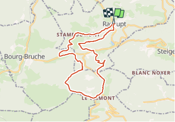
Tocht Stappen van 17,1 km beschikbaar op Grand Est, Bas-Rhin, Ranrupt. Deze tocht wordt voorgesteld door LUTZMarc.
Beschrijving
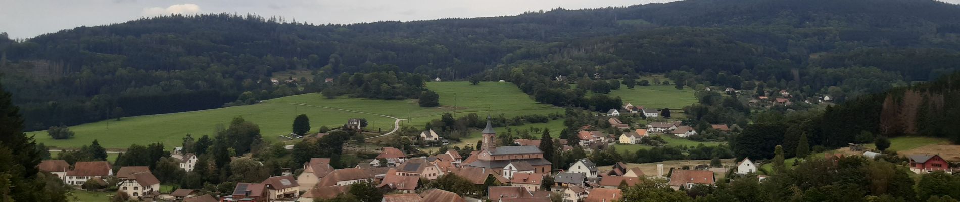
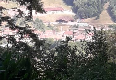
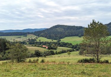
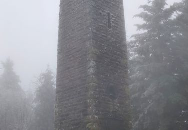
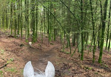
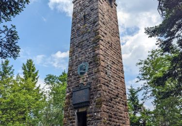
Départ au parking de l'église de Ranrupt. Parcours forestier qui débouche souvent sur de l'alpage avec de superbe point de vue.
Possibilité de resto à l'Auberge des cimes au climont. (km 10) .Pensez à réserver.
Plaatsbepaling
Land:
France
Regio :
Grand Est
Departement/Provincie :
Bas-Rhin
Gemeente :
Ranrupt
Locatie:
Unknown
Vertrek:(Dec)
Vertrek:(UTM)
366502 ; 5359421 (32U) N.
Opmerkingen
Wandeltochten in de omgeving
![Tocht Stappen Steige - Steige blanc - Photo](https://media.geolcdn.com/t/375/260/3138d5a8-8f43-46fd-9a0c-b8aa1ff2972d.jpg&format=jpg&maxdim=2)
![Stappen Stappen](https://static1.geolcdn.com/sitytour/trail-icons/101.png)
Steige blanc
Stappen
Medium
(1)
Steige,
Grand Est,
Bas-Rhin,
France
![](/images/other/stat-length.png)
7,8 km | 12,6 km-effort
2h 7min
![](https://static1.geolcdn.com/siteimages/upload/files/16400158638029165_repeat_loop_refresh_sync_direction_icon.png)
Ja
![Tocht Paardrijden Bourg-Bruche - 2023-09-16 Picnic CVA Climont Bourg Bruche - Photo](https://media.geolcdn.com/t/375/260/e3b3477a-361e-4f3c-9903-89043f8145ea.jpg&format=jpg&maxdim=2)
![Paardrijden Paardrijden](https://static1.geolcdn.com/sitytour/trail-icons/301.png)
2023-09-16 Picnic CVA Climont Bourg Bruche
Paardrijden
Medium
Bourg-Bruche,
Grand Est,
Bas-Rhin,
France
![](/images/other/stat-length.png)
27 km | 39 km-effort
5h 11min
![](https://static1.geolcdn.com/siteimages/upload/files/16400158638029165_repeat_loop_refresh_sync_direction_icon.png)
Ja
![Tocht Stappen Ranrupt - 2018-12-30 Marche Climont Voyemont - Photo](https://media.geolcdn.com/t/375/260/55e3f2c1-2c0e-4070-b418-3c553de20538.jpg&format=jpg&maxdim=2)
![Stappen Stappen](https://static1.geolcdn.com/sitytour/trail-icons/101.png)
2018-12-30 Marche Climont Voyemont
Stappen
Heel gemakkelijk
Ranrupt,
Grand Est,
Bas-Rhin,
France
![](/images/other/stat-length.png)
22 km | 33 km-effort
7h 21min
![](https://static1.geolcdn.com/siteimages/upload/files/16400158638029165_repeat_loop_refresh_sync_direction_icon.png)
Ja
![Tocht Paardrijden Belmont - Acpl 2ème jour Belmont Bellefosse - Photo](https://media.geolcdn.com/t/375/260/68f69c23-4011-4ca8-9039-fce627777a58.jpg&format=jpg&maxdim=2)
![Paardrijden Paardrijden](https://static1.geolcdn.com/sitytour/trail-icons/301.png)
Acpl 2ème jour Belmont Bellefosse
Paardrijden
Medium
Belmont,
Grand Est,
Bas-Rhin,
France
![](/images/other/stat-length.png)
17,3 km | 25 km-effort
3h 20min
![](https://static1.geolcdn.com/siteimages/upload/files/16400158638029165_repeat_loop_refresh_sync_direction_icon.png)
Ja
![Tocht Paardrijden Belmont - Circuit VC Serva - Le Climont - Photo](https://media.geolcdn.com/t/375/260/a1198139-b874-4847-adb3-efd42fb36195.jpg&format=jpg&maxdim=2)
![Paardrijden Paardrijden](https://static1.geolcdn.com/sitytour/trail-icons/301.png)
Circuit VC Serva - Le Climont
Paardrijden
Medium
Belmont,
Grand Est,
Bas-Rhin,
France
![](/images/other/stat-length.png)
23 km | 33 km-effort
4h 20min
![](https://static1.geolcdn.com/siteimages/upload/files/16400158638029165_repeat_loop_refresh_sync_direction_icon.png)
Neen
![Tocht Paardrijden Belmont - Circuit VC Le Hohwald - Serva - Photo](https://media.geolcdn.com/t/375/260/1588be67-92f1-44c9-a365-dcd95e3feb13.jpg&format=jpg&maxdim=2)
![Paardrijden Paardrijden](https://static1.geolcdn.com/sitytour/trail-icons/301.png)
Circuit VC Le Hohwald - Serva
Paardrijden
Medium
Belmont,
Grand Est,
Bas-Rhin,
France
![](/images/other/stat-length.png)
16,2 km | 22 km-effort
2h 50min
![](https://static1.geolcdn.com/siteimages/upload/files/16400158638029165_repeat_loop_refresh_sync_direction_icon.png)
Neen
![Tocht Stappen Bellefosse - Col de la Charbonnière - château de la Roche - Bellefosse - Belmont - Photo](https://media.geolcdn.com/t/375/260/24310c6f-c7f0-4534-8ba0-5207981b0c8c.jpg&format=jpg&maxdim=2)
![Stappen Stappen](https://static1.geolcdn.com/sitytour/trail-icons/101.png)
Col de la Charbonnière - château de la Roche - Bellefosse - Belmont
Stappen
Zeer moeilijk
Bellefosse,
Grand Est,
Bas-Rhin,
France
![](/images/other/stat-length.png)
15,7 km | 24 km-effort
5h 27min
![](https://static1.geolcdn.com/siteimages/upload/files/16400158638029165_repeat_loop_refresh_sync_direction_icon.png)
Ja
![Tocht Stappen Ranrupt - 2023-06-04 Marche Col de Steige Tour du Climont - Photo](https://media.geolcdn.com/t/375/260/935b7e44-7265-42c7-b6c2-a8897e52a122.jpg&format=jpg&maxdim=2)
![Stappen Stappen](https://static1.geolcdn.com/sitytour/trail-icons/101.png)
2023-06-04 Marche Col de Steige Tour du Climont
Stappen
Gemakkelijk
Ranrupt,
Grand Est,
Bas-Rhin,
France
![](/images/other/stat-length.png)
14,5 km | 24 km-effort
5h 28min
![](https://static1.geolcdn.com/siteimages/upload/files/16400158638029165_repeat_loop_refresh_sync_direction_icon.png)
Ja
![Tocht Sneeuwschoenen Belmont - cascade de la serva - Photo](https://media.geolcdn.com/t/375/260/9e54cbbc-1369-400d-91a3-b8884cb0f35c.jpg&format=jpg&maxdim=2)
![Sneeuwschoenen Sneeuwschoenen](https://static1.geolcdn.com/sitytour/trail-icons/504.png)
cascade de la serva
Sneeuwschoenen
Medium
Belmont,
Grand Est,
Bas-Rhin,
France
![](/images/other/stat-length.png)
7,1 km | 10,8 km-effort
3h 41min
![](https://static1.geolcdn.com/siteimages/upload/files/16400158638029165_repeat_loop_refresh_sync_direction_icon.png)
Ja