![](/images/other/stat-length.png)
![Tocht Stappen Δημοτική Ενότητα Κυθήρων - Vers le phare de Moudari - Photo](https://media.geolcdn.com/t/1900/400/ext.pjpeg?maxdim=2&url=https%3A%2F%2Fmedia.geolcdn.com%2Ff%2F150bba5e-af3a-4a6a-8804-bd93215813a2.jpg)
Vers le phare de Moudari
LBarel
Gebruiker
![Lengte](/images/other/stat-length.png)
![Max. hoogte](https://static1.geolcdn.com/siteimages/upload/files/1508320355ic_sort_altitude_max_24dp.png)
![Positief hoogteverschil](https://static1.geolcdn.com/siteimages/upload/files/1508320355ic_sort_den_pos_24dp.png)
![Km-Effort](/images/other/stat-length.png)
![Min. hoogte](https://static1.geolcdn.com/siteimages/upload/files/1508320355ic_sort_altitude_min_24dp.png)
![Negatief hoogteverschil](https://static1.geolcdn.com/siteimages/upload/files/1508320355ic_sort_den_neg_24dp.png)
![Boucle](https://static1.geolcdn.com/siteimages/upload/files/16400158638029165_repeat_loop_refresh_sync_direction_icon.png)
![Stappen](https://static1.geolcdn.com/sitytour/trail-icons/101.png)
2h10
Moeilijkheid : Medium
![Scan deze QR-code om de tocht te openen in de SityTrail-applicatie](https://capi.geolives.com/qq0zvz2zws4bq2lad0pu/sitytour/trails/2926868/qr.png?size=200)
Gratisgps-wandelapplicatie
Over ons
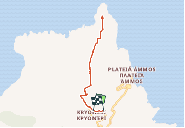
Tocht Stappen van 7,7 km beschikbaar op Attica, Περιφερειακή Ενότητα Νήσων, Δημοτική Ενότητα Κυθήρων. Deze tocht wordt voorgesteld door LBarel.
Beschrijving
Un aller-retour de Kryoneri vers le phare de Moudari au nord de Cythère. Il existe de vrais chemins de randonnées que nous avons croisés régulièrement, mais ici il s'agit de routes non asphaltées larges et très praticables qui permettent de se concentrer sur le paysage plutôt que sur ses pieds. Très agréable balade.
Plaatsbepaling
Opmerkingen
Wandeltochten in de omgeving
![Tocht Te voet Δημοτική Ενότητα Κυθήρων - M41 Mylopotamos Trail (long loop) - Photo](https://media.geolcdn.com/t/375/260/ext.jpg?maxdim=2&url=https%3A%2F%2Fmedia.geolcdn.com%2Ff%2F2f73411d-c491-4617-b6e1-53059594d683.jpeg)
![Te voet Te voet](https://static1.geolcdn.com/sitytour/trail-icons/100.png)
Te voet
![](/images/other/stat-length.png)
![](https://static1.geolcdn.com/siteimages/upload/files/16400158638029165_repeat_loop_refresh_sync_direction_icon.png)