![](/images/other/stat-length.png)
![Tocht Stappen Roquefort-les-Pins - Roquefort Boucle Loup Castellas Camp Tracier - Photo](https://media.geolcdn.com/t/1900/400/ext.pjpeg?maxdim=2&url=https%3A%2F%2Fstatic1.geolcdn.com%2Fsiteimages%2Fupload%2Ffiles%2F1553511878bg_sport_marche.png)
Roquefort Boucle Loup Castellas Camp Tracier
pjjrevrard
Gebruiker
![Lengte](/images/other/stat-length.png)
Lengte
10,2 km
![Max. hoogte](https://static1.geolcdn.com/siteimages/upload/files/1508320355ic_sort_altitude_max_24dp.png)
Max. hoogte
257 m
![Positief hoogteverschil](https://static1.geolcdn.com/siteimages/upload/files/1508320355ic_sort_den_pos_24dp.png)
Positief hoogteverschil
310 m
![Km-Effort](/images/other/stat-length.png)
Km-Effort
14,3 km
![Min. hoogte](https://static1.geolcdn.com/siteimages/upload/files/1508320355ic_sort_altitude_min_24dp.png)
Min. hoogte
40 m
![Negatief hoogteverschil](https://static1.geolcdn.com/siteimages/upload/files/1508320355ic_sort_den_neg_24dp.png)
Negatief hoogteverschil
309 m
![Boucle](https://static1.geolcdn.com/siteimages/upload/files/16400158638029165_repeat_loop_refresh_sync_direction_icon.png)
Boucle
Ja
Datum van aanmaak :
2021-09-02 20:30:48.487
Laatste wijziging :
2021-09-03 13:32:44.272
![Stappen](https://static1.geolcdn.com/sitytour/trail-icons/101.png)
2h45
Moeilijkheid : Moeilijk
![Scan deze QR-code om de tocht te openen in de SityTrail-applicatie](https://capi.geolives.com/qq0zvz2zws4bq2lad0pu/sitytour/trails/2922460/qr.png?size=200)
Gratisgps-wandelapplicatie
Over ons
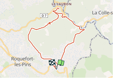
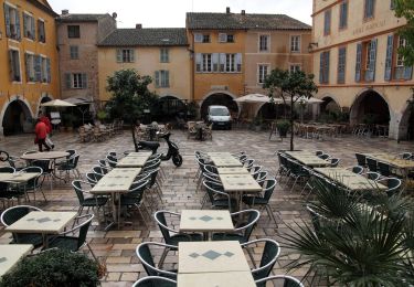
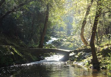
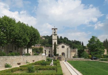
Tocht Stappen van 10,2 km beschikbaar op Provence-Alpes-Côte d'Azur, Alpes-Maritimes, Roquefort-les-Pins. Deze tocht wordt voorgesteld door pjjrevrard.
Beschrijving
Beau parcours boisé et dénivellé. Dans la descente vers le Loup et la D6, il n'est pas conseillé de prendre le sentier "raccourci" en Z; la fin de la descente est assez dangereuse.
Plaatsbepaling
Land:
France
Regio :
Provence-Alpes-Côte d'Azur
Departement/Provincie :
Alpes-Maritimes
Gemeente :
Roquefort-les-Pins
Locatie:
Unknown
Vertrek:(Dec)
Vertrek:(UTM)
344215 ; 4836248 (32T) N.
Opmerkingen
Wandeltochten in de omgeving
![Tocht Te voet Roquefort-les-Pins - Le Rucher - Photo](https://media.geolcdn.com/t/375/260/8984dec4-46ee-4507-9355-103df05628e2.jpeg&format=jpg&maxdim=2)
![Te voet Te voet](https://static1.geolcdn.com/sitytour/trail-icons/100.png)
Le Rucher
Te voet
Gemakkelijk
Roquefort-les-Pins,
Provence-Alpes-Côte d'Azur,
Alpes-Maritimes,
France
![](/images/other/stat-length.png)
3,7 km | 4,8 km-effort
1h 5min
![](https://static1.geolcdn.com/siteimages/upload/files/16400158638029165_repeat_loop_refresh_sync_direction_icon.png)
Neen
![Tocht Te voet Biot - Sentier de la Vallée de la Brague - Photo](https://media.geolcdn.com/t/375/260/69d5693d-b435-48ea-9803-59cdfb2bd33a.jpeg&format=jpg&maxdim=2)
![Te voet Te voet](https://static1.geolcdn.com/sitytour/trail-icons/100.png)
Sentier de la Vallée de la Brague
Te voet
Gemakkelijk
Biot,
Provence-Alpes-Côte d'Azur,
Alpes-Maritimes,
France
![](/images/other/stat-length.png)
10 km | 12,5 km-effort
2h 50min
![](https://static1.geolcdn.com/siteimages/upload/files/16400158638029165_repeat_loop_refresh_sync_direction_icon.png)
Neen
![Tocht Te voet Valbonne - Circuit des Macarons - Photo](https://media.geolcdn.com/t/375/260/fccba7f8-a613-4c51-ac4f-1073b0b24a76.jpeg&format=jpg&maxdim=2)
![Te voet Te voet](https://static1.geolcdn.com/sitytour/trail-icons/100.png)
Circuit des Macarons
Te voet
Gemakkelijk
Valbonne,
Provence-Alpes-Côte d'Azur,
Alpes-Maritimes,
France
![](/images/other/stat-length.png)
6,3 km | 8,6 km-effort
1h 57min
![](https://static1.geolcdn.com/siteimages/upload/files/16400158638029165_repeat_loop_refresh_sync_direction_icon.png)
Ja
![Tocht Te voet Valbonne - Circuit des Bouillides - Photo](https://media.geolcdn.com/t/375/260/83f1adf9-9b71-481b-afb6-9317825a7553.jpeg&format=jpg&maxdim=2)
![Te voet Te voet](https://static1.geolcdn.com/sitytour/trail-icons/100.png)
Circuit des Bouillides
Te voet
Gemakkelijk
Valbonne,
Provence-Alpes-Côte d'Azur,
Alpes-Maritimes,
France
![](/images/other/stat-length.png)
10,6 km | 13,9 km-effort
3h 8min
![](https://static1.geolcdn.com/siteimages/upload/files/16400158638029165_repeat_loop_refresh_sync_direction_icon.png)
Ja
![Tocht Te voet Valbonne - Circuit du Bruguet - Photo](https://media.geolcdn.com/t/375/260/68fef880-5161-4eed-ba0f-265464725084.jpeg&format=jpg&maxdim=2)
![Te voet Te voet](https://static1.geolcdn.com/sitytour/trail-icons/100.png)
Circuit du Bruguet
Te voet
Gemakkelijk
Valbonne,
Provence-Alpes-Côte d'Azur,
Alpes-Maritimes,
France
![](/images/other/stat-length.png)
7,2 km | 9,4 km-effort
2h 7min
![](https://static1.geolcdn.com/siteimages/upload/files/16400158638029165_repeat_loop_refresh_sync_direction_icon.png)
Ja
![Tocht Te voet Biot - Circuit de Saint-Philippe - Photo](https://media.geolcdn.com/t/375/260/4ea5c2a5-8352-4835-88c7-4e46e7f4f872.jpeg&format=jpg&maxdim=2)
![Te voet Te voet](https://static1.geolcdn.com/sitytour/trail-icons/100.png)
Circuit de Saint-Philippe
Te voet
Gemakkelijk
Biot,
Provence-Alpes-Côte d'Azur,
Alpes-Maritimes,
France
![](/images/other/stat-length.png)
3,3 km | 4,7 km-effort
1h 4min
![](https://static1.geolcdn.com/siteimages/upload/files/16400158638029165_repeat_loop_refresh_sync_direction_icon.png)
Neen
![Tocht Te voet Biot - Circuit des Pierres à Four - Photo](https://media.geolcdn.com/t/375/260/4ea5c2a5-8352-4835-88c7-4e46e7f4f872.jpeg&format=jpg&maxdim=2)
![Te voet Te voet](https://static1.geolcdn.com/sitytour/trail-icons/100.png)
Circuit des Pierres à Four
Te voet
Gemakkelijk
Biot,
Provence-Alpes-Côte d'Azur,
Alpes-Maritimes,
France
![](/images/other/stat-length.png)
10,3 km | 13 km-effort
2h 57min
![](https://static1.geolcdn.com/siteimages/upload/files/16400158638029165_repeat_loop_refresh_sync_direction_icon.png)
Ja
![Tocht Te voet Roquefort-les-Pins - Circuit de Darbousson - Photo](https://media.geolcdn.com/t/375/260/44967fea-2064-4a68-9f35-3101615fda90.jpeg&format=jpg&maxdim=2)
![Te voet Te voet](https://static1.geolcdn.com/sitytour/trail-icons/100.png)
Circuit de Darbousson
Te voet
Gemakkelijk
Roquefort-les-Pins,
Provence-Alpes-Côte d'Azur,
Alpes-Maritimes,
France
![](/images/other/stat-length.png)
9,2 km | 11,8 km-effort
2h 40min
![](https://static1.geolcdn.com/siteimages/upload/files/16400158638029165_repeat_loop_refresh_sync_direction_icon.png)
Ja
![Tocht Te voet Valbonne - Circuit de Font Martine - Photo](https://media.geolcdn.com/t/375/260/380073f4-15ba-47bd-8024-3f9a492a47de.jpeg&format=jpg&maxdim=2)
![Te voet Te voet](https://static1.geolcdn.com/sitytour/trail-icons/100.png)
Circuit de Font Martine
Te voet
Gemakkelijk
Valbonne,
Provence-Alpes-Côte d'Azur,
Alpes-Maritimes,
France
![](/images/other/stat-length.png)
7,9 km | 10 km-effort
2h 16min
![](https://static1.geolcdn.com/siteimages/upload/files/16400158638029165_repeat_loop_refresh_sync_direction_icon.png)
Ja