![](/images/other/stat-length.png)
![Tocht Stappen Saint-Paul-de-Vence - St-Paul Vence St Paul par le Melvan - Photo](https://media.geolcdn.com/t/1900/400/ext.pjpeg?maxdim=2&url=https%3A%2F%2Fstatic1.geolcdn.com%2Fsiteimages%2Fupload%2Ffiles%2F1553511878bg_sport_marche.png)
St-Paul Vence St Paul par le Melvan
pjjrevrard
Gebruiker
![Lengte](/images/other/stat-length.png)
Lengte
10,1 km
![Max. hoogte](https://static1.geolcdn.com/siteimages/upload/files/1508320355ic_sort_altitude_max_24dp.png)
Max. hoogte
341 m
![Positief hoogteverschil](https://static1.geolcdn.com/siteimages/upload/files/1508320355ic_sort_den_pos_24dp.png)
Positief hoogteverschil
339 m
![Km-Effort](/images/other/stat-length.png)
Km-Effort
14,6 km
![Min. hoogte](https://static1.geolcdn.com/siteimages/upload/files/1508320355ic_sort_altitude_min_24dp.png)
Min. hoogte
124 m
![Negatief hoogteverschil](https://static1.geolcdn.com/siteimages/upload/files/1508320355ic_sort_den_neg_24dp.png)
Negatief hoogteverschil
338 m
![Boucle](https://static1.geolcdn.com/siteimages/upload/files/16400158638029165_repeat_loop_refresh_sync_direction_icon.png)
Boucle
Ja
Datum van aanmaak :
2021-09-01 15:44:12.32
Laatste wijziging :
2021-09-01 15:46:48.254
![Stappen](https://static1.geolcdn.com/sitytour/trail-icons/101.png)
3h19
Moeilijkheid : Moeilijk
![Scan deze QR-code om de tocht te openen in de SityTrail-applicatie](https://capi.geolives.com/qq0zvz2zws4bq2lad0pu/sitytour/trails/2920892/qr.png?size=200)
Gratisgps-wandelapplicatie
Over ons
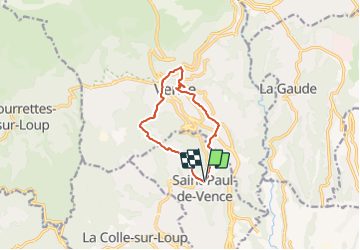
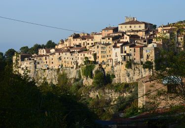
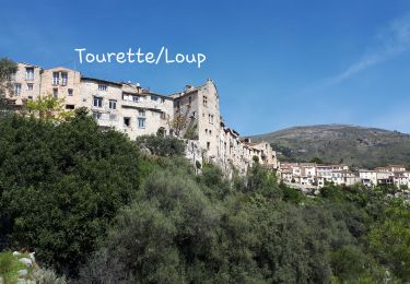
Tocht Stappen van 10,1 km beschikbaar op Provence-Alpes-Côte d'Azur, Alpes-Maritimes, Saint-Paul-de-Vence. Deze tocht wordt voorgesteld door pjjrevrard.
Beschrijving
St-Paul à Vence par le vallon aval du Melvan, la Chapelle Ste-Elisabeth, le conservatoire de musique de Vence. Retour depuis le centre historique par la Chapelle du Rosaire et le vallon amont du Melvan
Plaatsbepaling
Land:
France
Regio :
Provence-Alpes-Côte d'Azur
Departement/Provincie :
Alpes-Maritimes
Gemeente :
Saint-Paul-de-Vence
Locatie:
Unknown
Vertrek:(Dec)
Vertrek:(UTM)
348669 ; 4840233 (32T) N.
Opmerkingen
Wandeltochten in de omgeving
![Tocht Stappen Tourrettes-sur-Loup - Le Puy de Naouri 1024 m, depuis Tourrettes-sur-Loup - Photo](https://media.geolcdn.com/t/375/260/ext.jpg?maxdim=2&url=https%3A%2F%2Fservices.sitytrail.com%2FGeolivesWS%2FDownloadMedia.ashx%3FTrailID%3D214858%26Media%3D15396_1.jpg)
![Stappen Stappen](https://static1.geolcdn.com/sitytour/trail-icons/101.png)
Le Puy de Naouri 1024 m, depuis Tourrettes-sur-Loup
Stappen
Gemakkelijk
(1)
Tourrettes-sur-Loup,
Provence-Alpes-Côte d'Azur,
Alpes-Maritimes,
France
![](/images/other/stat-length.png)
13,1 km | 22 km-effort
4h 30min
![](https://static1.geolcdn.com/siteimages/upload/files/16400158638029165_repeat_loop_refresh_sync_direction_icon.png)
Ja
![Tocht Te voet Vence - Circuit du Malvan - Photo](https://media.geolcdn.com/t/375/260/a11b075b-d314-4d7d-9ea3-2c9f013025ba.jpeg&format=jpg&maxdim=2)
![Te voet Te voet](https://static1.geolcdn.com/sitytour/trail-icons/100.png)
Circuit du Malvan
Te voet
Gemakkelijk
Vence,
Provence-Alpes-Côte d'Azur,
Alpes-Maritimes,
France
![](/images/other/stat-length.png)
8,3 km | 12,4 km-effort
2h 49min
![](https://static1.geolcdn.com/siteimages/upload/files/16400158638029165_repeat_loop_refresh_sync_direction_icon.png)
Ja
![Tocht Te voet Tourrettes-sur-Loup - Puy de Naouri - Photo](https://media.geolcdn.com/t/375/260/a11b075b-d314-4d7d-9ea3-2c9f013025ba.jpeg&format=jpg&maxdim=2)
![Te voet Te voet](https://static1.geolcdn.com/sitytour/trail-icons/100.png)
Puy de Naouri
Te voet
Medium
Tourrettes-sur-Loup,
Provence-Alpes-Côte d'Azur,
Alpes-Maritimes,
France
![](/images/other/stat-length.png)
13 km | 22 km-effort
4h 57min
![](https://static1.geolcdn.com/siteimages/upload/files/16400158638029165_repeat_loop_refresh_sync_direction_icon.png)
Ja
![Tocht Mountainbike Roquefort-les-Pins - VTT Roquefort Fontmerle - Photo](https://media.geolcdn.com/t/375/260/ext.jpg?maxdim=2&url=https%3A%2F%2Fstatic1.geolcdn.com%2Fsiteimages%2Fupload%2Ffiles%2F1524743154velo.jpg)
![Mountainbike Mountainbike](https://static1.geolcdn.com/sitytour/trail-icons/202.png)
VTT Roquefort Fontmerle
Mountainbike
Medium
(3)
Roquefort-les-Pins,
Provence-Alpes-Côte d'Azur,
Alpes-Maritimes,
France
![](/images/other/stat-length.png)
33 km | 41 km-effort
3h 32min
![](https://static1.geolcdn.com/siteimages/upload/files/16400158638029165_repeat_loop_refresh_sync_direction_icon.png)
Ja
![Tocht Stappen Villeneuve-Loubet - Dome des Aspres, RLP Geologie - Photo](https://media.geolcdn.com/t/375/260/76d5ece3-3b69-438f-8d4d-cc971b3d3501.jpg&format=jpg&maxdim=2)
![Stappen Stappen](https://static1.geolcdn.com/sitytour/trail-icons/101.png)
Dome des Aspres, RLP Geologie
Stappen
Gemakkelijk
Villeneuve-Loubet,
Provence-Alpes-Côte d'Azur,
Alpes-Maritimes,
France
![](/images/other/stat-length.png)
3,4 km | 4,6 km-effort
1h 3min
![](https://static1.geolcdn.com/siteimages/upload/files/16400158638029165_repeat_loop_refresh_sync_direction_icon.png)
Neen
![Tocht Stappen La Gaude - La Gaude - Bord de Cagnes - Photo](https://media.geolcdn.com/t/375/260/09cd4e62-6c8c-4128-8210-e963af9700c2.jpg&format=jpg&maxdim=2)
![Stappen Stappen](https://static1.geolcdn.com/sitytour/trail-icons/101.png)
La Gaude - Bord de Cagnes
Stappen
Zeer moeilijk
La Gaude,
Provence-Alpes-Côte d'Azur,
Alpes-Maritimes,
France
![](/images/other/stat-length.png)
7,7 km | 11,4 km-effort
3h 19min
![](https://static1.geolcdn.com/siteimages/upload/files/16400158638029165_repeat_loop_refresh_sync_direction_icon.png)
Ja
![Stappen Stappen](https://static1.geolcdn.com/sitytour/trail-icons/101.png)
Tourettes sur Loup - Puy Naouri - Chapelle St Raphaël
Stappen
Medium
Tourrettes-sur-Loup,
Provence-Alpes-Côte d'Azur,
Alpes-Maritimes,
France
![](/images/other/stat-length.png)
13,7 km | 23 km-effort
3h 57min
![](https://static1.geolcdn.com/siteimages/upload/files/16400158638029165_repeat_loop_refresh_sync_direction_icon.png)
Ja
![Tocht Stappen La Colle-sur-Loup - La colle sur Loup/Tourette - Photo](https://media.geolcdn.com/t/375/260/00c8ccc8-9088-4b38-bbff-b2623efd1fd7.jpg&format=jpg&maxdim=2)
![Stappen Stappen](https://static1.geolcdn.com/sitytour/trail-icons/101.png)
La colle sur Loup/Tourette
Stappen
Gemakkelijk
La Colle-sur-Loup,
Provence-Alpes-Côte d'Azur,
Alpes-Maritimes,
France
![](/images/other/stat-length.png)
15,3 km | 23 km-effort
4h 38min
![](https://static1.geolcdn.com/siteimages/upload/files/16400158638029165_repeat_loop_refresh_sync_direction_icon.png)
Ja
![Tocht Stappen Tourrettes-sur-Loup - Puy de Naouri - Photo](https://media.geolcdn.com/t/375/260/2c7796bd-9797-45f1-9868-6f05f50dfe9c.jpg&format=jpg&maxdim=2)
![Stappen Stappen](https://static1.geolcdn.com/sitytour/trail-icons/101.png)
Puy de Naouri
Stappen
Medium
Tourrettes-sur-Loup,
Provence-Alpes-Côte d'Azur,
Alpes-Maritimes,
France
![](/images/other/stat-length.png)
13,6 km | 23 km-effort
6h 0min
![](https://static1.geolcdn.com/siteimages/upload/files/16400158638029165_repeat_loop_refresh_sync_direction_icon.png)
Ja