![](/images/other/stat-length.png)
![Tocht Stappen Besse-et-Saint-Anastaise - Besse_Couze_Pavin_2 - Photo](https://media.geolcdn.com/t/1900/400/1e6bc359-a943-4daf-9589-4661c8bf3763.jpg&format=pjpeg&maxdim=2)
Besse_Couze_Pavin_2
jagarnier
Gebruiker GUIDE
![Lengte](/images/other/stat-length.png)
![Max. hoogte](https://static1.geolcdn.com/siteimages/upload/files/1508320355ic_sort_altitude_max_24dp.png)
![Positief hoogteverschil](https://static1.geolcdn.com/siteimages/upload/files/1508320355ic_sort_den_pos_24dp.png)
![Km-Effort](/images/other/stat-length.png)
![Min. hoogte](https://static1.geolcdn.com/siteimages/upload/files/1508320355ic_sort_altitude_min_24dp.png)
![Negatief hoogteverschil](https://static1.geolcdn.com/siteimages/upload/files/1508320355ic_sort_den_neg_24dp.png)
![Boucle](https://static1.geolcdn.com/siteimages/upload/files/16400158638029165_repeat_loop_refresh_sync_direction_icon.png)
![Stappen](https://static1.geolcdn.com/sitytour/trail-icons/101.png)
5h15
Moeilijkheid : Medium
![Scan deze QR-code om de tocht te openen in de SityTrail-applicatie](https://capi.geolives.com/qq0zvz2zws4bq2lad0pu/sitytour/trails/2918174/qr.png?size=200)
Gratisgps-wandelapplicatie
Over ons
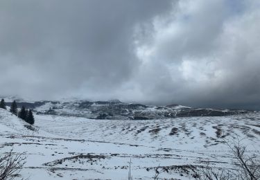
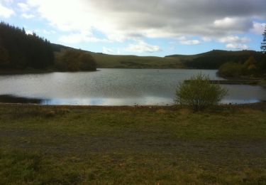
Tocht Stappen van 17,6 km beschikbaar op Auvergne-Rhône-Alpes, Puy-de-Dôme, Besse-et-Saint-Anastaise. Deze tocht wordt voorgesteld door jagarnier.
Beschrijving
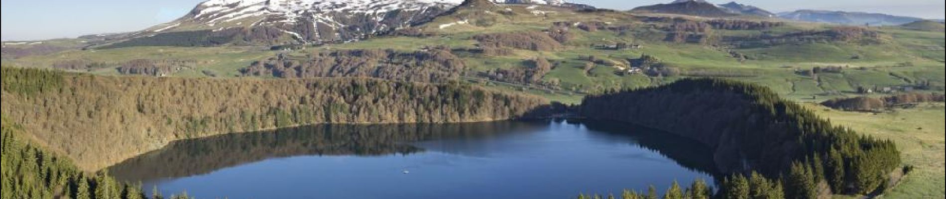
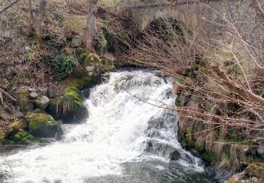
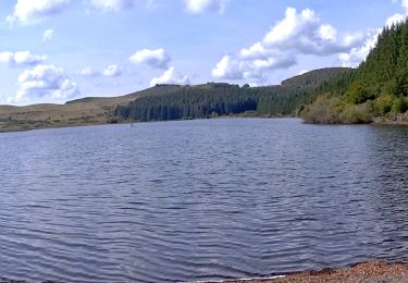
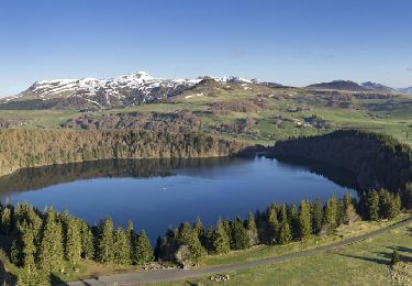
La cité médiévale de Besse-en-Chandesse, les rivières, lacs, forêts et volcans font le charme de ce beau circuit. Le chemin suit la Couze Pavin avant de grimper sur les crêtes et de contourner le Puy de Montchal. Au retour vous aurez un très beau point de vue sur le lac Pavin.
Plaatsbepaling
Opmerkingen
Wandeltochten in de omgeving
![Tocht Stappen Besse-et-Saint-Anastaise - Cascades de Chiloza - Photo](https://media.geolcdn.com/t/375/260/7c04b7ff-fd0b-4381-ace8-4f2ed0ec465b.jpg&format=jpg&maxdim=2)
![Stappen Stappen](https://static1.geolcdn.com/sitytour/trail-icons/101.png)
Stappen
![](/images/other/stat-length.png)
![](https://static1.geolcdn.com/siteimages/upload/files/16400158638029165_repeat_loop_refresh_sync_direction_icon.png)
![Stappen Stappen](https://static1.geolcdn.com/sitytour/trail-icons/101.png)
Stappen
![](/images/other/stat-length.png)
![](https://static1.geolcdn.com/siteimages/upload/files/16400158638029165_repeat_loop_refresh_sync_direction_icon.png)
![Tocht Stappen Besse-et-Saint-Anastaise - Besse_Couze_Pavin_1 - Photo](https://media.geolcdn.com/t/375/260/103ff33f-1fd8-4c46-a178-5c713f741cc1.jpg&format=jpg&maxdim=2)
![Stappen Stappen](https://static1.geolcdn.com/sitytour/trail-icons/101.png)
Stappen
![](/images/other/stat-length.png)
![](https://static1.geolcdn.com/siteimages/upload/files/16400158638029165_repeat_loop_refresh_sync_direction_icon.png)
![Tocht Stappen Saint-Victor-la-Rivière - St_Victor_Foret_Courbanges - Photo](https://media.geolcdn.com/t/375/260/9fef1c83-9b6e-46fe-9ede-9513f0c587d7.jpg&format=jpg&maxdim=2)
![Stappen Stappen](https://static1.geolcdn.com/sitytour/trail-icons/101.png)
Stappen
![](/images/other/stat-length.png)
![](https://static1.geolcdn.com/siteimages/upload/files/16400158638029165_repeat_loop_refresh_sync_direction_icon.png)
![Tocht Stappen Besse-et-Saint-Anastaise - Lac_Pavin_Montchal - Photo](https://media.geolcdn.com/t/375/260/0a17a073-6f46-4dad-9995-801fb5c96c4d.jpg&format=jpg&maxdim=2)
![Stappen Stappen](https://static1.geolcdn.com/sitytour/trail-icons/101.png)
Stappen
![](/images/other/stat-length.png)
![](https://static1.geolcdn.com/siteimages/upload/files/16400158638029165_repeat_loop_refresh_sync_direction_icon.png)
![Tocht Stappen Besse-et-Saint-Anastaise - Les 3 lacs et la cascade - Photo](https://media.geolcdn.com/t/375/260/50f54827-36a7-4b68-99c1-d5774caacba8.jpg&format=jpg&maxdim=2)
![Stappen Stappen](https://static1.geolcdn.com/sitytour/trail-icons/101.png)
Stappen
![](/images/other/stat-length.png)
![](https://static1.geolcdn.com/siteimages/upload/files/16400158638029165_repeat_loop_refresh_sync_direction_icon.png)
![Tocht Mountainbike Besse-et-Saint-Anastaise - Espace VTT FFC du Sancy - Circuit n°30 - Tour des Lacs - Secteur Besse - Photo](https://media.geolcdn.com/t/375/260/ext.jpg?maxdim=2&url=https%3A%2F%2Fservices.sitytrail.com%2FGeolivesWS%2FDownloadMedia.ashx%3FTrailID%3D172888%26Media%3D14346_2.jpg)
![Mountainbike Mountainbike](https://static1.geolcdn.com/sitytour/trail-icons/202.png)
Mountainbike
![](/images/other/stat-length.png)
![](https://static1.geolcdn.com/siteimages/upload/files/16400158638029165_repeat_loop_refresh_sync_direction_icon.png)
![Tocht Stappen Besse-et-Saint-Anastaise - Les cascades de Chiloza - Photo](https://media.geolcdn.com/t/375/260/ext.jpg?maxdim=2&url=https%3A%2F%2Fservices.sitytrail.com%2FGeolivesWS%2FDownloadMedia.ashx%3FTrailID%3D149215%26Media%3D20120822161328.jpeg)
![Stappen Stappen](https://static1.geolcdn.com/sitytour/trail-icons/101.png)
Stappen
![](/images/other/stat-length.png)
![](https://static1.geolcdn.com/siteimages/upload/files/16400158638029165_repeat_loop_refresh_sync_direction_icon.png)
![Tocht Stappen Besse-et-Saint-Anastaise - Les trois lacs - Pavin - Montcineyre et Bourdouze - Photo](https://media.geolcdn.com/t/375/260/ext.jpg?maxdim=2&url=https%3A%2F%2Fservices.sitytrail.com%2FGeolivesWS%2FDownloadMedia.ashx%3FTrailID%3D107365%26Media%3D12262_2.jpg)
![Stappen Stappen](https://static1.geolcdn.com/sitytour/trail-icons/101.png)
Stappen
![](/images/other/stat-length.png)
![](https://static1.geolcdn.com/siteimages/upload/files/16400158638029165_repeat_loop_refresh_sync_direction_icon.png)