![](/images/other/stat-length.png)
![Tocht Stappen Vallehermoso - Canaries - La Gomera - Vallehermoso/Santa Clara - jour 8 - Photo](https://media.geolcdn.com/t/1900/400/ext.pjpeg?maxdim=2&url=https%3A%2F%2Fstatic1.geolcdn.com%2Fsiteimages%2Fupload%2Ffiles%2F1553511878bg_sport_marche.png)
Canaries - La Gomera - Vallehermoso/Santa Clara - jour 8
fhascoet
Gebruiker
![Lengte](/images/other/stat-length.png)
![Max. hoogte](https://static1.geolcdn.com/siteimages/upload/files/1508320355ic_sort_altitude_max_24dp.png)
![Positief hoogteverschil](https://static1.geolcdn.com/siteimages/upload/files/1508320355ic_sort_den_pos_24dp.png)
![Km-Effort](/images/other/stat-length.png)
![Min. hoogte](https://static1.geolcdn.com/siteimages/upload/files/1508320355ic_sort_altitude_min_24dp.png)
![Negatief hoogteverschil](https://static1.geolcdn.com/siteimages/upload/files/1508320355ic_sort_den_neg_24dp.png)
![Boucle](https://static1.geolcdn.com/siteimages/upload/files/16400158638029165_repeat_loop_refresh_sync_direction_icon.png)
![Stappen](https://static1.geolcdn.com/sitytour/trail-icons/101.png)
6h30
Moeilijkheid : Moeilijk
![Scan deze QR-code om de tocht te openen in de SityTrail-applicatie](https://capi.geolives.com/qq0zvz2zws4bq2lad0pu/sitytour/trails/2917646/qr.png?size=200)
Gratisgps-wandelapplicatie
Over ons
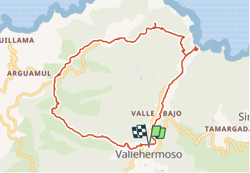
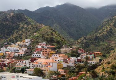
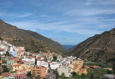
Tocht Stappen van 14,1 km beschikbaar op Canarische Eilanden, Santa Cruz de Tenerife, Vallehermoso. Deze tocht wordt voorgesteld door fhascoet.
Beschrijving
Montée en quittant le village vers le bel espace aménagé à l'ermitage de Santa Clara.
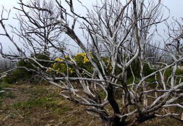
Randonnée facile sur la crète avec de beaux points de vue
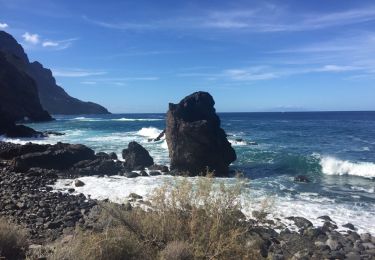
Puis descente très raide vers la plage où une superbe piscine d'eau de mer vous attend.
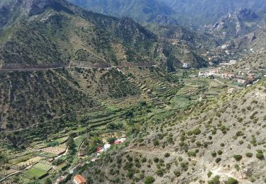
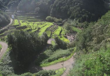
Retour vers Vallehermoso par un chemin qui longe le fond de la vallée, a travers les plantations.
Durée avec arret déjeuner compris
Plaatsbepaling
Opmerkingen
Wandeltochten in de omgeving
![Tocht Stappen Vallehermoso - gomera taso - Photo](https://media.geolcdn.com/t/375/260/ext.jpg?maxdim=2&url=https%3A%2F%2Fservices.sitytrail.com%2FGeolivesWS%2FDownloadMedia.ashx%3FTrailID%3D480545%26Media%3D20151008113700.jpg)
![Stappen Stappen](https://static1.geolcdn.com/sitytour/trail-icons/101.png)
Stappen
![](/images/other/stat-length.png)
![](https://static1.geolcdn.com/siteimages/upload/files/16400158638029165_repeat_loop_refresh_sync_direction_icon.png)
![Tocht Te voet Vallehermoso - Ruta 04 - Photo](https://media.geolcdn.com/t/375/260/877b4429-1a8a-4993-91f0-1f9ba1237b8e.jpeg&format=jpg&maxdim=2)
![Te voet Te voet](https://static1.geolcdn.com/sitytour/trail-icons/100.png)
Te voet
![](/images/other/stat-length.png)
![](https://static1.geolcdn.com/siteimages/upload/files/16400158638029165_repeat_loop_refresh_sync_direction_icon.png)
![Tocht Stappen Vallehermoso - La Gomera - Valhermoso Santa Clara (4) 8/5/2019 - Photo](https://media.geolcdn.com/t/375/260/30434ec8-9caa-4226-b188-f68ed5492556.jpg&format=jpg&maxdim=2)
![Stappen Stappen](https://static1.geolcdn.com/sitytour/trail-icons/101.png)
Stappen
![](/images/other/stat-length.png)
![](https://static1.geolcdn.com/siteimages/upload/files/16400158638029165_repeat_loop_refresh_sync_direction_icon.png)
![Tocht Stappen Vallehermoso - gomera taso - Photo](https://media.geolcdn.com/t/375/260/ext.jpg?maxdim=2&url=https%3A%2F%2Fservices.sitytrail.com%2FGeolivesWS%2FDownloadMedia.ashx%3FTrailID%3D1110143%26Media%3D20151008113700.jpg)
![Stappen Stappen](https://static1.geolcdn.com/sitytour/trail-icons/101.png)
Stappen
![](/images/other/stat-length.png)
![](https://static1.geolcdn.com/siteimages/upload/files/16400158638029165_repeat_loop_refresh_sync_direction_icon.png)
![Tocht Te voet Vallehermoso - Ruta 38 - Photo](https://media.geolcdn.com/t/375/260/a5114c43-9390-43db-ae2f-f55e2339105d.jpeg&format=jpg&maxdim=2)
![Te voet Te voet](https://static1.geolcdn.com/sitytour/trail-icons/100.png)
Te voet
![](/images/other/stat-length.png)
![](https://static1.geolcdn.com/siteimages/upload/files/16400158638029165_repeat_loop_refresh_sync_direction_icon.png)
![Tocht Te voet Hermigua - Reventón Oscuro - El Cedro - Photo](https://media.geolcdn.com/t/375/260/894e2729-5fef-471c-801f-1eaa4ed76d4c.jpeg&format=jpg&maxdim=2)
![Te voet Te voet](https://static1.geolcdn.com/sitytour/trail-icons/100.png)
Te voet
![](/images/other/stat-length.png)
![](https://static1.geolcdn.com/siteimages/upload/files/16400158638029165_repeat_loop_refresh_sync_direction_icon.png)
![Tocht Te voet Hermigua - Ruta 9: El Contadero - Chorro del Cedro - Photo](https://media.geolcdn.com/t/375/260/170a792b-f466-4df4-95eb-754e8c2f554c.jpeg&format=jpg&maxdim=2)
![Te voet Te voet](https://static1.geolcdn.com/sitytour/trail-icons/100.png)
Te voet
![](/images/other/stat-length.png)
![](https://static1.geolcdn.com/siteimages/upload/files/16400158638029165_repeat_loop_refresh_sync_direction_icon.png)
![Tocht Te voet Hermigua - Ruta 11: La Meseta de Hermigua - Chorro del Cedro - Photo](https://media.geolcdn.com/t/375/260/9ee5583b-8203-4e03-a5fc-f7ea80c15335.jpeg&format=jpg&maxdim=2)
![Te voet Te voet](https://static1.geolcdn.com/sitytour/trail-icons/100.png)
Te voet
![](/images/other/stat-length.png)
![](https://static1.geolcdn.com/siteimages/upload/files/16400158638029165_repeat_loop_refresh_sync_direction_icon.png)
![Tocht Te voet Valle Gran Rey - Cañada de Jorge - Photo](https://media.geolcdn.com/t/375/260/579162eb-caab-490a-aca6-b48da9d89d76.jpeg&format=jpg&maxdim=2)
![Te voet Te voet](https://static1.geolcdn.com/sitytour/trail-icons/100.png)
Te voet
![](/images/other/stat-length.png)
![](https://static1.geolcdn.com/siteimages/upload/files/16400158638029165_repeat_loop_refresh_sync_direction_icon.png)