Tocht Stappen Formiguères - formigueres station ski - camporeils 10km 890m - Photo

formigueres station ski - camporeils 10km 890m

 Erius
Erius

Gebruiker

© OpenStreetMap contributors
Lengte
Lengte
12,5 km
Max. hoogte
Max. hoogte
2418 m
Positief hoogteverschil
881 m
Km-Effort
Km-Effort  
24 km
Min. hoogte
Min. hoogte
1757 m
Negatief hoogteverschil
879 m
Boucle
Boucle
Ja
Datum van aanmaak :
2021-08-28 07:19:41.693
Laatste wijziging :
2021-08-28 17:19:20.553

(0 Bericht)

Stappen
Stappen
3h00
Moeilijkheid : Medium

Scan deze QR-code om de tocht te openen in de SityTrail-applicatie

Gratisgps-wandelapplicatie

Logo SityTrail SityTrail

IGN / Geografische instituten

SityTrail uit de App Store downloaden SityTrail uit Google Play downloaden

Logo SityTrail SityTrail World

De wereld gaat voor u open

SityTrail uit de App Store downloaden SityTrail uit Google Play downloaden SityTrail op Huawei AppGallery downloaden

Over ons

Tocht Stappen van 12,5 km beschikbaar op Occitanië, Pyrénées-Orientales, Formiguères. Deze tocht wordt voorgesteld door Erius.

Beschrijving

1 bout de piste au départ de la station par oratoire et Jacques. forêt. bout de piste forêt et crêtes enduites.  Belle vue sur les camporeils . descente 170m
et retour idem

Hoogteprofiel

Plaatsbepaling

Land:
France
Regio :
Occitanië
Departement/Provincie :
Pyrénées-Orientales
Gemeente :
Formiguères
Locatie:
Unknown
Vertrek:(UTM)
423755 ; 4719463 (31T) N.

Wandeltochten in de omgeving

Tocht Stappen Formiguères - Les Camporells par la Lladure  - Photo
Stappen
jcmartin

Stappen

Medium
(1)
Formiguères, Occitanië, Pyrénées-Orientales, France
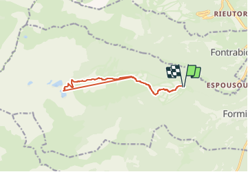
15,1 km | 24 km-effort
5h 7min
Ja
Tocht sport Formiguères - 20240728 Station Formiguères - Camporeils - Photo
sport
ThonyM

sport

Heel gemakkelijk
Formiguères, Occitanië, Pyrénées-Orientales, France
16 km | 27 km-effort
Onbekend
Ja
Tocht Stappen Puyvalador - Puyvalador tour du lac  - Photo
Stappen
GUIDE
antignacs

Stappen

Heel gemakkelijk
Puyvalador, Occitanië, Pyrénées-Orientales, France
12,1 km | 15,9 km-effort
3h 39min
Ja
Tocht Stappen Formiguères - 20210819 Porteille d’Orlu, étang du diable - Photo
Stappen
ThonyM

Stappen

Moeilijk
Formiguères, Occitanië, Pyrénées-Orientales, France
16,4 km | 29 km-effort
5h 3min
Ja
Tocht Stappen Formiguères - 20210710 pla del bosc - Foumigueres - Photo
Stappen
ThonyM

Stappen

Gemakkelijk
Formiguères, Occitanië, Pyrénées-Orientales, France
12,5 km | 18,3 km-effort
2h 47min
Ja
Tocht Sneeuwschoenen Les Angles - 2021-02-11 Sortie CAF - Les Angles - vers les Camporells - Photo
Sneeuwschoenen
eric.mignot

Sneeuwschoenen

Medium
Les Angles, Occitanië, Pyrénées-Orientales, France
16,8 km | 24 km-effort
7h 0min
Ja
Tocht Sneeuwschoenen Formiguères - Formigueres el collet  - Photo
Sneeuwschoenen
GUIDE
antignacs

Sneeuwschoenen

Heel gemakkelijk
Formiguères, Occitanië, Pyrénées-Orientales, France
6,4 km | 8,7 km-effort
2h 47min
Ja
Tocht Sneeuwschoenen Matemale - Tour lac mattemale neige  - Photo
Sneeuwschoenen
GUIDE
antignacs

Sneeuwschoenen

Heel gemakkelijk
Matemale, Occitanië, Pyrénées-Orientales, France
9,1 km | 10,4 km-effort
3h 5min
Ja
Tocht Stappen Les Angles - Boucle depuis lac de Balcere vers Estany de l'Esparver - Photo
Stappen
prous31

Stappen

Medium
Les Angles, Occitanië, Pyrénées-Orientales, France
13,4 km | 21 km-effort
4h 22min
Ja


Sluiten
Mijn abonnementen