Tocht Paardrijden Villandry - Location history from 2021-08-21 to 2021-08-21 - Photo

Location history from 2021-08-21 to 2021-08-21

 mattr91
mattr91

Gebruiker

© OpenStreetMap contributors
Lengte
Lengte
16,7 km
Max. hoogte
Max. hoogte
99 m
Positief hoogteverschil
147 m
Km-Effort
Km-Effort  
18,6 km
Min. hoogte
Min. hoogte
39 m
Negatief hoogteverschil
144 m
Boucle
Boucle
Ja
Datum van aanmaak :
2021-08-22 16:54:01.942
Laatste wijziging :
2021-08-23 07:23:30.548

(1 Bericht)

Paardrijden
Paardrijden
2h27
Moeilijkheid : Gemakkelijk
Huifkarwandeling
Huifkarwandeling
3h00
Moeilijkheid : Gemakkelijk

Scan deze QR-code om de tocht te openen in de SityTrail-applicatie

Gratisgps-wandelapplicatie

Logo SityTrail SityTrail

IGN / Geografische instituten

SityTrail uit de App Store downloaden SityTrail uit Google Play downloaden

Logo SityTrail SityTrail World

De wereld gaat voor u open

SityTrail uit de App Store downloaden SityTrail uit Google Play downloaden SityTrail op Huawei AppGallery downloaden

Over ons

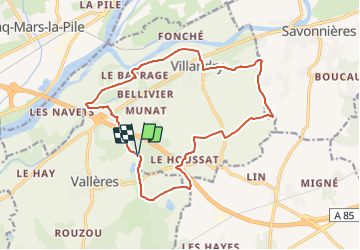
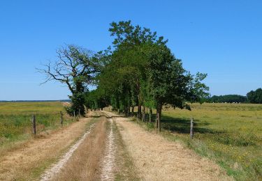
Tocht Paardrijden van 16,7 km beschikbaar op Centre-Val de Loire, Indre-et-Loire, Villandry. Deze tocht wordt voorgesteld door mattr91.

Hoogteprofiel

Plaatsbepaling

Land:
France
Regio :
Centre-Val de Loire
Departement/Provincie :
Indre-et-Loire
Gemeente :
Villandry
Locatie:
Unknown
Vertrek:(UTM)
310334 ; 5243566 (31T) N.

Opmerkingen

Gelieve in te loggen om een commentaar of een beoordeling achter te laten


Top. Pas mal de route mais super sympa


Wandeltochten in de omgeving

Tocht Stappen Villandry - Villandry - 2015 05 24 - Photo
Stappen
GUIDE
Orcal37

Stappen

Gemakkelijk
(1)
Villandry, Centre-Val de Loire, Indre-et-Loire, France
4,9 km | 5,7 km-effort
1h 15min
Ja
Tocht Stappen Vallères - Vallères le Hay - Zig zag Lignières-de-Touraine - 27.2km 300m 6h00 (50mn) - 2024 06 05 - Photo
Stappen
GUIDE
Orcal37

Stappen

Medium
Vallères, Centre-Val de Loire, Indre-et-Loire, France
27 km | 31 km-effort
6h 0min
Ja
Tocht Stappen Savonnières - Savonnières - Zig zag Villandry - 20.7km 260m 4h25 (40mn) - 2024 06 02 - Photo
Stappen
GUIDE
Orcal37

Stappen

Gemakkelijk
Savonnières, Centre-Val de Loire, Indre-et-Loire, France
21 km | 24 km-effort
4h 25min
Ja
Tocht Stappen Vallères - Vallères - Zig zag Manoir de Fontenay - 26.2km 350m 6h00 (35mn) - 2024 05 31 - Photo
Stappen
GUIDE
Orcal37

Stappen

Gemakkelijk
Vallères, Centre-Val de Loire, Indre-et-Loire, France
26 km | 31 km-effort
6h 0min
Ja
Tocht Stappen Cinq-Mars-la-Pile - Cinq-Mars-la-Pile - Langeais - 14km 205m 3h05 - 2024 02 14 - Photo
Stappen
GUIDE
Orcal37

Stappen

Gemakkelijk
Cinq-Mars-la-Pile, Centre-Val de Loire, Indre-et-Loire, France
14 km | 16,7 km-effort
3h 5min
Ja
Tocht Stappen Savonnières - Savonnières - les Fontaines GR3 et PRs - 20.1km 190m 4h40 - 2022 05 12 - Photo
Stappen
GUIDE
Orcal37

Stappen

Gemakkelijk
Savonnières, Centre-Val de Loire, Indre-et-Loire, France
20 km | 23 km-effort
4h 40min
Ja
Tocht Stappen Cinq-Mars-la-Pile - Cinq-Mars-la-Pile - le Mortier Rougeau - 19.5km 265m 4h30 - 2022 04 17 - Photo
Stappen
GUIDE
Orcal37

Stappen

Gemakkelijk
Cinq-Mars-la-Pile, Centre-Val de Loire, Indre-et-Loire, France
19,7 km | 23 km-effort
4h 30min
Ja
Tocht Stappen Vallères - Vallères - Circuit 11km - 10.7km 115m 2h20 - 2020 07 11 - Photo
Stappen
GUIDE
Orcal37

Stappen

Heel gemakkelijk
Vallères, Centre-Val de Loire, Indre-et-Loire, France
10,7 km | 12,2 km-effort
2h 20min
Ja
Tocht Stappen  - Druye - Sentier du menhir - 14km 95m 2h50 - 2019 08 03 - Photo
Stappen
GUIDE
Orcal37

Stappen

Heel gemakkelijk
, Centre-Val de Loire, Indre-et-Loire, France
14 km | 15,2 km-effort
2h 50min
Ja


Sluiten
Mijn abonnementen