![](/images/other/stat-length.png)
![Tocht Mountainbike Saint-Paul-Trois-Châteaux - circuit_rouge_no13_le_val_des_nymphes-2 - Photo](https://media.geolcdn.com/t/1900/400/ext.pjpeg?maxdim=2&url=https%3A%2F%2Fstatic1.geolcdn.com%2Fsiteimages%2Fupload%2Ffiles%2F1524743154velo.jpg)
circuit_rouge_no13_le_val_des_nymphes-2
charlytan
Gebruiker
![Lengte](/images/other/stat-length.png)
![Max. hoogte](https://static1.geolcdn.com/siteimages/upload/files/1508320355ic_sort_altitude_max_24dp.png)
![Positief hoogteverschil](https://static1.geolcdn.com/siteimages/upload/files/1508320355ic_sort_den_pos_24dp.png)
![Km-Effort](/images/other/stat-length.png)
![Min. hoogte](https://static1.geolcdn.com/siteimages/upload/files/1508320355ic_sort_altitude_min_24dp.png)
![Negatief hoogteverschil](https://static1.geolcdn.com/siteimages/upload/files/1508320355ic_sort_den_neg_24dp.png)
![Boucle](https://static1.geolcdn.com/siteimages/upload/files/16400158638029165_repeat_loop_refresh_sync_direction_icon.png)
![Mountainbike](https://static1.geolcdn.com/sitytour/trail-icons/202.png)
2h42
Moeilijkheid : Moeilijk
![Scan deze QR-code om de tocht te openen in de SityTrail-applicatie](https://capi.geolives.com/qq0zvz2zws4bq2lad0pu/sitytour/trails/2906243/qr.png?size=200)
Gratisgps-wandelapplicatie
Over ons
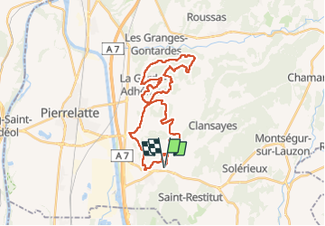
Tocht Mountainbike van 33 km beschikbaar op Auvergne-Rhône-Alpes, Drôme, Saint-Paul-Trois-Châteaux. Deze tocht wordt voorgesteld door charlytan.
Beschrijving
https://cyclotourisme26.org/base-vtt-tricastin-rouge-13/
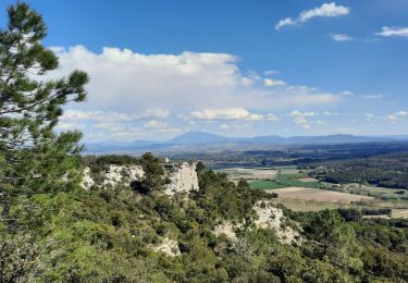
Avec de beaux monotraces et de magnifiques points de vue, vous prendrez de la hauteur au village de la Garde-Adhémar. Une visite s’impose au lieu mystérieux du Val des Nymphes. Vous passerez près des caves lapidaires. Au retour, vous emprunterez de beaux sentiers au bord des vignes et vous traverserez la rivières.
Plaatsbepaling
Opmerkingen
Wandeltochten in de omgeving
![Tocht Stappen Clansayes - SityTrail - Clansayes Le Rouvergue 6km - Photo](https://media.geolcdn.com/t/375/260/de3feb6f-5587-4e87-a580-1261cf3df48e.jpg&format=jpg&maxdim=2)
![Stappen Stappen](https://static1.geolcdn.com/sitytour/trail-icons/101.png)
Stappen
![](/images/other/stat-length.png)
![](https://static1.geolcdn.com/siteimages/upload/files/16400158638029165_repeat_loop_refresh_sync_direction_icon.png)
![Tocht Stappen Saint-Restitut - St Restitut Le Barry 12km - Photo](https://media.geolcdn.com/t/375/260/52d96bcf-650b-4fd0-a59a-69f2b2d3703d.jpg&format=jpg&maxdim=2)
![Stappen Stappen](https://static1.geolcdn.com/sitytour/trail-icons/101.png)
Stappen
![](/images/other/stat-length.png)
![](https://static1.geolcdn.com/siteimages/upload/files/16400158638029165_repeat_loop_refresh_sync_direction_icon.png)
![Tocht Stappen Bollène - Barry Chabrières Enclume 7,5km - Photo](https://media.geolcdn.com/t/375/260/3a4e67d1-088f-449d-b525-af6a45f2f0d7.jpg&format=jpg&maxdim=2)
![Stappen Stappen](https://static1.geolcdn.com/sitytour/trail-icons/101.png)
Stappen
![](/images/other/stat-length.png)
![](https://static1.geolcdn.com/siteimages/upload/files/16400158638029165_repeat_loop_refresh_sync_direction_icon.png)
![Tocht Stappen Saint-Restitut - St Restitut Barry 14km - Photo](https://media.geolcdn.com/t/375/260/919620e4-c2f5-475b-864c-8c28884f4028.jpg&format=jpg&maxdim=2)
![Stappen Stappen](https://static1.geolcdn.com/sitytour/trail-icons/101.png)
Stappen
![](/images/other/stat-length.png)
![](https://static1.geolcdn.com/siteimages/upload/files/16400158638029165_repeat_loop_refresh_sync_direction_icon.png)
![Tocht Stappen Saint-Restitut - Les carrières de Sainte Juste - Saint Restitut - Photo](https://media.geolcdn.com/t/375/260/ext.jpg?maxdim=2&url=https%3A%2F%2Fservices.sitytrail.com%2FGeolivesWS%2FDownloadMedia.ashx%3FTrailID%3D317462%26Media%3D16693_6.jpg)
![Stappen Stappen](https://static1.geolcdn.com/sitytour/trail-icons/101.png)
Stappen
![](/images/other/stat-length.png)
![](https://static1.geolcdn.com/siteimages/upload/files/16400158638029165_repeat_loop_refresh_sync_direction_icon.png)
![Tocht Stappen Suze-la-Rousse - soleirieu - Photo](https://media.geolcdn.com/t/375/260/ext.jpg?maxdim=2&url=https%3A%2F%2Fstatic1.geolcdn.com%2Fsiteimages%2Fupload%2Ffiles%2F1553511878bg_sport_marche.png)
![Stappen Stappen](https://static1.geolcdn.com/sitytour/trail-icons/101.png)
Stappen
![](/images/other/stat-length.png)
![](https://static1.geolcdn.com/siteimages/upload/files/16400158638029165_repeat_loop_refresh_sync_direction_icon.png)
![Tocht Stappen Clansayes - 2022-06-24_19h24m07_Clansayes Le Rouvergue 11km.gpx.xml - Photo](https://media.geolcdn.com/t/375/260/89c952dc-9c57-4311-93c9-63263f0349ef.jpg&format=jpg&maxdim=2)
![Stappen Stappen](https://static1.geolcdn.com/sitytour/trail-icons/101.png)
Stappen
![](/images/other/stat-length.png)
![](https://static1.geolcdn.com/siteimages/upload/files/16400158638029165_repeat_loop_refresh_sync_direction_icon.png)
![Tocht Stappen Clansayes - 2022-05-26_08h43m46_Clansayes Le Rouvergue 8km.gpx.xml - Photo](https://media.geolcdn.com/t/375/260/00183d4b-7799-462e-b9b9-5e3d9f7cb776.jpg&format=jpg&maxdim=2)
![Stappen Stappen](https://static1.geolcdn.com/sitytour/trail-icons/101.png)
Stappen
![](/images/other/stat-length.png)
![](https://static1.geolcdn.com/siteimages/upload/files/16400158638029165_repeat_loop_refresh_sync_direction_icon.png)
![Tocht Stappen Clansayes - SityTrail - 2656269 - chantemerle-clansayes-15km - Photo](https://media.geolcdn.com/t/375/260/10944c4f-f60a-41d6-ab1f-e2a3431a6612.jpg&format=jpg&maxdim=2)
![Stappen Stappen](https://static1.geolcdn.com/sitytour/trail-icons/101.png)
Stappen
![](/images/other/stat-length.png)
![](https://static1.geolcdn.com/siteimages/upload/files/16400158638029165_repeat_loop_refresh_sync_direction_icon.png)