![](/images/other/stat-length.png)
![Tocht Stappen Vaugines - Luberon Vaugines Cucuron - Photo](https://media.geolcdn.com/t/1900/400/6272fad2-dba5-4d24-99de-fd6c5316cc92.jpg&format=pjpeg&maxdim=2)
Luberon Vaugines Cucuron
jll7513
Gebruiker
![Lengte](/images/other/stat-length.png)
![Max. hoogte](https://static1.geolcdn.com/siteimages/upload/files/1508320355ic_sort_altitude_max_24dp.png)
![Positief hoogteverschil](https://static1.geolcdn.com/siteimages/upload/files/1508320355ic_sort_den_pos_24dp.png)
![Km-Effort](/images/other/stat-length.png)
![Min. hoogte](https://static1.geolcdn.com/siteimages/upload/files/1508320355ic_sort_altitude_min_24dp.png)
![Negatief hoogteverschil](https://static1.geolcdn.com/siteimages/upload/files/1508320355ic_sort_den_neg_24dp.png)
![Boucle](https://static1.geolcdn.com/siteimages/upload/files/16400158638029165_repeat_loop_refresh_sync_direction_icon.png)
![Stappen](https://static1.geolcdn.com/sitytour/trail-icons/101.png)
3h11
Moeilijkheid : Gemakkelijk
![Noords wandelen](https://static1.geolcdn.com/sitytour/trail-icons/102.png)
2h05
Moeilijkheid : Gemakkelijk
![Scan deze QR-code om de tocht te openen in de SityTrail-applicatie](https://capi.geolives.com/qq0zvz2zws4bq2lad0pu/sitytour/trails/2904131/qr.png?size=200)
Gratisgps-wandelapplicatie
Over ons
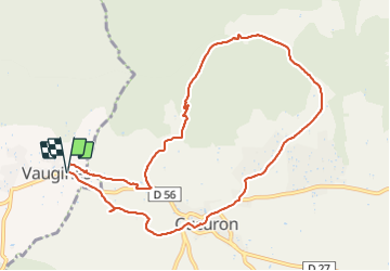
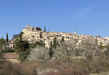
Tocht Stappen van 10,6 km beschikbaar op Provence-Alpes-Côte d'Azur, Vaucluse, Vaugines. Deze tocht wordt voorgesteld door jll7513.
Beschrijving
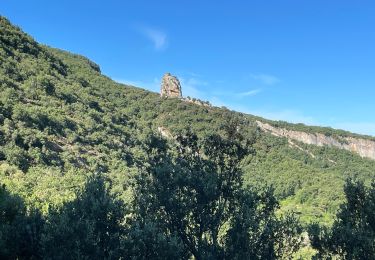
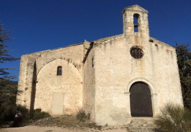
On se gare et on démarre la randonnée depuis le parking dessous l'église de Vaugines. Petit raidillon sur les deux premiers kilomètres, on passe devant la chapelle de l'Hermitage. Ensuite on est sur une large des DFCI pour redescendre et il y a un quart du chemin à faire sur une route goudronnée où il n'y a pas de circulation on est sur les GR9 et GR97. Circuit sympa à faire plutôt de bonheur le matin, dans ce cas il est ombragé.
Plaatsbepaling
Opmerkingen
Wandeltochten in de omgeving
![Tocht Stappen Buoux - PF-Buoux - Sivergues - Le Vallon de l'Aigue Brun - Reco - 01.07.2021 - Photo](https://media.geolcdn.com/t/375/260/fb3b1bc5-2125-42f3-acfd-b4dc3f708a67.jpg&format=jpg&maxdim=2)
![Stappen Stappen](https://static1.geolcdn.com/sitytour/trail-icons/101.png)
Stappen
![](/images/other/stat-length.png)
![](https://static1.geolcdn.com/siteimages/upload/files/16400158638029165_repeat_loop_refresh_sync_direction_icon.png)
![Tocht Stappen Vaugines - PF-Vaugines - Cucuron - l'Ermitage - Vaugines - 17.06.2021 - Photo](https://media.geolcdn.com/t/375/260/49a6fcb0-e7e8-4e10-aa10-ef2270b11aa9.jpg&format=jpg&maxdim=2)
![Stappen Stappen](https://static1.geolcdn.com/sitytour/trail-icons/101.png)
Stappen
![](/images/other/stat-length.png)
![](https://static1.geolcdn.com/siteimages/upload/files/16400158638029165_repeat_loop_refresh_sync_direction_icon.png)
![Stappen Stappen](https://static1.geolcdn.com/sitytour/trail-icons/101.png)
Stappen
![](/images/other/stat-length.png)
![](https://static1.geolcdn.com/siteimages/upload/files/16400158638029165_repeat_loop_refresh_sync_direction_icon.png)
![Stappen Stappen](https://static1.geolcdn.com/sitytour/trail-icons/101.png)
Stappen
![](/images/other/stat-length.png)
![](https://static1.geolcdn.com/siteimages/upload/files/16400158638029165_repeat_loop_refresh_sync_direction_icon.png)
![Tocht Stappen Cadenet - Cadenet -Lourmarin - Photo](https://media.geolcdn.com/t/375/260/f0fee848-9372-4ead-90a1-4f47846561d2.jpg&format=jpg&maxdim=2)
![Stappen Stappen](https://static1.geolcdn.com/sitytour/trail-icons/101.png)
Stappen
![](/images/other/stat-length.png)
![](https://static1.geolcdn.com/siteimages/upload/files/16400158638029165_repeat_loop_refresh_sync_direction_icon.png)
![Tocht Mountainbike Cucuron - Le Coteau des Gamates - Photo](https://media.geolcdn.com/t/375/260/ext.jpg?maxdim=2&url=https%3A%2F%2Fservices.sitytrail.com%2FGeolivesWS%2FDownloadMedia.ashx%3FTrailID%3D108569%26Media%3D1477_1.jpg)
![Mountainbike Mountainbike](https://static1.geolcdn.com/sitytour/trail-icons/202.png)
Mountainbike
![](/images/other/stat-length.png)
![](https://static1.geolcdn.com/siteimages/upload/files/16400158638029165_repeat_loop_refresh_sync_direction_icon.png)
![Tocht Stappen Buoux - 2024-03-15 Buoux - Sivergues - Photo](https://media.geolcdn.com/t/375/260/cee14782-71fc-4a90-896b-8bed906fd77c.jpg&format=jpg&maxdim=2)
![Stappen Stappen](https://static1.geolcdn.com/sitytour/trail-icons/101.png)
Stappen
![](/images/other/stat-length.png)
![](https://static1.geolcdn.com/siteimages/upload/files/16400158638029165_repeat_loop_refresh_sync_direction_icon.png)
![Stappen Stappen](https://static1.geolcdn.com/sitytour/trail-icons/101.png)
Stappen
![](/images/other/stat-length.png)
![](https://static1.geolcdn.com/siteimages/upload/files/16400158638029165_repeat_loop_refresh_sync_direction_icon.png)
![Tocht Stappen Cadenet - PF-Cadenet - De Cadenet à Lourmarin - 3 - Photo](https://media.geolcdn.com/t/375/260/a6ee6e4b-3e12-4299-848e-3348098a84d0.jpg&format=jpg&maxdim=2)
![Stappen Stappen](https://static1.geolcdn.com/sitytour/trail-icons/101.png)
Stappen
![](/images/other/stat-length.png)
![](https://static1.geolcdn.com/siteimages/upload/files/16400158638029165_repeat_loop_refresh_sync_direction_icon.png)