![](/images/other/stat-length.png)
![Tocht Stappen Saint-Beauzély - Azinieres - Photo](https://media.geolcdn.com/t/1900/400/1dfbadc8-e0fb-4e6a-88b1-8eff9b9fd955.jpg&format=pjpeg&maxdim=2)
Azinieres
Sandrine Micou
Gebruiker
![Lengte](/images/other/stat-length.png)
Lengte
17,4 km
![Max. hoogte](https://static1.geolcdn.com/siteimages/upload/files/1508320355ic_sort_altitude_max_24dp.png)
Max. hoogte
789 m
![Positief hoogteverschil](https://static1.geolcdn.com/siteimages/upload/files/1508320355ic_sort_den_pos_24dp.png)
Positief hoogteverschil
350 m
![Km-Effort](/images/other/stat-length.png)
Km-Effort
22 km
![Min. hoogte](https://static1.geolcdn.com/siteimages/upload/files/1508320355ic_sort_altitude_min_24dp.png)
Min. hoogte
676 m
![Negatief hoogteverschil](https://static1.geolcdn.com/siteimages/upload/files/1508320355ic_sort_den_neg_24dp.png)
Negatief hoogteverschil
346 m
![Boucle](https://static1.geolcdn.com/siteimages/upload/files/16400158638029165_repeat_loop_refresh_sync_direction_icon.png)
Boucle
Ja
Datum van aanmaak :
2021-08-17 08:29:52.0
Laatste wijziging :
2021-08-17 13:28:58.96
![Stappen](https://static1.geolcdn.com/sitytour/trail-icons/101.png)
4h57
Moeilijkheid : Medium
![Scan deze QR-code om de tocht te openen in de SityTrail-applicatie](https://capi.geolives.com/qq0zvz2zws4bq2lad0pu/sitytour/trails/2901904/qr.png?size=200)
Gratisgps-wandelapplicatie
Over ons
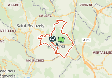
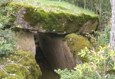
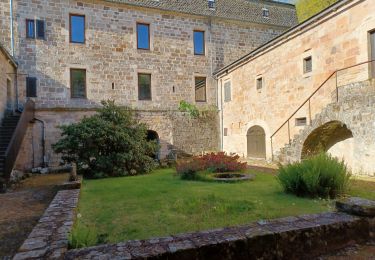
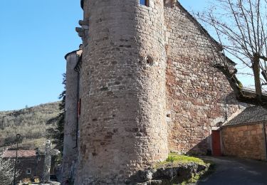
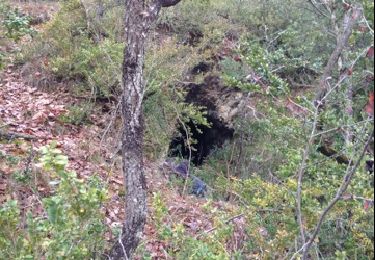
Tocht Stappen van 17,4 km beschikbaar op Occitanië, Aveyron, Saint-Beauzély. Deze tocht wordt voorgesteld door Sandrine Micou.
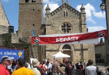
Beschrijving
Belle randonnée
Très peu balisé,prévoir un gps et batterie de portable pleine.
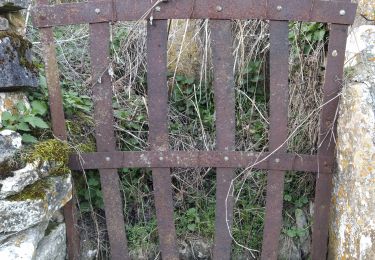
Des barrières vous empêchent de continuer le parcours !!!!!!
Plaatsbepaling
Land:
France
Regio :
Occitanië
Departement/Provincie :
Aveyron
Gemeente :
Saint-Beauzély
Locatie:
Unknown
Vertrek:(Dec)
Vertrek:(UTM)
499138 ; 4888657 (31T) N.
Opmerkingen
Wandeltochten in de omgeving
![Tocht Stappen Millau - Randonnée autour du Viaduc de Millau - Photo](https://media.geolcdn.com/t/375/260/ext.jpg?maxdim=2&url=https%3A%2F%2Fservices.sitytrail.com%2FGeolivesWS%2FDownloadMedia.ashx%3FTrailID%3D103144%26Media%3D4952_6.jpg)
![Stappen Stappen](https://static1.geolcdn.com/sitytour/trail-icons/101.png)
Randonnée autour du Viaduc de Millau
Stappen
Moeilijk
(2)
Millau,
Occitanië,
Aveyron,
France
![](/images/other/stat-length.png)
18,5 km | 26 km-effort
5h 30min
![](https://static1.geolcdn.com/siteimages/upload/files/16400158638029165_repeat_loop_refresh_sync_direction_icon.png)
Ja
![Tocht Lopen Saint-Beauzély - Trail de la Muse - Saint Beauzély - Photo](https://media.geolcdn.com/t/375/260/ext.jpg?maxdim=2&url=https%3A%2F%2Fservices.sitytrail.com%2FGeolivesWS%2FDownloadMedia.ashx%3FTrailID%3D104948%26Media%3D8490_4.jpg)
![Lopen Lopen](https://static1.geolcdn.com/sitytour/trail-icons/103.png)
Trail de la Muse - Saint Beauzély
Lopen
Moeilijk
Saint-Beauzély,
Occitanië,
Aveyron,
France
![](/images/other/stat-length.png)
24 km | 36 km-effort
3h 30min
![](https://static1.geolcdn.com/siteimages/upload/files/16400158638029165_repeat_loop_refresh_sync_direction_icon.png)
Ja
![Tocht Stappen Saint-Beauzély - Trail de la Muse - Saint Beauzély - Photo](https://media.geolcdn.com/t/375/260/ext.jpg?maxdim=2&url=https%3A%2F%2Fservices.sitytrail.com%2FGeolivesWS%2FDownloadMedia.ashx%3FTrailID%3D104947%26Media%3D8490_4.jpg)
![Stappen Stappen](https://static1.geolcdn.com/sitytour/trail-icons/101.png)
Trail de la Muse - Saint Beauzély
Stappen
Moeilijk
Saint-Beauzély,
Occitanië,
Aveyron,
France
![](/images/other/stat-length.png)
24 km | 36 km-effort
5h 30min
![](https://static1.geolcdn.com/siteimages/upload/files/16400158638029165_repeat_loop_refresh_sync_direction_icon.png)
Ja
![Tocht Stappen Saint-Beauzély - Azinières, les dix Cazelles - Photo](https://media.geolcdn.com/t/375/260/ext.jpg?maxdim=2&url=https%3A%2F%2Fservices.sitytrail.com%2FGeolivesWS%2FDownloadMedia.ashx%3FTrailID%3D103252%26Media%3D5201_6.jpg)
![Stappen Stappen](https://static1.geolcdn.com/sitytour/trail-icons/101.png)
Azinières, les dix Cazelles
Stappen
Medium
(2)
Saint-Beauzély,
Occitanië,
Aveyron,
France
![](/images/other/stat-length.png)
13,1 km | 17,2 km-effort
3h 30min
![](https://static1.geolcdn.com/siteimages/upload/files/16400158638029165_repeat_loop_refresh_sync_direction_icon.png)
Ja
![Tocht Stappen Saint-Beauzély - St beauz cloître beaumette St b - Photo](https://media.geolcdn.com/t/375/260/7d8002ed-6d7a-42e8-a6e2-cb0b15e22ed0.jpg&format=jpg&maxdim=2)
![Stappen Stappen](https://static1.geolcdn.com/sitytour/trail-icons/101.png)
St beauz cloître beaumette St b
Stappen
Moeilijk
(1)
Saint-Beauzély,
Occitanië,
Aveyron,
France
![](/images/other/stat-length.png)
8,5 km | 12,5 km-effort
1h 46min
![](https://static1.geolcdn.com/siteimages/upload/files/16400158638029165_repeat_loop_refresh_sync_direction_icon.png)
Ja
![Tocht Lopen Castelnau-Pégayrols - moulibez castelneau peg castelmus moulibez - Photo](https://media.geolcdn.com/t/375/260/c71b2188-35db-49da-b90c-27cdee8e0de7.jpg&format=jpg&maxdim=2)
![Lopen Lopen](https://static1.geolcdn.com/sitytour/trail-icons/103.png)
moulibez castelneau peg castelmus moulibez
Lopen
Heel gemakkelijk
Castelnau-Pégayrols,
Occitanië,
Aveyron,
France
![](/images/other/stat-length.png)
10,6 km | 15,7 km-effort
2h 6min
![](https://static1.geolcdn.com/siteimages/upload/files/16400158638029165_repeat_loop_refresh_sync_direction_icon.png)
Ja
![Tocht Stappen Millau - Soulobres Therondels Peyre - Photo](https://media.geolcdn.com/t/375/260/38edd2a6-cf83-49ed-8f77-fbdf89c4906d.jpg&format=jpg&maxdim=2)
![Stappen Stappen](https://static1.geolcdn.com/sitytour/trail-icons/101.png)
Soulobres Therondels Peyre
Stappen
Heel gemakkelijk
Millau,
Occitanië,
Aveyron,
France
![](/images/other/stat-length.png)
11,2 km | 17,6 km-effort
2h 50min
![](https://static1.geolcdn.com/siteimages/upload/files/16400158638029165_repeat_loop_refresh_sync_direction_icon.png)
Ja
![Tocht Stappen Millau - galettes chapelle de brocuejouls - Photo](https://media.geolcdn.com/t/375/260/ext.jpg?maxdim=2&url=https%3A%2F%2Fservices.sitytrail.com%2FGeolivesWS%2FDownloadMedia.ashx%3FTrailID%3D169123%26Media%3D20130107144720.jpg)
![Stappen Stappen](https://static1.geolcdn.com/sitytour/trail-icons/101.png)
galettes chapelle de brocuejouls
Stappen
Heel gemakkelijk
Millau,
Occitanië,
Aveyron,
France
![](/images/other/stat-length.png)
6,7 km | 8,6 km-effort
1h 52min
![](https://static1.geolcdn.com/siteimages/upload/files/16400158638029165_repeat_loop_refresh_sync_direction_icon.png)
Neen
![Tocht Moto-cross Millau - 2jours 2021 j1 - Photo](https://media.geolcdn.com/t/375/260/ext.jpg?maxdim=2&url=https%3A%2F%2Fstatic1.geolcdn.com%2Fsiteimages%2Fupload%2Ffiles%2F1524743155moto.jpg)
![Moto-cross Moto-cross](https://static1.geolcdn.com/sitytour/trail-icons/406.png)
2jours 2021 j1
Moto-cross
Heel gemakkelijk
Millau,
Occitanië,
Aveyron,
France
![](/images/other/stat-length.png)
73 km | 93 km-effort
2h 0min
![](https://static1.geolcdn.com/siteimages/upload/files/16400158638029165_repeat_loop_refresh_sync_direction_icon.png)
Neen