Tocht Mountainbike Lourmarin - Lourmarin - Bonnieux- Buoux- Aigues Brun - Photo

Lourmarin - Bonnieux- Buoux- Aigues Brun

 DG01
DG01

Gebruiker

© OpenStreetMap contributors
Lengte
Lengte
43 km
Max. hoogte
Max. hoogte
653 m
Positief hoogteverschil
1124 m
Km-Effort
Km-Effort  
58 km
Min. hoogte
Min. hoogte
201 m
Negatief hoogteverschil
1150 m
Boucle
Boucle
Neen
Datum van aanmaak :
2021-08-14 05:41:20.0
Laatste wijziging :
2021-08-14 11:31:08.874

(0 Bericht)

Mountainbike
Mountainbike
4h00
Moeilijkheid : Moeilijk

Scan deze QR-code om de tocht te openen in de SityTrail-applicatie

Gratisgps-wandelapplicatie

Logo SityTrail SityTrail

IGN / Geografische instituten

SityTrail uit de App Store downloaden SityTrail uit Google Play downloaden

Logo SityTrail SityTrail World

De wereld gaat voor u open

SityTrail uit de App Store downloaden SityTrail uit Google Play downloaden SityTrail op Huawei AppGallery downloaden

Over ons

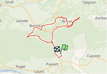
Tocht Mountainbike van 43 km beschikbaar op Provence-Alpes-Côte d'Azur, Vaucluse, Lourmarin. Deze tocht wordt voorgesteld door DG01.

Beschrijving

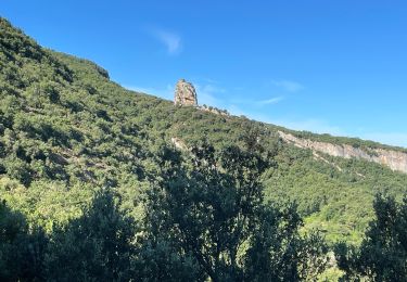
Magnifiques vues et singles.
Descente depuis le Petit Luberon très caillouteuse mais ça passe, montée depuis le camping de Bonnieux où il faut pousser le vélo (pas très long), single en haut des falaises de Buoux et retour le long de l’Aigues Brun super sympa.

Hoogteprofiel

Plaatsbepaling

Land:
France
Regio :
Provence-Alpes-Côte d'Azur
Departement/Provincie :
Vaucluse
Gemeente :
Lourmarin
Locatie:
Unknown
Vertrek:(Dec)
Vertrek:(UTM)
690162 ; 4849694 (31T) N.

Wandeltochten in de omgeving

Tocht Stappen Cadenet - Cadenet -Lourmarin - Photo
Stappen

Stappen

Heel gemakkelijk
(1)
Cadenet, Provence-Alpes-Côte d'Azur, Vaucluse, France
12,1 km | 15,3 km-effort
5h 43min
Ja
Tocht Stappen Buoux - 2024-03-15 Buoux - Sivergues - Photo
Stappen
GUIDE
Kargil

Stappen

Moeilijk
Buoux, Provence-Alpes-Côte d'Azur, Vaucluse, France
16,7 km | 25 km-effort
5h 42min
Ja
Tocht Stappen Buoux - L'Aiguebrun Sivergues - Photo
Stappen
GUIDE
amiral13

Stappen

Heel gemakkelijk
(1)
Buoux, Provence-Alpes-Côte d'Azur, Vaucluse, France
8 km | 10,8 km-effort
6h 20min
Ja
Tocht Stappen Vaugines - Vaugines - roque rousse. -  Vaugines - Photo
Stappen
Dadou 1

Stappen

Medium
Vaugines, Provence-Alpes-Côte d'Azur, Vaucluse, France
6 km | 9 km-effort
2h 3min
Ja
Tocht Stappen Vaugines - SityTrail - PF-Vaugines - Le Mourre Nègre à partir de Vaugines - Var - Photo
Stappen
MicDul

Stappen

Zeer moeilijk
(1)
Vaugines, Provence-Alpes-Côte d'Azur, Vaucluse, France
20 km | 32 km-effort
7h 14min
Ja
Tocht Stappen Buoux - Seguins-Sivergues 18.3.23 - Photo
Stappen
GUIDE
fredetpascale

Stappen

Gemakkelijk
Buoux, Provence-Alpes-Côte d'Azur, Vaucluse, France
8,8 km | 12,4 km-effort
2h 30min
Ja
Tocht Te voet Lourmarin - Lourmarin - Cadenet - Lourmarin  - Photo
Te voet
Dadou 1

Te voet

Gemakkelijk
Lourmarin, Provence-Alpes-Côte d'Azur, Vaucluse, France
11,5 km | 14,6 km-effort
3h 19min
Ja
Tocht Stappen Vaugines - Luberon Vaugines Cucuron  - Photo
Stappen
jll7513

Stappen

Gemakkelijk
Vaugines, Provence-Alpes-Côte d'Azur, Vaucluse, France
10,6 km | 14 km-effort
3h 11min
Ja
Tocht Stappen Buoux - PF-Buoux - Sivergues - Le Vallon de l'Aigue Brun - Reco - 01.07.2021 - Photo
Stappen
MicDul

Stappen

Medium
(1)
Buoux, Provence-Alpes-Côte d'Azur, Vaucluse, France
7,3 km | 10,1 km-effort
1h 58min
Ja


Sluiten
Mijn abonnementen