![](/images/other/stat-length.png)
![Tocht Noords wandelen Velaine-sous-Amance - Velaine-sous-Amance 10 030m +120m - Photo](https://media.geolcdn.com/t/1900/400/ext.pjpeg?maxdim=2&url=https%3A%2F%2Fstatic1.geolcdn.com%2Fsiteimages%2Fupload%2Ffiles%2F1545311037marcheuse_200dpi.jpg)
Velaine-sous-Amance 10 030m +120m
DanielROLLET
Gebruiker
![Lengte](/images/other/stat-length.png)
Lengte
10 km
![Max. hoogte](https://static1.geolcdn.com/siteimages/upload/files/1508320355ic_sort_altitude_max_24dp.png)
Max. hoogte
275 m
![Positief hoogteverschil](https://static1.geolcdn.com/siteimages/upload/files/1508320355ic_sort_den_pos_24dp.png)
Positief hoogteverschil
120 m
![Km-Effort](/images/other/stat-length.png)
Km-Effort
11,6 km
![Min. hoogte](https://static1.geolcdn.com/siteimages/upload/files/1508320355ic_sort_altitude_min_24dp.png)
Min. hoogte
222 m
![Negatief hoogteverschil](https://static1.geolcdn.com/siteimages/upload/files/1508320355ic_sort_den_neg_24dp.png)
Negatief hoogteverschil
120 m
![Boucle](https://static1.geolcdn.com/siteimages/upload/files/16400158638029165_repeat_loop_refresh_sync_direction_icon.png)
Boucle
Ja
Datum van aanmaak :
2021-08-12 06:53:05.742
Laatste wijziging :
2021-08-12 09:55:15.887
![Noords wandelen](https://static1.geolcdn.com/sitytour/trail-icons/102.png)
2h05
Moeilijkheid : Heel gemakkelijk
![Scan deze QR-code om de tocht te openen in de SityTrail-applicatie](https://capi.geolives.com/qq0zvz2zws4bq2lad0pu/sitytour/trails/2895025/qr.png?size=200)
Gratisgps-wandelapplicatie
Over ons
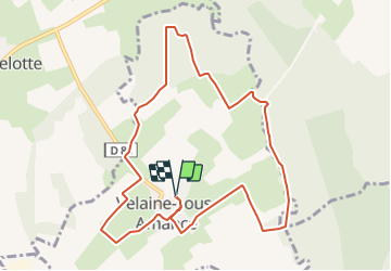
Tocht Noords wandelen van 10 km beschikbaar op Grand Est, Meurthe-et-Moselle, Velaine-sous-Amance. Deze tocht wordt voorgesteld door DanielROLLET.
Beschrijving
2021 08 12 Marche nordique - 8h55 à 11h00
Beau temps
6 participants
Plaatsbepaling
Land:
France
Regio :
Grand Est
Departement/Provincie :
Meurthe-et-Moselle
Gemeente :
Velaine-sous-Amance
Locatie:
Unknown
Vertrek:(Dec)
Vertrek:(UTM)
303096 ; 5399206 (32U) N.
Opmerkingen
Wandeltochten in de omgeving
![Tocht Lopen Pulnoy - Parcours de santé PULNOY - Photo](https://media.geolcdn.com/t/375/260/ext.jpg?maxdim=2&url=https%3A%2F%2Fservices.sitytrail.com%2FGeolivesWS%2FDownloadMedia.ashx%3FTrailID%3D206190%26Media%3D20130720101848.jpg)
![Lopen Lopen](https://static1.geolcdn.com/sitytour/trail-icons/103.png)
Parcours de santé PULNOY
Lopen
Heel gemakkelijk
(1)
Pulnoy,
Grand Est,
Meurthe-et-Moselle,
France
![](/images/other/stat-length.png)
4,8 km | 6 km-effort
58min
![](https://static1.geolcdn.com/siteimages/upload/files/16400158638029165_repeat_loop_refresh_sync_direction_icon.png)
Ja
![Tocht Hybride fiets Seichamps - Tonnoy - Photo](https://media.geolcdn.com/t/375/260/ext.jpg?maxdim=2&url=https%3A%2F%2Fstatic1.geolcdn.com%2Fsiteimages%2Fupload%2Ffiles%2F1524743154velo.jpg)
![Hybride fiets Hybride fiets](https://static1.geolcdn.com/sitytour/trail-icons/203.png)
Tonnoy
Hybride fiets
Medium
(1)
Seichamps,
Grand Est,
Meurthe-et-Moselle,
France
![](/images/other/stat-length.png)
54 km | 61 km-effort
3h 42min
![](https://static1.geolcdn.com/siteimages/upload/files/16400158638029165_repeat_loop_refresh_sync_direction_icon.png)
Ja
![Tocht Noords wandelen Pulnoy - Foulée des Rois Pulnoy 2024 - Photo](https://media.geolcdn.com/t/375/260/0aebb121-6259-49b0-a2db-f92183a3506b.jpg&format=jpg&maxdim=2)
![Noords wandelen Noords wandelen](https://static1.geolcdn.com/sitytour/trail-icons/102.png)
Foulée des Rois Pulnoy 2024
Noords wandelen
Medium
Pulnoy,
Grand Est,
Meurthe-et-Moselle,
France
![](/images/other/stat-length.png)
9,9 km | 12,5 km-effort
1h 45min
![](https://static1.geolcdn.com/siteimages/upload/files/16400158638029165_repeat_loop_refresh_sync_direction_icon.png)
Ja
![Tocht Stappen Amance - Bouzule 13400m + 290m - Photo](https://media.geolcdn.com/t/375/260/ext.jpg?maxdim=2&url=https%3A%2F%2Fservices.sitytrail.com%2FGeolivesWS%2FDownloadMedia.ashx%3FTrailID%3D750365%26Media%3Dfix__20170510170945.jpg)
![Stappen Stappen](https://static1.geolcdn.com/sitytour/trail-icons/101.png)
Bouzule 13400m + 290m
Stappen
Gemakkelijk
Amance,
Grand Est,
Meurthe-et-Moselle,
France
![](/images/other/stat-length.png)
13,2 km | 16,9 km-effort
3h 41min
![](https://static1.geolcdn.com/siteimages/upload/files/16400158638029165_repeat_loop_refresh_sync_direction_icon.png)
Ja
![Tocht Stappen Amance - Brin - Photo](https://media.geolcdn.com/t/375/260/ext.jpg?maxdim=2&url=https%3A%2F%2Fservices.sitytrail.com%2FGeolivesWS%2FDownloadMedia.ashx%3FTrailID%3D389906%26Media%3Dfix__20150225142115.jpg)
![Stappen Stappen](https://static1.geolcdn.com/sitytour/trail-icons/101.png)
Brin
Stappen
Gemakkelijk
Amance,
Grand Est,
Meurthe-et-Moselle,
France
![](/images/other/stat-length.png)
11,4 km | 13,1 km-effort
2h 57min
![](https://static1.geolcdn.com/siteimages/upload/files/16400158638029165_repeat_loop_refresh_sync_direction_icon.png)
Ja