![](/images/other/stat-length.png)
![Tocht Stappen Blieberg - Plombière (3 frontières) 13 / 250 ♥ - Photo](https://media.geolcdn.com/t/1900/400/ext.pjpeg?maxdim=2&url=https%3A%2F%2Fstatic1.geolcdn.com%2Fsiteimages%2Fupload%2Ffiles%2F1553511878bg_sport_marche.png)
Plombière (3 frontières) 13 / 250 ♥
Jeanedouard
Gebruiker
![Lengte](/images/other/stat-length.png)
Lengte
12,8 km
![Max. hoogte](https://static1.geolcdn.com/siteimages/upload/files/1508320355ic_sort_altitude_max_24dp.png)
Max. hoogte
345 m
![Positief hoogteverschil](https://static1.geolcdn.com/siteimages/upload/files/1508320355ic_sort_den_pos_24dp.png)
Positief hoogteverschil
250 m
![Km-Effort](/images/other/stat-length.png)
Km-Effort
16,2 km
![Min. hoogte](https://static1.geolcdn.com/siteimages/upload/files/1508320355ic_sort_altitude_min_24dp.png)
Min. hoogte
148 m
![Negatief hoogteverschil](https://static1.geolcdn.com/siteimages/upload/files/1508320355ic_sort_den_neg_24dp.png)
Negatief hoogteverschil
251 m
![Boucle](https://static1.geolcdn.com/siteimages/upload/files/16400158638029165_repeat_loop_refresh_sync_direction_icon.png)
Boucle
Ja
Datum van aanmaak :
2021-08-08 10:14:41.974
Laatste wijziging :
2023-08-02 14:11:20.969
![Stappen](https://static1.geolcdn.com/sitytour/trail-icons/101.png)
2h16
Moeilijkheid : Medium
![Scan deze QR-code om de tocht te openen in de SityTrail-applicatie](https://capi.geolives.com/qq0zvz2zws4bq2lad0pu/sitytour/trails/2889744/qr.png?size=200)
Gratisgps-wandelapplicatie
Over ons
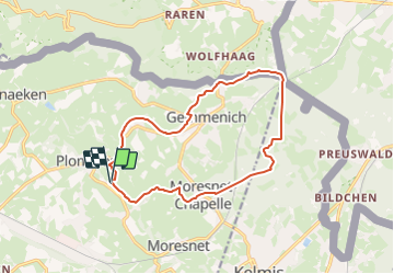
Tocht Stappen van 12,8 km beschikbaar op Wallonië, Luik, Blieberg. Deze tocht wordt voorgesteld door Jeanedouard.
Beschrijving
Départ = rue de la Galène → Parking à l'arrière de ma maison communale ♥
Longueur = 13 km → KE = 16 km ♥
Alt = 148 / 345 m
DC = 250 m
Plaatsbepaling
Land:
Belgium
Regio :
Wallonië
Departement/Provincie :
Luik
Gemeente :
Blieberg
Locatie:
Unknown
Vertrek:(Dec)
Vertrek:(UTM)
709372 ; 5624357 (31U) N.
Opmerkingen
Wandeltochten in de omgeving
![Tocht Stappen Blieberg - Hombourg. Natura 2000, des sites qui valent le détour ! Lg6 - Photo](https://media.geolcdn.com/t/375/260/ext.jpg?maxdim=2&url=https%3A%2F%2Fservices.sitytrail.com%2FGeolivesWS%2FDownloadMedia.ashx%3FTrailID%3D142693%26Media%3D08dbd372-9409-44af-92fd-51b9576d1e78.JPG)
![Stappen Stappen](https://static1.geolcdn.com/sitytour/trail-icons/101.png)
Hombourg. Natura 2000, des sites qui valent le détour ! Lg6
Stappen
Gemakkelijk
(10)
Blieberg,
Wallonië,
Luik,
Belgium
![](/images/other/stat-length.png)
9,5 km | 12 km-effort
2h 35min
![](https://static1.geolcdn.com/siteimages/upload/files/16400158638029165_repeat_loop_refresh_sync_direction_icon.png)
Ja
![Tocht Stappen Gulpen-Wittem - 2024-10-26_19h39m19_1518.gpx.xml - Photo](https://media.geolcdn.com/t/375/260/8521698d-6278-4db9-b85e-3d349e5101aa.jpg&format=jpg&maxdim=2)
![Stappen Stappen](https://static1.geolcdn.com/sitytour/trail-icons/101.png)
2024-10-26_19h39m19_1518.gpx.xml
Stappen
Medium
(1)
Gulpen-Wittem,
Limburg,
Onbekend,
Netherlands
![](/images/other/stat-length.png)
6,6 km | 8,9 km-effort
2h 0min
![](https://static1.geolcdn.com/siteimages/upload/files/16400158638029165_repeat_loop_refresh_sync_direction_icon.png)
Ja
![Tocht Stappen Kelmis - Le pays calaminaire - Photo](https://media.geolcdn.com/t/375/260/30655fe2-e81a-47ed-96f4-20092bed94b7.jpg&format=jpg&maxdim=2)
![Stappen Stappen](https://static1.geolcdn.com/sitytour/trail-icons/101.png)
Le pays calaminaire
Stappen
Medium
(1)
Kelmis,
Wallonië,
Luik,
Belgium
![](/images/other/stat-length.png)
9,6 km | 12,1 km-effort
2h 44min
![](https://static1.geolcdn.com/siteimages/upload/files/16400158638029165_repeat_loop_refresh_sync_direction_icon.png)
Ja
![Tocht Stappen Gulpen-Wittem - Epen - Vijlen - Mechelen - Photo](https://media.geolcdn.com/t/375/260/5bb62a81-94e0-4aeb-8671-819fde7ee6b3.jpg&format=jpg&maxdim=2)
![Stappen Stappen](https://static1.geolcdn.com/sitytour/trail-icons/101.png)
Epen - Vijlen - Mechelen
Stappen
Gemakkelijk
(1)
Gulpen-Wittem,
Limburg,
Onbekend,
Netherlands
![](/images/other/stat-length.png)
13,9 km | 17,5 km-effort
3h 9min
![](https://static1.geolcdn.com/siteimages/upload/files/16400158638029165_repeat_loop_refresh_sync_direction_icon.png)
Ja
![Tocht Stappen Kelmis - La Calamine - Photo](https://media.geolcdn.com/t/375/260/606e5792-434a-491a-b5eb-2bfc2ef6f1ed.jpg&format=jpg&maxdim=2)
![Stappen Stappen](https://static1.geolcdn.com/sitytour/trail-icons/101.png)
La Calamine
Stappen
Gemakkelijk
(1)
Kelmis,
Wallonië,
Luik,
Belgium
![](/images/other/stat-length.png)
9,1 km | 11,6 km-effort
2h 38min
![](https://static1.geolcdn.com/siteimages/upload/files/16400158638029165_repeat_loop_refresh_sync_direction_icon.png)
Ja
![Stappen Stappen](https://static1.geolcdn.com/sitytour/trail-icons/101.png)
20220428 - Bois de Hess 6.7 Km
Stappen
Medium
(1)
Blieberg,
Wallonië,
Luik,
Belgium
![](/images/other/stat-length.png)
6,7 km | 8,4 km-effort
3h 11min
![](https://static1.geolcdn.com/siteimages/upload/files/16400158638029165_repeat_loop_refresh_sync_direction_icon.png)
Ja
![Tocht Stappen Kelmis - 2022-01-18_14h17m25_kelmis - Photo](https://media.geolcdn.com/t/375/260/9eea9d75-ea39-4660-b255-7d2a2255555e.jpg&format=jpg&maxdim=2)
![Stappen Stappen](https://static1.geolcdn.com/sitytour/trail-icons/101.png)
2022-01-18_14h17m25_kelmis
Stappen
Gemakkelijk
(1)
Kelmis,
Wallonië,
Luik,
Belgium
![](/images/other/stat-length.png)
14,2 km | 18,4 km-effort
4h 10min
![](https://static1.geolcdn.com/siteimages/upload/files/16400158638029165_repeat_loop_refresh_sync_direction_icon.png)
Ja
![Tocht Stappen Gulpen-Wittem - 2021-07-01_12h32m15_730 - Photo](https://media.geolcdn.com/t/375/260/6d525f96-e75b-473b-8ed3-0e3441be1b34.jpg&format=jpg&maxdim=2)
![Stappen Stappen](https://static1.geolcdn.com/sitytour/trail-icons/101.png)
2021-07-01_12h32m15_730
Stappen
Gemakkelijk
(1)
Gulpen-Wittem,
Limburg,
Onbekend,
Netherlands
![](/images/other/stat-length.png)
21 km | 26 km-effort
5h 59min
![](https://static1.geolcdn.com/siteimages/upload/files/16400158638029165_repeat_loop_refresh_sync_direction_icon.png)
Ja
![Tocht Stappen Kelmis - 20200730 - Les 3 Bornes 7.3 Km - Photo](https://media.geolcdn.com/t/375/260/ab7b3f98-4235-4a73-ba70-1bedd5c785f3.jpg&format=jpg&maxdim=2)
![Stappen Stappen](https://static1.geolcdn.com/sitytour/trail-icons/101.png)
20200730 - Les 3 Bornes 7.3 Km
Stappen
Moeilijk
(1)
Kelmis,
Wallonië,
Luik,
Belgium
![](/images/other/stat-length.png)
7,4 km | 10,4 km-effort
1h 50min
![](https://static1.geolcdn.com/siteimages/upload/files/16400158638029165_repeat_loop_refresh_sync_direction_icon.png)
Ja