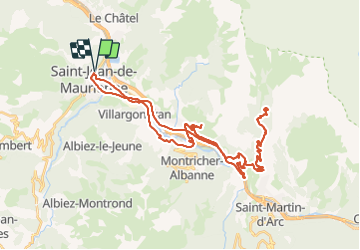
![](/images/other/stat-length.png)
![Tocht Wegfiets Saint-Jean-de-Maurienne - Chaburtan - Photo](https://media.geolcdn.com/t/1900/400/28be9886-2421-4baa-a81c-d04bd93a111b.jpg&format=pjpeg&maxdim=2)
Chaburtan
nadd73
Gebruiker GUIDE
![Lengte](/images/other/stat-length.png)
![Max. hoogte](https://static1.geolcdn.com/siteimages/upload/files/1508320355ic_sort_altitude_max_24dp.png)
![Positief hoogteverschil](https://static1.geolcdn.com/siteimages/upload/files/1508320355ic_sort_den_pos_24dp.png)
![Km-Effort](/images/other/stat-length.png)
![Min. hoogte](https://static1.geolcdn.com/siteimages/upload/files/1508320355ic_sort_altitude_min_24dp.png)
![Negatief hoogteverschil](https://static1.geolcdn.com/siteimages/upload/files/1508320355ic_sort_den_neg_24dp.png)
![Boucle](https://static1.geolcdn.com/siteimages/upload/files/16400158638029165_repeat_loop_refresh_sync_direction_icon.png)
![Wegfiets](https://static1.geolcdn.com/sitytour/trail-icons/201.png)
5h43
Moeilijkheid : Medium
![Scan deze QR-code om de tocht te openen in de SityTrail-applicatie](https://capi.geolives.com/qq0zvz2zws4bq2lad0pu/sitytour/trails/2876056/qr.png?size=200)
Gratisgps-wandelapplicatie
Over ons
Tocht Wegfiets van 47 km beschikbaar op Auvergne-Rhône-Alpes, Savoie, Saint-Jean-de-Maurienne. Deze tocht wordt voorgesteld door nadd73.
Beschrijving
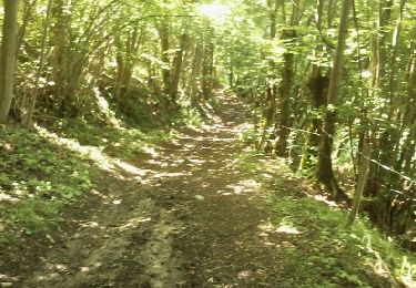
A l'allée j'ai voulu prendre dès Petites routes car il y avait des travaux sur la N mais je me suis retrouvée le long du canal dans un chemin forestier donc le vélo de course n'a pas trop apprécié.
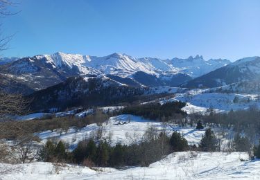
La fin comporte des pentes très raides. Sinon très joli et calme (à partir de Saint Martin de la porte).
Plaatsbepaling
Opmerkingen
Wandeltochten in de omgeving
![Tocht Mountainbike La Tour-en-Maurienne - Le châtel-Le Chaussy-Le Melezet - Photo](https://media.geolcdn.com/t/375/260/ext.jpg?maxdim=2&url=https%3A%2F%2Fservices.sitytrail.com%2FGeolivesWS%2FDownloadMedia.ashx%3FTrailID%3D204099%26Media%3Dfix__20130711114109.jpg)
![Mountainbike Mountainbike](https://static1.geolcdn.com/sitytour/trail-icons/202.png)
Mountainbike
![](/images/other/stat-length.png)
![](https://static1.geolcdn.com/siteimages/upload/files/16400158638029165_repeat_loop_refresh_sync_direction_icon.png)
![Tocht Stappen Jarrier - le grand Chatelard - Photo](https://media.geolcdn.com/t/375/260/ext.jpg?maxdim=2&url=https%3A%2F%2Fservices.sitytrail.com%2FGeolivesWS%2FDownloadMedia.ashx%3FTrailID%3D142418%26Media%3D20120730134347.jpg)
![Stappen Stappen](https://static1.geolcdn.com/sitytour/trail-icons/101.png)
Stappen
![](/images/other/stat-length.png)
![](https://static1.geolcdn.com/siteimages/upload/files/16400158638029165_repeat_loop_refresh_sync_direction_icon.png)
![Tocht Sneeuwschoenen Saint-Pancrace - les Bottieres - La Cochette - la Verpilliere Les Chenaviers - Photo](https://media.geolcdn.com/t/375/260/840632dc-15ea-423f-8ff5-5b7618383fc5.jpg&format=jpg&maxdim=2)
![Sneeuwschoenen Sneeuwschoenen](https://static1.geolcdn.com/sitytour/trail-icons/504.png)
Sneeuwschoenen
![](/images/other/stat-length.png)
![](https://static1.geolcdn.com/siteimages/upload/files/16400158638029165_repeat_loop_refresh_sync_direction_icon.png)
![Tocht Stappen Albiez-le-Jeune - croix d Albiez - crête de Lacha - Photo](https://media.geolcdn.com/t/375/260/431fcdd6-98c0-42c3-965e-077f94a069d4.jpg&format=jpg&maxdim=2)
![Stappen Stappen](https://static1.geolcdn.com/sitytour/trail-icons/101.png)
Stappen
![](/images/other/stat-length.png)
![](https://static1.geolcdn.com/siteimages/upload/files/16400158638029165_repeat_loop_refresh_sync_direction_icon.png)
![Tocht Stappen La Tour-en-Maurienne - Le Golet - Montandre- chapelle de Grenis - Photo](https://media.geolcdn.com/t/375/260/13d19fed-b851-4a24-9e73-845cc4a770c1.jpg&format=jpg&maxdim=2)
![Stappen Stappen](https://static1.geolcdn.com/sitytour/trail-icons/101.png)
Stappen
![](/images/other/stat-length.png)
![](https://static1.geolcdn.com/siteimages/upload/files/16400158638029165_repeat_loop_refresh_sync_direction_icon.png)
![Tocht Trail Saint-Julien-Mont-Denis - Tour des ardoisières, Montdenis - Photo](https://media.geolcdn.com/t/375/260/ext.jpg?maxdim=2&url=https%3A%2F%2Fstatic1.geolcdn.com%2Fsiteimages%2Fupload%2Ffiles%2F1524743154running.jpg)
![Trail Trail](https://static1.geolcdn.com/sitytour/trail-icons/104.png)
Trail
![](/images/other/stat-length.png)
![](https://static1.geolcdn.com/siteimages/upload/files/16400158638029165_repeat_loop_refresh_sync_direction_icon.png)
![Tocht Stappen Saint-Julien-Mont-Denis - Chemin des Ardoisiers - Photo](https://media.geolcdn.com/t/375/260/3d4df731-5c1f-42b5-943e-7806e63025ea.jpg&format=jpg&maxdim=2)
![Stappen Stappen](https://static1.geolcdn.com/sitytour/trail-icons/101.png)
Stappen
![](/images/other/stat-length.png)
![](https://static1.geolcdn.com/siteimages/upload/files/16400158638029165_repeat_loop_refresh_sync_direction_icon.png)
![Tocht Stappen Jarrier - le chatelard - Photo](https://media.geolcdn.com/t/375/260/11a621b5-b417-489a-865d-4c04bd727237.jpg&format=jpg&maxdim=2)
![Stappen Stappen](https://static1.geolcdn.com/sitytour/trail-icons/101.png)
Stappen
![](/images/other/stat-length.png)
![](https://static1.geolcdn.com/siteimages/upload/files/16400158638029165_repeat_loop_refresh_sync_direction_icon.png)
![Tocht Stappen La Tour-en-Maurienne - Hermillon- les Grangettes - Montandre - Photo](https://media.geolcdn.com/t/375/260/96fe224a-99bc-4775-b878-ef73fe49e55e.jpg&format=jpg&maxdim=2)
![Stappen Stappen](https://static1.geolcdn.com/sitytour/trail-icons/101.png)
Stappen
![](/images/other/stat-length.png)
![](https://static1.geolcdn.com/siteimages/upload/files/16400158638029165_repeat_loop_refresh_sync_direction_icon.png)