Tocht Mountainbike Dancevoir - 7OPnnpCFZiw - Photo
 ampory
ampory

Gebruiker

© OpenStreetMap contributors
Lengte
Lengte
49 km
Max. hoogte
Max. hoogte
428 m
Positief hoogteverschil
883 m
Km-Effort
Km-Effort  
61 km
Min. hoogte
Min. hoogte
245 m
Negatief hoogteverschil
886 m
Boucle
Boucle
Ja
Datum van aanmaak :
2021-07-22 17:50:21.493
Laatste wijziging :
2021-07-23 13:24:32.676

(0 Bericht)

Mountainbike
Mountainbike
4h10
Moeilijkheid : Moeilijk

Scan deze QR-code om de tocht te openen in de SityTrail-applicatie

Gratisgps-wandelapplicatie

Logo SityTrail SityTrail

IGN / Geografische instituten

SityTrail uit de App Store downloaden SityTrail uit Google Play downloaden

Logo SityTrail SityTrail World

De wereld gaat voor u open

SityTrail uit de App Store downloaden SityTrail uit Google Play downloaden SityTrail op Huawei AppGallery downloaden

Over ons

Tocht Mountainbike van 49 km beschikbaar op Grand Est, Haute-Marne, Dancevoir. Deze tocht wordt voorgesteld door ampory.

Hoogteprofiel

Foto's

Plaatsbepaling

Land:
France
Regio :
Grand Est
Departement/Provincie :
Haute-Marne
Gemeente :
Dancevoir
Locatie:
Unknown
Vertrek:(UTM)
640492 ; 5310021 (31T) N.

Wandeltochten in de omgeving

Tocht Stappen Aubepierre-sur-Aube - Aubepierre sur Aube - Photo
Stappen
irenep52

Stappen

Moeilijk
Aubepierre-sur-Aube, Grand Est, Haute-Marne, France
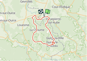
12,3 km | 15,2 km-effort
3h 27min
Ja


Sluiten
Mijn abonnementen