![](/images/other/stat-length.png)
![Tocht Stappen La Frette-sur-Seine - Bac La Frette - BAC Herblay - Photo](https://media.geolcdn.com/t/1900/400/ext.pjpeg?maxdim=2&url=https%3A%2F%2Fstatic1.geolcdn.com%2Fsiteimages%2Fupload%2Ffiles%2F1553511878bg_sport_marche.png)
Bac La Frette - BAC Herblay
N1N1Bernard
Gebruiker
![Lengte](/images/other/stat-length.png)
Lengte
10,9 km
![Max. hoogte](https://static1.geolcdn.com/siteimages/upload/files/1508320355ic_sort_altitude_max_24dp.png)
Max. hoogte
75 m
![Positief hoogteverschil](https://static1.geolcdn.com/siteimages/upload/files/1508320355ic_sort_den_pos_24dp.png)
Positief hoogteverschil
107 m
![Km-Effort](/images/other/stat-length.png)
Km-Effort
12,3 km
![Min. hoogte](https://static1.geolcdn.com/siteimages/upload/files/1508320355ic_sort_altitude_min_24dp.png)
Min. hoogte
16 m
![Negatief hoogteverschil](https://static1.geolcdn.com/siteimages/upload/files/1508320355ic_sort_den_neg_24dp.png)
Negatief hoogteverschil
100 m
![Boucle](https://static1.geolcdn.com/siteimages/upload/files/16400158638029165_repeat_loop_refresh_sync_direction_icon.png)
Boucle
Ja
Datum van aanmaak :
2021-07-11 09:25:20.0
Laatste wijziging :
2021-07-11 12:23:46.356
![Stappen](https://static1.geolcdn.com/sitytour/trail-icons/101.png)
2h57
Moeilijkheid : Gemakkelijk
![Scan deze QR-code om de tocht te openen in de SityTrail-applicatie](https://capi.geolives.com/qq0zvz2zws4bq2lad0pu/sitytour/trails/2857130/qr.png?size=200)
Gratisgps-wandelapplicatie
Over ons
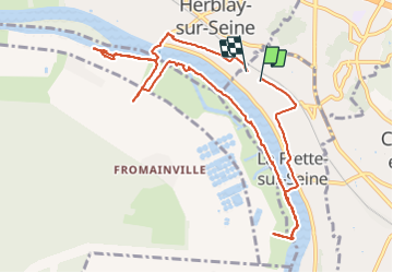
Tocht Stappen van 10,9 km beschikbaar op Île-de-France, Val-d'Oise, La Frette-sur-Seine. Deze tocht wordt voorgesteld door N1N1Bernard.
Beschrijving
Viaduc la Frette - Rue de la Gare - Église - Bac la Frette - Seine rive gauche - sculpture les miroir - Arborétum -Bac Herblay - église Herblay - GR
Plaatsbepaling
Land:
France
Regio :
Île-de-France
Departement/Provincie :
Val-d'Oise
Gemeente :
La Frette-sur-Seine
Locatie:
Unknown
Vertrek:(Dec)
Vertrek:(UTM)
439500 ; 5425897 (31U) N.
Opmerkingen
Wandeltochten in de omgeving
![Tocht Mountainbike Taverny - La Tabernacienne 2013 - Taverny - Photo](https://media.geolcdn.com/t/375/260/ext.jpg?maxdim=2&url=https%3A%2F%2Fservices.sitytrail.com%2FGeolivesWS%2FDownloadMedia.ashx%3FTrailID%3D191578%26Media%3D15203_6.jpg)
![Mountainbike Mountainbike](https://static1.geolcdn.com/sitytour/trail-icons/202.png)
La Tabernacienne 2013 - Taverny
Mountainbike
Medium
(1)
Taverny,
Île-de-France,
Val-d'Oise,
France
![](/images/other/stat-length.png)
32 km | 39 km-effort
2h 30min
![](https://static1.geolcdn.com/siteimages/upload/files/16400158638029165_repeat_loop_refresh_sync_direction_icon.png)
Ja
![Tocht Stappen Taverny - Boucle en forêt à partir de Taverny - Photo](https://media.geolcdn.com/t/375/260/ext.jpg?maxdim=2&url=https%3A%2F%2Fservices.sitytrail.com%2FGeolivesWS%2FDownloadMedia.ashx%3FTrailID%3D106699%26Media%3D11336_3.jpg)
![Stappen Stappen](https://static1.geolcdn.com/sitytour/trail-icons/101.png)
Boucle en forêt à partir de Taverny
Stappen
Medium
(1)
Taverny,
Île-de-France,
Val-d'Oise,
France
![](/images/other/stat-length.png)
12,3 km | 15,8 km-effort
3h 30min
![](https://static1.geolcdn.com/siteimages/upload/files/16400158638029165_repeat_loop_refresh_sync_direction_icon.png)
Ja
![Tocht Stappen Maisons-Laffitte - Forêt de Saint Germain en Laye - Photo](https://media.geolcdn.com/t/375/260/ext.jpg?maxdim=2&url=https%3A%2F%2Fservices.sitytrail.com%2FGeolivesWS%2FDownloadMedia.ashx%3FTrailID%3D110160%26Media%3D5360_1.jpg)
![Stappen Stappen](https://static1.geolcdn.com/sitytour/trail-icons/101.png)
Forêt de Saint Germain en Laye
Stappen
Moeilijk
(2)
Maisons-Laffitte,
Île-de-France,
Yvelines,
France
![](/images/other/stat-length.png)
22 km | 25 km-effort
4h 30min
![](https://static1.geolcdn.com/siteimages/upload/files/16400158638029165_repeat_loop_refresh_sync_direction_icon.png)
Ja
![Tocht Stappen Saint-Germain-en-Laye - MBE 5 km le mesnil route des portes - Photo](https://media.geolcdn.com/t/375/260/ext.jpg?maxdim=2&url=https%3A%2F%2Fstatic1.geolcdn.com%2Fsiteimages%2Fupload%2Ffiles%2F1553511878bg_sport_marche.png)
![Stappen Stappen](https://static1.geolcdn.com/sitytour/trail-icons/101.png)
MBE 5 km le mesnil route des portes
Stappen
Gemakkelijk
(1)
Saint-Germain-en-Laye,
Île-de-France,
Yvelines,
France
![](/images/other/stat-length.png)
4,8 km | 5,3 km-effort
1h 11min
![](https://static1.geolcdn.com/siteimages/upload/files/16400158638029165_repeat_loop_refresh_sync_direction_icon.png)
Ja
![Tocht Stappen Maisons-Laffitte - 20220909 RS - Photo](https://media.geolcdn.com/t/375/260/ext.jpg?maxdim=2&url=https%3A%2F%2Fstatic1.geolcdn.com%2Fsiteimages%2Fupload%2Ffiles%2F1553511878bg_sport_marche.png)
![Stappen Stappen](https://static1.geolcdn.com/sitytour/trail-icons/101.png)
20220909 RS
Stappen
Medium
(1)
Maisons-Laffitte,
Île-de-France,
Yvelines,
France
![](/images/other/stat-length.png)
5,7 km | 6,4 km-effort
1h 26min
![](https://static1.geolcdn.com/siteimages/upload/files/16400158638029165_repeat_loop_refresh_sync_direction_icon.png)
Ja
![Tocht Stappen Saint-Germain-en-Laye - 20220220 Petite boucle en forêt de Sy Germain - Photo](https://media.geolcdn.com/t/375/260/ext.jpg?maxdim=2&url=https%3A%2F%2Fstatic1.geolcdn.com%2Fsiteimages%2Fupload%2Ffiles%2F1553511878bg_sport_marche.png)
![Stappen Stappen](https://static1.geolcdn.com/sitytour/trail-icons/101.png)
20220220 Petite boucle en forêt de Sy Germain
Stappen
Gemakkelijk
(1)
Saint-Germain-en-Laye,
Île-de-France,
Yvelines,
France
![](/images/other/stat-length.png)
8,2 km | 9,2 km-effort
50min
![](https://static1.geolcdn.com/siteimages/upload/files/16400158638029165_repeat_loop_refresh_sync_direction_icon.png)
Ja
![Tocht Stappen Saint-Germain-en-Laye - Circuit MA 151219 - Photo](https://media.geolcdn.com/t/375/260/569e8f34-02aa-4776-807c-cdcab1bc2616.jpg&format=jpg&maxdim=2)
![Stappen Stappen](https://static1.geolcdn.com/sitytour/trail-icons/101.png)
Circuit MA 151219
Stappen
Heel gemakkelijk
(1)
Saint-Germain-en-Laye,
Île-de-France,
Yvelines,
France
![](/images/other/stat-length.png)
6,7 km | 7,5 km-effort
1h 26min
![](https://static1.geolcdn.com/siteimages/upload/files/16400158638029165_repeat_loop_refresh_sync_direction_icon.png)
Ja
![Tocht Noords wandelen Saint-Germain-en-Laye - SityTrail - MN CDN 14 KM MARE AUX CANES - Photo](https://media.geolcdn.com/t/375/260/ext.jpg?maxdim=2&url=https%3A%2F%2Fstatic1.geolcdn.com%2Fsiteimages%2Fupload%2Ffiles%2F1545311037marcheuse_200dpi.jpg)
![Noords wandelen Noords wandelen](https://static1.geolcdn.com/sitytour/trail-icons/102.png)
SityTrail - MN CDN 14 KM MARE AUX CANES
Noords wandelen
Heel gemakkelijk
(1)
Saint-Germain-en-Laye,
Île-de-France,
Yvelines,
France
![](/images/other/stat-length.png)
13,9 km | 15,6 km-effort
2h 0min
![](https://static1.geolcdn.com/siteimages/upload/files/16400158638029165_repeat_loop_refresh_sync_direction_icon.png)
Neen
![Tocht Andere activiteiten Maisons-Laffitte - maison Laffitte - Photo](https://media.geolcdn.com/t/375/260/ext.jpg?maxdim=2&url=https%3A%2F%2Fstatic1.geolcdn.com%2Fsiteimages%2Fupload%2Ffiles%2F1545311037marcheuse_200dpi.jpg)
![Andere activiteiten Andere activiteiten](https://static1.geolcdn.com/sitytour/trail-icons/900.png)
maison Laffitte
Andere activiteiten
Medium
(2)
Maisons-Laffitte,
Île-de-France,
Yvelines,
France
![](/images/other/stat-length.png)
24 km | 27 km-effort
6h 54min
![](https://static1.geolcdn.com/siteimages/upload/files/16400158638029165_repeat_loop_refresh_sync_direction_icon.png)
Ja