![](/images/other/stat-length.png)
![Tocht Stappen Courmayeur - TMB 06 - Arnouva -> La Fouly - Photo](https://media.geolcdn.com/t/1900/400/ext.pjpeg?maxdim=2&url=https%3A%2F%2Fstatic1.geolcdn.com%2Fsiteimages%2Fupload%2Ffiles%2F1553511878bg_sport_marche.png)
TMB 06 - Arnouva -> La Fouly
uru2010
Gebruiker
![Lengte](/images/other/stat-length.png)
Lengte
15,4 km
![Max. hoogte](https://static1.geolcdn.com/siteimages/upload/files/1508320355ic_sort_altitude_max_24dp.png)
Max. hoogte
2537 m
![Positief hoogteverschil](https://static1.geolcdn.com/siteimages/upload/files/1508320355ic_sort_den_pos_24dp.png)
Positief hoogteverschil
784 m
![Km-Effort](/images/other/stat-length.png)
Km-Effort
26 km
![Min. hoogte](https://static1.geolcdn.com/siteimages/upload/files/1508320355ic_sort_altitude_min_24dp.png)
Min. hoogte
1601 m
![Negatief hoogteverschil](https://static1.geolcdn.com/siteimages/upload/files/1508320355ic_sort_den_neg_24dp.png)
Negatief hoogteverschil
953 m
![Boucle](https://static1.geolcdn.com/siteimages/upload/files/16400158638029165_repeat_loop_refresh_sync_direction_icon.png)
Boucle
Neen
Datum van aanmaak :
2021-06-28 06:15:50.779
Laatste wijziging :
2022-05-08 14:41:50.216
![Stappen](https://static1.geolcdn.com/sitytour/trail-icons/101.png)
6h19
Moeilijkheid : Moeilijk
![Scan deze QR-code om de tocht te openen in de SityTrail-applicatie](https://capi.geolives.com/qq0zvz2zws4bq2lad0pu/sitytour/trails/2843090/qr.png?size=200)
Gratisgps-wandelapplicatie
Over ons
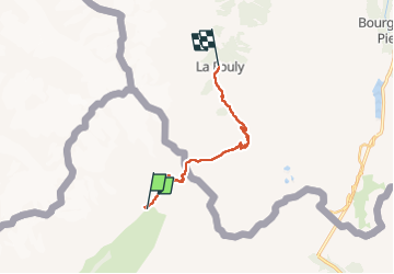
Tocht Stappen van 15,4 km beschikbaar op Valle d'Aosta, Onbekend, Courmayeur. Deze tocht wordt voorgesteld door uru2010.
Beschrijving
Départ : Chalet Val Ferret, Arnouva (Italie)
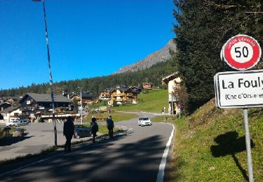
Arrivée : Hôtel Edelweiss, 44 route de Ferret, La Fouly (Suisse). Tél : 41 27 783 26 21.
Randonnée faite le 28/6/2021.
Durée suivant le guide : 5h50. Ma durée réelle : 6h20.
Plaatsbepaling
Land:
Italy
Regio :
Valle d'Aosta
Departement/Provincie :
Onbekend
Gemeente :
Courmayeur
Locatie:
Unknown
Vertrek:(Dec)
Vertrek:(UTM)
348928 ; 5081574 (32T) N.
Opmerkingen
Wandeltochten in de omgeving
![Tocht Te voet Saint-Rhémy-en-Bosses - Alta Via n. 1 della Valle d'Aosta - Tappa 16 - Photo](https://media.geolcdn.com/t/375/260/ext.jpg?maxdim=2&url=https%3A%2F%2Fmedia.geolcdn.com%2Ff%2Fc1ffe823-e45b-4285-b419-885b4a3183dc.jpeg)
![Te voet Te voet](https://static1.geolcdn.com/sitytour/trail-icons/100.png)
Alta Via n. 1 della Valle d'Aosta - Tappa 16
Te voet
Gemakkelijk
Saint-Rhémy-en-Bosses,
Valle d'Aosta,
Onbekend,
Italy
![](/images/other/stat-length.png)
7,5 km | 14,5 km-effort
3h 17min
![](https://static1.geolcdn.com/siteimages/upload/files/16400158638029165_repeat_loop_refresh_sync_direction_icon.png)
Neen
![Tocht Te voet Courmayeur - Alta Via n. 1 della Valle d'Aosta - Tappa 17 - Photo](https://media.geolcdn.com/t/375/260/ext.jpg?maxdim=2&url=https%3A%2F%2Fmedia.geolcdn.com%2Ff%2Fc06bc34d-6b1f-4048-adf9-d9a66a4e497f.jpeg)
![Te voet Te voet](https://static1.geolcdn.com/sitytour/trail-icons/100.png)
Alta Via n. 1 della Valle d'Aosta - Tappa 17
Te voet
Gemakkelijk
Courmayeur,
Valle d'Aosta,
Onbekend,
Italy
![](/images/other/stat-length.png)
11,9 km | 18,2 km-effort
4h 8min
![](https://static1.geolcdn.com/siteimages/upload/files/16400158638029165_repeat_loop_refresh_sync_direction_icon.png)
Neen
![Tocht Te voet Saint-Rhémy-en-Bosses - (SI F10 Rifugio Frassati - Saint-Rhémy - Photo](https://media.geolcdn.com/t/375/260/ext.jpg?maxdim=2&url=https%3A%2F%2Fmedia.geolcdn.com%2Ff%2Fb0f4c857-e2a4-45eb-acab-68951156d996.jpeg)
![Te voet Te voet](https://static1.geolcdn.com/sitytour/trail-icons/100.png)
(SI F10 Rifugio Frassati - Saint-Rhémy
Te voet
Gemakkelijk
Saint-Rhémy-en-Bosses,
Valle d'Aosta,
Onbekend,
Italy
![](/images/other/stat-length.png)
10,4 km | 14,7 km-effort
3h 20min
![](https://static1.geolcdn.com/siteimages/upload/files/16400158638029165_repeat_loop_refresh_sync_direction_icon.png)
Neen
![Tocht Te voet Courmayeur - (SI F09) Rifugio Bonatti - Rifugio Frassati - Photo](https://media.geolcdn.com/t/375/260/ext.jpg?maxdim=2&url=https%3A%2F%2Fmedia.geolcdn.com%2Ff%2Fc1ffe823-e45b-4285-b419-885b4a3183dc.jpeg)
![Te voet Te voet](https://static1.geolcdn.com/sitytour/trail-icons/100.png)
(SI F09) Rifugio Bonatti - Rifugio Frassati
Te voet
Gemakkelijk
Courmayeur,
Valle d'Aosta,
Onbekend,
Italy
![](/images/other/stat-length.png)
7,5 km | 17,6 km-effort
4h 0min
![](https://static1.geolcdn.com/siteimages/upload/files/16400158638029165_repeat_loop_refresh_sync_direction_icon.png)
Neen
![Tocht Te voet Courmayeur - Itinerario 23 Rifugio Dalmazzi - Photo](https://media.geolcdn.com/t/375/260/ext.jpg?maxdim=2&url=https%3A%2F%2Fmedia.geolcdn.com%2Ff%2F2530e1b3-3a61-40c9-a091-23aae0135330.jpeg)
![Te voet Te voet](https://static1.geolcdn.com/sitytour/trail-icons/100.png)
Itinerario 23 Rifugio Dalmazzi
Te voet
Gemakkelijk
Courmayeur,
Valle d'Aosta,
Onbekend,
Italy
![](/images/other/stat-length.png)
4,1 km | 6,6 km-effort
1h 29min
![](https://static1.geolcdn.com/siteimages/upload/files/16400158638029165_repeat_loop_refresh_sync_direction_icon.png)
Neen
![Tocht Stappen Courmayeur - TMB J4 Ref.ELENA - COURMAYEUR - Photo](https://media.geolcdn.com/t/375/260/ext.jpg?maxdim=2&url=https%3A%2F%2Fservices.sitytrail.com%2FGeolivesWS%2FDownloadMedia.ashx%3FTrailID%3D594957%26Media%3Dfix__20160706110719.jpg)
![Stappen Stappen](https://static1.geolcdn.com/sitytour/trail-icons/101.png)
TMB J4 Ref.ELENA - COURMAYEUR
Stappen
Medium
Courmayeur,
Valle d'Aosta,
Onbekend,
Italy
![](/images/other/stat-length.png)
13,5 km | 22 km-effort
4h 18min
![](https://static1.geolcdn.com/siteimages/upload/files/16400158638029165_repeat_loop_refresh_sync_direction_icon.png)
Neen
![Tocht Stappen Courmayeur - TMB day 4 - Photo](https://media.geolcdn.com/t/375/260/ext.jpg?maxdim=2&url=https%3A%2F%2Fservices.sitytrail.com%2FGeolivesWS%2FDownloadMedia.ashx%3FTrailID%3D477599%26Media%3Dfix__20150924164207.jpg)
![Stappen Stappen](https://static1.geolcdn.com/sitytour/trail-icons/101.png)
TMB day 4
Stappen
Medium
Courmayeur,
Valle d'Aosta,
Onbekend,
Italy
![](/images/other/stat-length.png)
16,6 km | 27 km-effort
5h 37min
![](https://static1.geolcdn.com/siteimages/upload/files/16400158638029165_repeat_loop_refresh_sync_direction_icon.png)
Neen
![Tocht Stappen Courmayeur - TMB6 AN - Photo](https://media.geolcdn.com/t/375/260/ext.jpg?maxdim=2&url=https%3A%2F%2Fmedia.geolcdn.com%2Ff%2Fc508a572-a524-441c-8f7e-e7526a957179.jpg)
![Stappen Stappen](https://static1.geolcdn.com/sitytour/trail-icons/101.png)
TMB6 AN
Stappen
Gemakkelijk
Courmayeur,
Valle d'Aosta,
Onbekend,
Italy
![](/images/other/stat-length.png)
12,6 km | 21 km-effort
4h 5min
![](https://static1.geolcdn.com/siteimages/upload/files/16400158638029165_repeat_loop_refresh_sync_direction_icon.png)
Neen
![Tocht Stappen Courmayeur - tmb2024 étape 5 - Photo](https://media.geolcdn.com/t/375/260/ext.jpg?maxdim=2&url=https%3A%2F%2Fmedia.geolcdn.com%2Ff%2Fe2a0dabe-4853-468a-a72d-cc4ec796e137.jpg)
![Stappen Stappen](https://static1.geolcdn.com/sitytour/trail-icons/101.png)
tmb2024 étape 5
Stappen
Medium
Courmayeur,
Valle d'Aosta,
Onbekend,
Italy
![](/images/other/stat-length.png)
20 km | 34 km-effort
9h 18min
![](https://static1.geolcdn.com/siteimages/upload/files/16400158638029165_repeat_loop_refresh_sync_direction_icon.png)
Neen