Tocht Te voet Pont-d'Ouilly - Pont d'ouilly chemin du Roy - Photo

Pont d'ouilly chemin du Roy

 lepompi
lepompi

Gebruiker

© OpenStreetMap contributors
Lengte
Lengte
9,9 km
Max. hoogte
Max. hoogte
207 m
Positief hoogteverschil
288 m
Km-Effort
Km-Effort  
13,8 km
Min. hoogte
Min. hoogte
72 m
Negatief hoogteverschil
293 m
Boucle
Boucle
Ja
Datum van aanmaak :
2021-06-24 14:42:23.143
Laatste wijziging :
2021-06-24 14:46:27.464

(0 Bericht)

Te voet
Te voet
3h08
Moeilijkheid : Gemakkelijk

Scan deze QR-code om de tocht te openen in de SityTrail-applicatie

Gratisgps-wandelapplicatie

Logo SityTrail SityTrail

IGN / Geografische instituten

SityTrail uit de App Store downloaden SityTrail uit Google Play downloaden

Logo SityTrail SityTrail World

De wereld gaat voor u open

SityTrail uit de App Store downloaden SityTrail uit Google Play downloaden SityTrail op Huawei AppGallery downloaden

Over ons

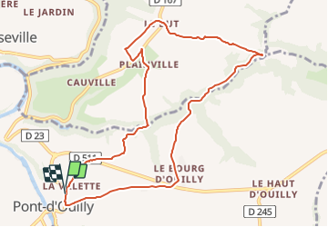
Tocht Te voet van 9,9 km beschikbaar op Normandië, Calvados, Pont-d'Ouilly. Deze tocht wordt voorgesteld door lepompi.

Beschrijving

D'apres le tracé de Magny que j,ai corrigé

Sympa ,routes tres peu fréquentées !
bonne partie sur chemins

Hoogteprofiel

Plaatsbepaling

Land:
France
Regio :
Normandië
Departement/Provincie :
Calvados
Gemeente :
Pont-d'Ouilly
Locatie:
Unknown
Vertrek:(UTM)
690093 ; 5416957 (30U) N.

Wandeltochten in de omgeving

Tocht Mountainbike Pont-d'Ouilly - La Petite Suisse Normande 2014 - Pont-d'Ouilly - Photo
Mountainbike
tracegps

Mountainbike

Moeilijk
(1)
Pont-d'Ouilly, Normandië, Calvados, France
41 km | 54 km-effort
3h 30min
Ja
Tocht Stappen Le Vey - Clécy - Photo
Stappen
zefreefly

Stappen

Gemakkelijk
(1)
Le Vey, Normandië, Calvados, France
14,8 km | 20 km-effort
3h 51min
Ja
Tocht Stappen Ménil-Hubert-sur-Orne - De Rouvroy aux Roches d'Oetre par le sentier des Méandres  - Photo
Stappen
Ecureuiltrailer

Stappen

Medium
Ménil-Hubert-sur-Orne, Normandië, Orne, France
7,1 km | 9,3 km-effort
2h 1min
Ja
Tocht Te voet Saint-Philbert-sur-Orne - Entre Orne et Rouvre - Photo
Te voet
PRO

Te voet

Gemakkelijk
Saint-Philbert-sur-Orne, Normandië, Orne, France
7,7 km | 10,3 km-effort
2h 19min
Ja
Tocht Te voet Pont-d'Ouilly - Circuit du Val la Hère - Photo
Te voet
PRO

Te voet

Gemakkelijk
Pont-d'Ouilly, Normandië, Calvados, France
6,7 km | 9,4 km-effort
2h 7min
Ja
Tocht Te voet Le Bô - Des Montagnes de Normandie? - Photo
Te voet
PRO

Te voet

Medium
Le Bô, Normandië, Calvados, France
15,4 km | 20 km-effort
4h 38min
Neen
Tocht Te voet La Pommeraye - Les Rochers de Briesvieille - Photo
Te voet
PRO

Te voet

Gemakkelijk
La Pommeraye, Normandië, Calvados, France
9,1 km | 12,9 km-effort
2h 55min
Neen
Tocht Te voet Le Bô - Le Moulin à Papier - Photo
Te voet
PRO

Te voet

Gemakkelijk
Le Bô, Normandië, Calvados, France
7,1 km | 9,6 km-effort
2h 11min
Ja
Tocht Te voet Le Mesnil-Villement - Tour du Pays de Falaise - Photo
Te voet
PRO

Te voet

Gemakkelijk
Le Mesnil-Villement, Normandië, Calvados, France
8,6 km | 11,9 km-effort
2h 42min
Neen


Sluiten
Mijn abonnementen