Tocht Stappen Montesquieu-des-Albères - Collioure Montesquieu les Albères - Photo
 Delahalle
Delahalle

Gebruiker

© OpenStreetMap contributors
Lengte
Lengte
6,5 km
Max. hoogte
Max. hoogte
360 m
Positief hoogteverschil
214 m
Km-Effort
Km-Effort  
9,4 km
Min. hoogte
Min. hoogte
156 m
Negatief hoogteverschil
215 m
Boucle
Boucle
Ja
Datum van aanmaak :
2021-06-24 07:48:47.701
Laatste wijziging :
2021-06-24 16:35:57.059

(0 Bericht)

Stappen
Stappen
2h10
Moeilijkheid : Gemakkelijk

Scan deze QR-code om de tocht te openen in de SityTrail-applicatie

Gratisgps-wandelapplicatie

Logo SityTrail SityTrail

IGN / Geografische instituten

SityTrail uit de App Store downloaden SityTrail uit Google Play downloaden

Logo SityTrail SityTrail World

De wereld gaat voor u open

SityTrail uit de App Store downloaden SityTrail uit Google Play downloaden SityTrail op Huawei AppGallery downloaden

Over ons

Tocht Stappen van 6,5 km beschikbaar op Occitanië, Pyrénées-Orientales, Montesquieu-des-Albères. Deze tocht wordt voorgesteld door Delahalle.

Beschrijving

Randonnée facile avec une partie panoramique et sur la fin un sentier botanique et sur les oiseaux pour terminer avec une petite visite du centre du village (château).

Hoogteprofiel

Foto's

Plaatsbepaling

Land:
France
Regio :
Occitanië
Departement/Provincie :
Pyrénées-Orientales
Gemeente :
Montesquieu-des-Albères
Locatie:
Unknown
Vertrek:(UTM)
490153 ; 4707261 (31T) N.

Wandeltochten in de omgeving

Tocht Stappen Les Cluses - LES CLUSES 66 - Photo
Stappen
jeff66

Stappen

Gemakkelijk
(9)
Les Cluses, Occitanië, Pyrénées-Orientales, France
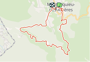
9,4 km | 12,8 km-effort
1h 50min
Ja
Tocht Stappen Laroque-des-Albères - Laroque-des-Albères, petit tour des mas  - Photo
Stappen
GUIDE
stef789

Stappen

Heel gemakkelijk
(1)
Laroque-des-Albères, Occitanië, Pyrénées-Orientales, France
5,4 km | 7,1 km-effort
1h 47min
Ja
Tocht Stappen Laroque-des-Albères - 66 LAROQUE DES ALBERES (maison) SOREDE, par pistes DFCI AL12 et 19, mas del Ca et mas Manere, Itin.16  - Photo
Stappen
jeff66

Stappen

Medium
(1)
Laroque-des-Albères, Occitanië, Pyrénées-Orientales, France
11,2 km | 15,3 km-effort
2h 5min
Ja
Tocht Stappen L'Albère - SAINT-JEAN-D'ALBERE 66 - PUIG  de Sant Christau par le coll de Sant Joan  - Photo
Stappen
jeff66

Stappen

Moeilijk
(1)
L'Albère, Occitanië, Pyrénées-Orientales, France
10,1 km | 17 km-effort
2h 46min
Ja
Tocht Stappen Montesquieu-des-Albères - MONTESQUIEU-DES-ALBERES 66 - Les Agouillous - les chemins de l'eau dans les Albères - Photo
Stappen
jeff66

Stappen

Medium
(1)
Montesquieu-des-Albères, Occitanië, Pyrénées-Orientales, France
12,7 km | 13,9 km-effort
2h 16min
Ja
Tocht Stappen Le Boulou - LES THERMES DU BOULOU - 66 - Albera viva - PUIG de l'Estella - Photo
Stappen
jeff66

Stappen

Medium
(2)
Le Boulou, Occitanië, Pyrénées-Orientales, France
7,3 km | 11,4 km-effort
1h 32min
Ja
Tocht Stappen Laroque-des-Albères - Col-Ullat Pic-aureille_Terrain - Photo
Stappen
force

Stappen

Medium
(1)
Laroque-des-Albères, Occitanië, Pyrénées-Orientales, France
11,2 km | 23 km-effort
4h 47min
Ja
Tocht Stappen Laroque-des-Albères - laroque . four solaire . sorede . laroque - Photo
Stappen
GUIDE
stef789

Stappen

Medium
Laroque-des-Albères, Occitanië, Pyrénées-Orientales, France
7,7 km | 9,2 km-effort
1h 57min
Ja
Tocht Hybride fiets Le Boulou - Autour du Boulou (66) - Photo
Hybride fiets
GUIDE
toutankhcarton

Hybride fiets

Gemakkelijk
Le Boulou, Occitanië, Pyrénées-Orientales, France
17 km | 19,5 km-effort
1h 54min
Neen


Sluiten
Mijn abonnementen