![](/images/other/stat-length.png)
![Tocht Stappen Fougères - GR_37_AF_20_Fougeres_Chapelle-Janson_20210619 - Photo](https://media.geolcdn.com/t/1900/400/e8e1e45f-0996-4dce-a377-c3d0b42607e7.jpg&format=pjpeg&maxdim=2)
GR_37_AF_20_Fougeres_Chapelle-Janson_20210619
patrickdanilo
Gebruiker
![Lengte](/images/other/stat-length.png)
Lengte
9,9 km
![Max. hoogte](https://static1.geolcdn.com/siteimages/upload/files/1508320355ic_sort_altitude_max_24dp.png)
Max. hoogte
185 m
![Positief hoogteverschil](https://static1.geolcdn.com/siteimages/upload/files/1508320355ic_sort_den_pos_24dp.png)
Positief hoogteverschil
197 m
![Km-Effort](/images/other/stat-length.png)
Km-Effort
12,5 km
![Min. hoogte](https://static1.geolcdn.com/siteimages/upload/files/1508320355ic_sort_altitude_min_24dp.png)
Min. hoogte
106 m
![Negatief hoogteverschil](https://static1.geolcdn.com/siteimages/upload/files/1508320355ic_sort_den_neg_24dp.png)
Negatief hoogteverschil
196 m
![Boucle](https://static1.geolcdn.com/siteimages/upload/files/16400158638029165_repeat_loop_refresh_sync_direction_icon.png)
Boucle
Neen
Datum van aanmaak :
2021-06-19 07:18:08.178
Laatste wijziging :
2022-02-09 13:49:09.06
![Stappen](https://static1.geolcdn.com/sitytour/trail-icons/101.png)
2h28
Moeilijkheid : Gemakkelijk
![Scan deze QR-code om de tocht te openen in de SityTrail-applicatie](https://capi.geolives.com/qq0zvz2zws4bq2lad0pu/sitytour/trails/2831888/qr.png?size=200)
Gratisgps-wandelapplicatie
Over ons
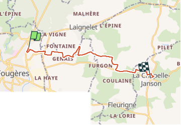
Tocht Stappen van 9,9 km beschikbaar op Bretagne, Ille-et-Vilaine, Fougères. Deze tocht wordt voorgesteld door patrickdanilo.
Beschrijving
GR®37
Cœur de la Bretagne
Du Mont-Saint-Michel (Manche) Normandie
à Camaret-sur-Mer (Finistère) Bretagne
780km
Plaatsbepaling
Land:
France
Regio :
Bretagne
Departement/Provincie :
Ille-et-Vilaine
Gemeente :
Fougères
Locatie:
Unknown
Vertrek:(Dec)
Vertrek:(UTM)
634439 ; 5358149 (30U) N.
Opmerkingen
Wandeltochten in de omgeving
![Tocht Te voet Landéan - Les Vieux Châteaux - Photo](https://media.geolcdn.com/t/375/260/122c427c-456b-4f47-979b-0a8d83dc03ab.jpeg&format=jpg&maxdim=2)
![Te voet Te voet](https://static1.geolcdn.com/sitytour/trail-icons/100.png)
Les Vieux Châteaux
Te voet
Gemakkelijk
(1)
Landéan,
Bretagne,
Ille-et-Vilaine,
France
![](/images/other/stat-length.png)
5,3 km | 6,3 km-effort
1h 26min
![](https://static1.geolcdn.com/siteimages/upload/files/16400158638029165_repeat_loop_refresh_sync_direction_icon.png)
Ja
![Tocht Te voet Landéan - La Longue Noë - Photo](https://media.geolcdn.com/t/375/260/f327ed77-355c-4519-bce4-a684f55ad906.jpeg&format=jpg&maxdim=2)
![Te voet Te voet](https://static1.geolcdn.com/sitytour/trail-icons/100.png)
La Longue Noë
Te voet
Gemakkelijk
Landéan,
Bretagne,
Ille-et-Vilaine,
France
![](/images/other/stat-length.png)
6,2 km | 7,4 km-effort
1h 41min
![](https://static1.geolcdn.com/siteimages/upload/files/16400158638029165_repeat_loop_refresh_sync_direction_icon.png)
Ja
![Tocht Noords wandelen Landéan - Poulailler autour du Moulin d'Avion 12,5km - Photo](https://media.geolcdn.com/t/375/260/ext.jpg?maxdim=2&url=https%3A%2F%2Fservices.sitytrail.com%2FGeolivesWS%2FDownloadMedia.ashx%3FTrailID%3D676451%26Media%3Dcc3eee66-6e8e-4acd-8735-e9a30f06fcf1.jpeg)
![Noords wandelen Noords wandelen](https://static1.geolcdn.com/sitytour/trail-icons/102.png)
Poulailler autour du Moulin d'Avion 12,5km
Noords wandelen
Medium
Landéan,
Bretagne,
Ille-et-Vilaine,
France
![](/images/other/stat-length.png)
12,5 km | 14,9 km-effort
2h 10min
![](https://static1.geolcdn.com/siteimages/upload/files/16400158638029165_repeat_loop_refresh_sync_direction_icon.png)
Ja
![Tocht Noords wandelen Landéan - Poulailler Chénedet 10,4km - Photo](https://media.geolcdn.com/t/375/260/ext.jpg?maxdim=2&url=https%3A%2F%2Fservices.sitytrail.com%2FGeolivesWS%2FDownloadMedia.ashx%3FTrailID%3D676433%26Media%3Dc418e412-7874-4576-9726-02eef27b2c32.jpg)
![Noords wandelen Noords wandelen](https://static1.geolcdn.com/sitytour/trail-icons/102.png)
Poulailler Chénedet 10,4km
Noords wandelen
Medium
Landéan,
Bretagne,
Ille-et-Vilaine,
France
![](/images/other/stat-length.png)
10,3 km | 12,5 km-effort
2h 50min
![](https://static1.geolcdn.com/siteimages/upload/files/16400158638029165_repeat_loop_refresh_sync_direction_icon.png)
Ja
![Tocht Noords wandelen Landéan - CMN Albert 10km - Photo](https://media.geolcdn.com/t/375/260/ext.jpg?maxdim=2&url=https%3A%2F%2Fservices.sitytrail.com%2FGeolivesWS%2FDownloadMedia.ashx%3FTrailID%3D189602%26Media%3D27502648-31d9-4ef3-b6ad-5dd7e3ce8752.jpg)
![Noords wandelen Noords wandelen](https://static1.geolcdn.com/sitytour/trail-icons/102.png)
CMN Albert 10km
Noords wandelen
Medium
Landéan,
Bretagne,
Ille-et-Vilaine,
France
![](/images/other/stat-length.png)
9,9 km | 12 km-effort
1h 40min
![](https://static1.geolcdn.com/siteimages/upload/files/16400158638029165_repeat_loop_refresh_sync_direction_icon.png)
Ja
![Tocht Noords wandelen Landéan - CMN Françoise 10 - Photo](https://media.geolcdn.com/t/375/260/ext.jpg?maxdim=2&url=https%3A%2F%2Fservices.sitytrail.com%2FGeolivesWS%2FDownloadMedia.ashx%3FTrailID%3D188449%26Media%3D09b0d8a3-5ae2-461c-ad1f-fb0e22cf207f.jpg)
![Noords wandelen Noords wandelen](https://static1.geolcdn.com/sitytour/trail-icons/102.png)
CMN Françoise 10
Noords wandelen
Medium
Landéan,
Bretagne,
Ille-et-Vilaine,
France
![](/images/other/stat-length.png)
10,5 km | 12,5 km-effort
1h 50min
![](https://static1.geolcdn.com/siteimages/upload/files/16400158638029165_repeat_loop_refresh_sync_direction_icon.png)
Ja
![Tocht Noords wandelen Landéan - Léandre - Photo](https://media.geolcdn.com/t/375/260/ext.jpg?maxdim=2&url=https%3A%2F%2Fservices.sitytrail.com%2FGeolivesWS%2FDownloadMedia.ashx%3FTrailID%3D187651%26Media%3D263e6600-ee89-4974-b42c-0cf56a92d847.jpg)
![Noords wandelen Noords wandelen](https://static1.geolcdn.com/sitytour/trail-icons/102.png)
Léandre
Noords wandelen
Medium
Landéan,
Bretagne,
Ille-et-Vilaine,
France
![](/images/other/stat-length.png)
12,4 km | 14,9 km-effort
2h 20min
![](https://static1.geolcdn.com/siteimages/upload/files/16400158638029165_repeat_loop_refresh_sync_direction_icon.png)
Ja
![Tocht Noords wandelen Landéan - CMN Du Poulailler dans la ville 15 km - Photo](https://media.geolcdn.com/t/375/260/ext.jpg?maxdim=2&url=https%3A%2F%2Fservices.sitytrail.com%2FGeolivesWS%2FDownloadMedia.ashx%3FTrailID%3D162112%26Media%3D9e9344dd-ab74-44da-9479-e497c8838235.jpeg)
![Noords wandelen Noords wandelen](https://static1.geolcdn.com/sitytour/trail-icons/102.png)
CMN Du Poulailler dans la ville 15 km
Noords wandelen
Medium
Landéan,
Bretagne,
Ille-et-Vilaine,
France
![](/images/other/stat-length.png)
14,9 km | 18 km-effort
2h 50min
![](https://static1.geolcdn.com/siteimages/upload/files/16400158638029165_repeat_loop_refresh_sync_direction_icon.png)
Ja
![Tocht Noords wandelen Landéan - Poulailler à Galoupel 11,6km - Photo](https://media.geolcdn.com/t/375/260/ext.jpg?maxdim=2&url=https%3A%2F%2Fservices.sitytrail.com%2FGeolivesWS%2FDownloadMedia.ashx%3FTrailID%3D162110%26Media%3D413a32e4-2e2a-44c9-a005-215b3d70b193.jpg)
![Noords wandelen Noords wandelen](https://static1.geolcdn.com/sitytour/trail-icons/102.png)
Poulailler à Galoupel 11,6km
Noords wandelen
Medium
Landéan,
Bretagne,
Ille-et-Vilaine,
France
![](/images/other/stat-length.png)
11,5 km | 13,9 km-effort
2h 10min
![](https://static1.geolcdn.com/siteimages/upload/files/16400158638029165_repeat_loop_refresh_sync_direction_icon.png)
Ja