![](/images/other/stat-length.png)
![Tocht Stappen Paliseul - MERNY-BOTASSART-SENSENRUTH-MOGIMONT-MERNY - Photo](https://media.geolcdn.com/t/1900/400/72792ccf-dd73-4bcf-bf3c-23bfff59fce5.jpg&format=pjpeg&maxdim=2)
MERNY-BOTASSART-SENSENRUTH-MOGIMONT-MERNY
JEANMINNE
Gebruiker
![Lengte](/images/other/stat-length.png)
Lengte
28 km
![Max. hoogte](https://static1.geolcdn.com/siteimages/upload/files/1508320355ic_sort_altitude_max_24dp.png)
Max. hoogte
450 m
![Positief hoogteverschil](https://static1.geolcdn.com/siteimages/upload/files/1508320355ic_sort_den_pos_24dp.png)
Positief hoogteverschil
549 m
![Km-Effort](/images/other/stat-length.png)
Km-Effort
35 km
![Min. hoogte](https://static1.geolcdn.com/siteimages/upload/files/1508320355ic_sort_altitude_min_24dp.png)
Min. hoogte
213 m
![Negatief hoogteverschil](https://static1.geolcdn.com/siteimages/upload/files/1508320355ic_sort_den_neg_24dp.png)
Negatief hoogteverschil
549 m
![Boucle](https://static1.geolcdn.com/siteimages/upload/files/16400158638029165_repeat_loop_refresh_sync_direction_icon.png)
Boucle
Ja
Datum van aanmaak :
2021-06-12 07:04:06.922
Laatste wijziging :
2021-06-12 18:40:25.811
![Stappen](https://static1.geolcdn.com/sitytour/trail-icons/101.png)
10h10
Moeilijkheid : Moeilijk
![Scan deze QR-code om de tocht te openen in de SityTrail-applicatie](https://capi.geolives.com/qq0zvz2zws4bq2lad0pu/sitytour/trails/2824552/qr.png?size=200)
Gratisgps-wandelapplicatie
Over ons
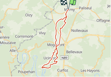
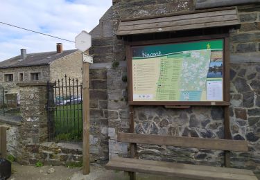
Tocht Stappen van 28 km beschikbaar op Wallonië, Luxemburg, Paliseul. Deze tocht wordt voorgesteld door JEANMINNE.
Beschrijving
Merny-Bois du Defoi-Les Versaines-Le Ratentout-Chevraifeche-La Justice-Gros Terne-Moulin du Rivage-Cul de Collin-Fond de Lavau -Sensenruth-Bovomoulin-Chateau le Duc-Mogimont-La Charité-Waillimont-La Rochette-Merny.
Plaatsbepaling
Land:
Belgium
Regio :
Wallonië
Departement/Provincie :
Luxemburg
Gemeente :
Paliseul
Locatie:
Unknown
Vertrek:(Dec)
Vertrek:(UTM)
650599 ; 5529866 (31U) N.
Opmerkingen
Wandeltochten in de omgeving
![Tocht Stappen Bouillon - RB-Lu-12 - Premier contact avec la Semois au Tombeau du Géant - Photo](https://media.geolcdn.com/t/375/260/ext.jpg?maxdim=2&url=https%3A%2F%2Fservices.sitytrail.com%2FGeolivesWS%2FDownloadMedia.ashx%3FTrailID%3D179617%26Media%3Dd1ff11f2-43fb-4a27-8679-182dbfec36f0.jpg)
![Stappen Stappen](https://static1.geolcdn.com/sitytour/trail-icons/101.png)
RB-Lu-12 - Premier contact avec la Semois au Tombeau du Géant
Stappen
Zeer moeilijk
(6)
Bouillon,
Wallonië,
Luxemburg,
Belgium
![](/images/other/stat-length.png)
19,1 km | 27 km-effort
6h 7min
![](https://static1.geolcdn.com/siteimages/upload/files/16400158638029165_repeat_loop_refresh_sync_direction_icon.png)
Ja
![Stappen Stappen](https://static1.geolcdn.com/sitytour/trail-icons/101.png)
RB-Lu-24 - Launoy - Via raccourci 1
Stappen
Zeer moeilijk
(1)
Paliseul,
Wallonië,
Luxemburg,
Belgium
![](/images/other/stat-length.png)
20 km | 26 km-effort
5h 52min
![](https://static1.geolcdn.com/siteimages/upload/files/16400158638029165_repeat_loop_refresh_sync_direction_icon.png)
Ja
![Tocht Stappen Paliseul - Marche ADEPS à Carlbourg. 9 km 200 - Photo](https://media.geolcdn.com/t/375/260/bea0c187-f0c2-4e7c-8aec-60125f26f246.jpg&format=jpg&maxdim=2)
![Stappen Stappen](https://static1.geolcdn.com/sitytour/trail-icons/101.png)
Marche ADEPS à Carlbourg. 9 km 200
Stappen
Medium
Paliseul,
Wallonië,
Luxemburg,
Belgium
![](/images/other/stat-length.png)
9,4 km | 12 km-effort
1h 56min
![](https://static1.geolcdn.com/siteimages/upload/files/16400158638029165_repeat_loop_refresh_sync_direction_icon.png)
Ja
![Tocht Stappen Bièvre - Marche ADEPS 10KM400 à Graide. - Photo](https://media.geolcdn.com/t/375/260/f5dfd78c-f060-4d8c-b9fd-b47c4cdcaa0b.jpg&format=jpg&maxdim=2)
![Stappen Stappen](https://static1.geolcdn.com/sitytour/trail-icons/101.png)
Marche ADEPS 10KM400 à Graide.
Stappen
Medium
Bièvre,
Wallonië,
Namen,
Belgium
![](/images/other/stat-length.png)
10,4 km | 13 km-effort
2h 12min
![](https://static1.geolcdn.com/siteimages/upload/files/16400158638029165_repeat_loop_refresh_sync_direction_icon.png)
Ja
![Tocht Stappen Paliseul - Marche ADEPS 10KM500 à Carlsbourg - Photo](https://media.geolcdn.com/t/375/260/68707cc8-4f4e-4044-881a-06d21ba7fd02.jpg&format=jpg&maxdim=2)
![Stappen Stappen](https://static1.geolcdn.com/sitytour/trail-icons/101.png)
Marche ADEPS 10KM500 à Carlsbourg
Stappen
Gemakkelijk
Paliseul,
Wallonië,
Luxemburg,
Belgium
![](/images/other/stat-length.png)
10,2 km | 12,7 km-effort
2h 2min
![](https://static1.geolcdn.com/siteimages/upload/files/16400158638029165_repeat_loop_refresh_sync_direction_icon.png)
Ja
![Tocht Te voet Paliseul - Fays-les-Veneurs : Aux moulins de Pont le Prêtre - Photo](https://media.geolcdn.com/t/375/260/ext.jpg?maxdim=2&url=https%3A%2F%2Fpivotmedia.tourismewallonie.be%2FOTH-A0-006G-07BF%2FOTH-A0-006G-07BF.jpg)
![Te voet Te voet](https://static1.geolcdn.com/sitytour/trail-icons/100.png)
Fays-les-Veneurs : Aux moulins de Pont le Prêtre
Te voet
Gemakkelijk
Paliseul,
Wallonië,
Luxemburg,
Belgium
![](/images/other/stat-length.png)
10,8 km | 13,5 km-effort
3h 3min
![](https://static1.geolcdn.com/siteimages/upload/files/16400158638029165_repeat_loop_refresh_sync_direction_icon.png)
Ja
![Tocht Te voet Bièvre - Marie Reine - Photo](https://media.geolcdn.com/t/375/260/ext.jpg?maxdim=2&url=https%3A%2F%2Fpivotmedia.tourismewallonie.be%2FOTH-A0-005T-0Q2M%2FOTH-A0-005T-0Q2M.jpg)
![Te voet Te voet](https://static1.geolcdn.com/sitytour/trail-icons/100.png)
Marie Reine
Te voet
Gemakkelijk
Bièvre,
Wallonië,
Namen,
Belgium
![](/images/other/stat-length.png)
10,2 km | 12,5 km-effort
2h 50min
![](https://static1.geolcdn.com/siteimages/upload/files/16400158638029165_repeat_loop_refresh_sync_direction_icon.png)
Ja
![Tocht Mountainbike Paliseul - Carlsbourg : circuit VTT bleu - Photo](https://media.geolcdn.com/t/375/260/ext.jpg?maxdim=2&url=https%3A%2F%2Fpivotmedia.tourismewallonie.be%2FOTH-A0-005M-33B0%2FOTH-A0-005M-33B0.jpg)
![Mountainbike Mountainbike](https://static1.geolcdn.com/sitytour/trail-icons/202.png)
Carlsbourg : circuit VTT bleu
Mountainbike
Gemakkelijk
Paliseul,
Wallonië,
Luxemburg,
Belgium
![](/images/other/stat-length.png)
10 km | 12,2 km-effort
50min
![](https://static1.geolcdn.com/siteimages/upload/files/16400158638029165_repeat_loop_refresh_sync_direction_icon.png)
Ja
![Tocht Mountainbike Paliseul - Paliseul : circuit VTT jaune - Photo](https://media.geolcdn.com/t/375/260/ext.jpg?maxdim=2&url=https%3A%2F%2Fpivotmedia.tourismewallonie.be%2FOTH-A0-005X-261N%2FOTH-A0-005X-261N.jpg)
![Mountainbike Mountainbike](https://static1.geolcdn.com/sitytour/trail-icons/202.png)
Paliseul : circuit VTT jaune
Mountainbike
Medium
Paliseul,
Wallonië,
Luxemburg,
Belgium
![](/images/other/stat-length.png)
20 km | 26 km-effort
1h 46min
![](https://static1.geolcdn.com/siteimages/upload/files/16400158638029165_repeat_loop_refresh_sync_direction_icon.png)
Ja