Tocht Te voet Stosswihr - TOUR DU HOHNECK - Photo
 wirth
wirth

Gebruiker

© OpenStreetMap contributors
Lengte
Lengte
18,7 km
Max. hoogte
Max. hoogte
1352 m
Positief hoogteverschil
724 m
Km-Effort
Km-Effort  
28 km
Min. hoogte
Min. hoogte
947 m
Negatief hoogteverschil
717 m
Boucle
Boucle
Ja
Datum van aanmaak :
2021-06-08 09:01:06.212
Laatste wijziging :
2021-06-08 09:13:34.003

(0 Bericht)

Te voet
Te voet
6h26
Moeilijkheid : Medium
Trail
Trail
--
Moeilijkheid : Heel gemakkelijk

Scan deze QR-code om de tocht te openen in de SityTrail-applicatie

Gratisgps-wandelapplicatie

Logo SityTrail SityTrail

IGN / Geografische instituten

SityTrail uit de App Store downloaden SityTrail uit Google Play downloaden

Logo SityTrail SityTrail World

De wereld gaat voor u open

SityTrail uit de App Store downloaden SityTrail uit Google Play downloaden SityTrail op Huawei AppGallery downloaden

Over ons

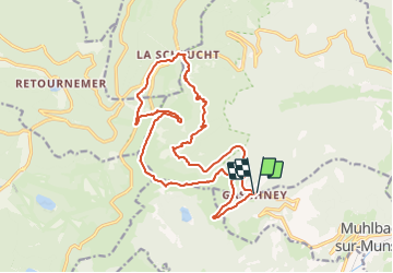
Tocht Te voet van 18,7 km beschikbaar op Grand Est, Haut-Rhin, Stosswihr. Deze tocht wordt voorgesteld door wirth .

Beschrijving

Gaschney - Frankenthal - Col de la Schlucht - Jardin d'altitude - Trois Fours - Col du Falimont - Le Hohneck - Schaefferthal - Hinter Schalleren - FA Schissrothried - Le Gaschney

Hoogteprofiel

Plaatsbepaling

Land:
France
Regio :
Grand Est
Departement/Provincie :
Haut-Rhin
Gemeente :
Stosswihr
Locatie:
Unknown
Vertrek:(UTM)
354438 ; 5322006 (32U) N.

Wandeltochten in de omgeving

Tocht Stappen Le Valtin - Les Rochers des Hirschsteine - Lac Vert - Photo
Stappen
GUIDE
Michel1963

Stappen

Moeilijk
(2)
Le Valtin, Grand Est, Vogezen, France
14,4 km | 22 km-effort
5h 2min
Ja
Tocht Stappen Le Valtin - Le Sentier des Roches - Photo
Stappen
GUIDE
Michel1963

Stappen

Moeilijk
(2)
Le Valtin, Grand Est, Vogezen, France
20 km | 34 km-effort
7h 43min
Ja
Tocht Stappen Stosswihr - Tour du belvedere avec le passage sur les crêtes  - Photo
Stappen
ocepee

Stappen

Heel gemakkelijk
(2)
Stosswihr, Grand Est, Haut-Rhin, France
8,5 km | 0 m-effort
2h 28min
Ja
Tocht Stappen La Bresse - Kastelberg des pierres, des lacs, des panoramas magnifiques  - Photo
Stappen
Alfredy

Stappen

Moeilijk
(1)
La Bresse, Grand Est, Vogezen, France
15,1 km | 26 km-effort
6h 11min
Ja
Tocht Stappen Le Valtin - Les Hirschsteine - Photo
Stappen
VacheKiri67

Stappen

Moeilijk
(1)
Le Valtin, Grand Est, Vogezen, France
16,1 km | 25 km-effort
6h 28min
Ja
Tocht Stappen La Bresse - Du Hohneck au Kastelberg par les Spietzkoepfe et le Sentier des Névées - Photo
Stappen
tracegps

Stappen

Zeer moeilijk
(3)
La Bresse, Grand Est, Vogezen, France
7,6 km | 13,7 km-effort
3h 30min
Ja
Tocht Stappen La Bresse - Rainkopf - Mittlach - Hohneck - Photo
Stappen
tracegps

Stappen

Moeilijk
(1)
La Bresse, Grand Est, Vogezen, France
22 km | 41 km-effort
8h 0min
Ja
Tocht Sneeuwschoenen Le Valtin - raquettes  - Photo
Sneeuwschoenen
vathi54

Sneeuwschoenen

Heel gemakkelijk
(1)
Le Valtin, Grand Est, Vogezen, France
6,6 km | 9,4 km-effort
3h 8min
Neen
Tocht Mountainbike Metzeral - Sentier des Névés - Photo
Mountainbike
tracegps

Mountainbike

Zeer moeilijk
(1)
Metzeral, Grand Est, Haut-Rhin, France
33 km | 52 km-effort
6h 0min
Ja


Sluiten
Mijn abonnementen