![](/images/other/stat-length.png)
![Tocht Stappen Serres-sur-Arget - SERRES Sur ARGET - Photo](https://media.geolcdn.com/t/1900/400/a178165b-4020-47c1-b1aa-022ac0a6feb3.jpg&format=pjpeg&maxdim=2)
SERRES Sur ARGET
RonanDAGORN
Gebruiker
![Lengte](/images/other/stat-length.png)
Lengte
10,6 km
![Max. hoogte](https://static1.geolcdn.com/siteimages/upload/files/1508320355ic_sort_altitude_max_24dp.png)
Max. hoogte
693 m
![Positief hoogteverschil](https://static1.geolcdn.com/siteimages/upload/files/1508320355ic_sort_den_pos_24dp.png)
Positief hoogteverschil
296 m
![Km-Effort](/images/other/stat-length.png)
Km-Effort
14,5 km
![Min. hoogte](https://static1.geolcdn.com/siteimages/upload/files/1508320355ic_sort_altitude_min_24dp.png)
Min. hoogte
490 m
![Negatief hoogteverschil](https://static1.geolcdn.com/siteimages/upload/files/1508320355ic_sort_den_neg_24dp.png)
Negatief hoogteverschil
295 m
![Boucle](https://static1.geolcdn.com/siteimages/upload/files/16400158638029165_repeat_loop_refresh_sync_direction_icon.png)
Boucle
Ja
Datum van aanmaak :
2021-06-04 08:06:02.825
Laatste wijziging :
2021-06-06 09:49:39.248
![Stappen](https://static1.geolcdn.com/sitytour/trail-icons/101.png)
2h48
Moeilijkheid : Medium
![Scan deze QR-code om de tocht te openen in de SityTrail-applicatie](https://capi.geolives.com/qq0zvz2zws4bq2lad0pu/sitytour/trails/2816072/qr.png?size=200)
Gratisgps-wandelapplicatie
Over ons
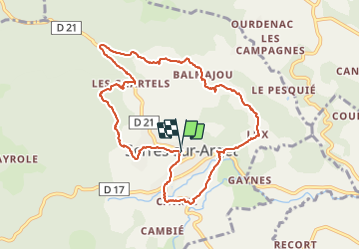
Tocht Stappen van 10,6 km beschikbaar op Occitanië, Ariège, Serres-sur-Arget. Deze tocht wordt voorgesteld door RonanDAGORN.
Beschrijving
Le tour des hameaux.
4 juin 2021
Randonnée assez facile, mais rendue pénible par la végétation non entretenue. Les herbes sont trop hautes et regorgent de tiques.
Tant qu'il n'y aura pas de fauchage, prévoyez de randonner en pantalon et non en short.
Plaatsbepaling
Land:
France
Regio :
Occitanië
Departement/Provincie :
Ariège
Gemeente :
Serres-sur-Arget
Locatie:
Unknown
Vertrek:(Dec)
Vertrek:(UTM)
379214 ; 4758444 (31T) N.
Opmerkingen
Wandeltochten in de omgeving
![Tocht Te voet Brassac - Le Picou depuis Brassac - Photo](https://media.geolcdn.com/t/375/260/22e65925-2aed-45df-a24b-d9dbd1aee596.jpeg&format=jpg&maxdim=2)
![Te voet Te voet](https://static1.geolcdn.com/sitytour/trail-icons/100.png)
Le Picou depuis Brassac
Te voet
Gemakkelijk
Brassac,
Occitanië,
Ariège,
France
![](/images/other/stat-length.png)
5 km | 14,7 km-effort
3h 20min
![](https://static1.geolcdn.com/siteimages/upload/files/16400158638029165_repeat_loop_refresh_sync_direction_icon.png)
Neen
![Tocht Stappen Ganac - cabane des Bladas - Photo](https://media.geolcdn.com/t/375/260/8bd150a0-3aab-453f-8910-10bb01e9a7c9.jpg&format=jpg&maxdim=2)
![Stappen Stappen](https://static1.geolcdn.com/sitytour/trail-icons/101.png)
cabane des Bladas
Stappen
Gemakkelijk
Ganac,
Occitanië,
Ariège,
France
![](/images/other/stat-length.png)
11,8 km | 23 km-effort
7h 0min
![](https://static1.geolcdn.com/siteimages/upload/files/16400158638029165_repeat_loop_refresh_sync_direction_icon.png)
Ja
![Tocht Stappen Brassac - Cabane de la Devèze - Legrillou - Photo](https://media.geolcdn.com/t/375/260/ext.jpg?maxdim=2&url=https%3A%2F%2Fservices.sitytrail.com%2FGeolivesWS%2FDownloadMedia.ashx%3FTrailID%3D129653%26Media%3D13180_1.jpg)
![Stappen Stappen](https://static1.geolcdn.com/sitytour/trail-icons/101.png)
Cabane de la Devèze - Legrillou
Stappen
Gemakkelijk
Brassac,
Occitanië,
Ariège,
France
![](/images/other/stat-length.png)
9,7 km | 17,4 km-effort
1h 30min
![](https://static1.geolcdn.com/siteimages/upload/files/16400158638029165_repeat_loop_refresh_sync_direction_icon.png)
Ja
![Tocht Paard Saint-Pierre-de-Rivière - St Pierre de Rivière - St Martin de Caralp - Photo](https://media.geolcdn.com/t/375/260/ext.jpg?maxdim=2&url=https%3A%2F%2Fservices.sitytrail.com%2FGeolivesWS%2FDownloadMedia.ashx%3FTrailID%3D108265%26Media%3D907_1.jpg)
![Paard Paard](https://static1.geolcdn.com/sitytour/trail-icons/300.png)
St Pierre de Rivière - St Martin de Caralp
Paard
Medium
Saint-Pierre-de-Rivière,
Occitanië,
Ariège,
France
![](/images/other/stat-length.png)
8,9 km | 14 km-effort
1h 0min
![](https://static1.geolcdn.com/siteimages/upload/files/16400158638029165_repeat_loop_refresh_sync_direction_icon.png)
Neen
![Tocht Paard Ganac - Ganac - Le Picou - Photo](https://media.geolcdn.com/t/375/260/ext.jpg?maxdim=2&url=https%3A%2F%2Fservices.sitytrail.com%2FGeolivesWS%2FDownloadMedia.ashx%3FTrailID%3D108260%26Media%3D902_1.jpg)
![Paard Paard](https://static1.geolcdn.com/sitytour/trail-icons/300.png)
Ganac - Le Picou
Paard
Moeilijk
Ganac,
Occitanië,
Ariège,
France
![](/images/other/stat-length.png)
10,4 km | 21 km-effort
1h 30min
![](https://static1.geolcdn.com/siteimages/upload/files/16400158638029165_repeat_loop_refresh_sync_direction_icon.png)
Neen
![Tocht Paard Brassac - Ganac - Col du Calmil - Photo](https://media.geolcdn.com/t/375/260/ext.jpg?maxdim=2&url=https%3A%2F%2Fservices.sitytrail.com%2FGeolivesWS%2FDownloadMedia.ashx%3FTrailID%3D108259%26Media%3D901_1.jpg)
![Paard Paard](https://static1.geolcdn.com/sitytour/trail-icons/300.png)
Ganac - Col du Calmil
Paard
Medium
Brassac,
Occitanië,
Ariège,
France
![](/images/other/stat-length.png)
4,1 km | 6 km-effort
30min
![](https://static1.geolcdn.com/siteimages/upload/files/16400158638029165_repeat_loop_refresh_sync_direction_icon.png)
Neen
![Tocht Paard Serres-sur-Arget - Serres-sur-Arget - La Devèze - Photo](https://media.geolcdn.com/t/375/260/ext.jpg?maxdim=2&url=https%3A%2F%2Fservices.sitytrail.com%2FGeolivesWS%2FDownloadMedia.ashx%3FTrailID%3D108255%26Media%3D897_1.jpg)
![Paard Paard](https://static1.geolcdn.com/sitytour/trail-icons/300.png)
Serres-sur-Arget - La Devèze
Paard
Moeilijk
Serres-sur-Arget,
Occitanië,
Ariège,
France
![](/images/other/stat-length.png)
11,8 km | 22 km-effort
1h 30min
![](https://static1.geolcdn.com/siteimages/upload/files/16400158638029165_repeat_loop_refresh_sync_direction_icon.png)
Neen
![Tocht Paard Brassac - Brassac - La Devèze - Photo](https://media.geolcdn.com/t/375/260/ext.jpg?maxdim=2&url=https%3A%2F%2Fservices.sitytrail.com%2FGeolivesWS%2FDownloadMedia.ashx%3FTrailID%3D108254%26Media%3D896_1.jpg)
![Paard Paard](https://static1.geolcdn.com/sitytour/trail-icons/300.png)
Brassac - La Devèze
Paard
Moeilijk
Brassac,
Occitanië,
Ariège,
France
![](/images/other/stat-length.png)
12,7 km | 26 km-effort
1h 30min
![](https://static1.geolcdn.com/siteimages/upload/files/16400158638029165_repeat_loop_refresh_sync_direction_icon.png)
Neen
![Tocht Stappen Ganac - Ganac - Prat d'Albis - Tour de la Barguillère - Photo](https://media.geolcdn.com/t/375/260/ext.jpg?maxdim=2&url=https%3A%2F%2Fstatic1.geolcdn.com%2Fsiteimages%2Fupload%2Ffiles%2F1553511878bg_sport_marche.png)
![Stappen Stappen](https://static1.geolcdn.com/sitytour/trail-icons/101.png)
Ganac - Prat d'Albis - Tour de la Barguillère
Stappen
Zeer moeilijk
(1)
Ganac,
Occitanië,
Ariège,
France
![](/images/other/stat-length.png)
17,4 km | 33 km-effort
7h 26min
![](https://static1.geolcdn.com/siteimages/upload/files/16400158638029165_repeat_loop_refresh_sync_direction_icon.png)
Ja