![](/images/other/stat-length.png)
![Tocht Stappen Piégut - Tour du ravin de Neyrac Via Piégut - Photo](https://media.geolcdn.com/t/1900/400/f436686e-fd78-43e7-89bc-7db0374b15b6.jpg&format=pjpeg&maxdim=2)
Tour du ravin de Neyrac Via Piégut
PapouBertrand
Gebruiker
![Lengte](/images/other/stat-length.png)
![Max. hoogte](https://static1.geolcdn.com/siteimages/upload/files/1508320355ic_sort_altitude_max_24dp.png)
![Positief hoogteverschil](https://static1.geolcdn.com/siteimages/upload/files/1508320355ic_sort_den_pos_24dp.png)
![Km-Effort](/images/other/stat-length.png)
![Min. hoogte](https://static1.geolcdn.com/siteimages/upload/files/1508320355ic_sort_altitude_min_24dp.png)
![Negatief hoogteverschil](https://static1.geolcdn.com/siteimages/upload/files/1508320355ic_sort_den_neg_24dp.png)
![Boucle](https://static1.geolcdn.com/siteimages/upload/files/16400158638029165_repeat_loop_refresh_sync_direction_icon.png)
![Stappen](https://static1.geolcdn.com/sitytour/trail-icons/101.png)
2h10
Moeilijkheid : Medium
![Scan deze QR-code om de tocht te openen in de SityTrail-applicatie](https://capi.geolives.com/qq0zvz2zws4bq2lad0pu/sitytour/trails/2807699/qr.png?size=200)
Gratisgps-wandelapplicatie
Over ons
Tocht Stappen van 5,7 km beschikbaar op Provence-Alpes-Côte d'Azur, Alpes-de-Haute-Provence, Piégut. Deze tocht wordt voorgesteld door PapouBertrand.
Beschrijving
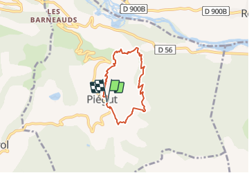
Randonnée Marche de 5,7 km, 2h10 et 430 mètres de dénivelé à découvrir à Piégut, Alpes-de-Haute-Provence, Provence-Alpes-Côte d'Azur. Cette randonnée est proposée par PapouBertrand.
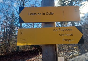
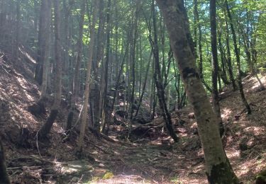
La randonnée peut également démarrer de Neyrac, point bas de la boucle. La rando est assez bien balisée en jaune.
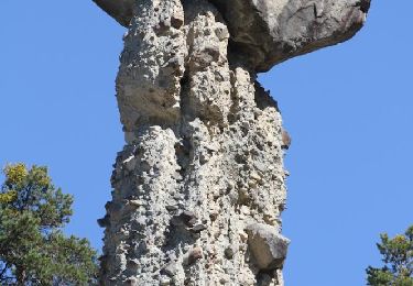
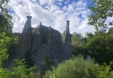
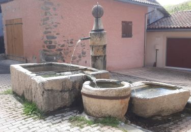
Très belle vue panoramique de la croix du mont Saint Colomban ou il est possible d'écouter un rocher qui parle. Pour entendre le conte, pressez le bouton-poussoir.
Plaatsbepaling
Opmerkingen
Wandeltochten in de omgeving
![Tocht Stappen Théus - R47 Les Demoiselles Coiffees - Photo](https://media.geolcdn.com/t/375/260/ext.jpg?maxdim=2&url=https%3A%2F%2Fservices.sitytrail.com%2FGeolivesWS%2FDownloadMedia.ashx%3FTrailID%3D890906%26Media%3Dc8a3e36a-3aa2-4d75-b341-12feab72a468.jpg)
![Stappen Stappen](https://static1.geolcdn.com/sitytour/trail-icons/101.png)
Stappen
![](/images/other/stat-length.png)
![](https://static1.geolcdn.com/siteimages/upload/files/16400158638029165_repeat_loop_refresh_sync_direction_icon.png)
![Tocht Stappen Théus - Les demoiselles coiffées - Photo](https://media.geolcdn.com/t/375/260/1a3b1ded-039c-4f3a-9433-82de273504ad.jpeg&format=jpg&maxdim=2)
![Stappen Stappen](https://static1.geolcdn.com/sitytour/trail-icons/101.png)
Stappen
![](/images/other/stat-length.png)
![](https://static1.geolcdn.com/siteimages/upload/files/16400158638029165_repeat_loop_refresh_sync_direction_icon.png)
![Tocht Stappen Remollon - Des Demoiselles Coiffées aux balcons de Remollon - Photo](https://media.geolcdn.com/t/375/260/2094a0e8-535c-4f81-bf59-f1f898a15092.jpg&format=jpg&maxdim=2)
![Stappen Stappen](https://static1.geolcdn.com/sitytour/trail-icons/101.png)
Stappen
![](/images/other/stat-length.png)
![](https://static1.geolcdn.com/siteimages/upload/files/16400158638029165_repeat_loop_refresh_sync_direction_icon.png)
![Tocht Stappen Faucon-du-Caire - FAUCON DU CAIRE RAVIN DE L ECHELLE . CRETES DES ROUYERES - Photo](https://media.geolcdn.com/t/375/260/9f83695f-f8d0-4892-a12b-1f657877f2be.jpg&format=jpg&maxdim=2)
![Stappen Stappen](https://static1.geolcdn.com/sitytour/trail-icons/101.png)
Stappen
![](/images/other/stat-length.png)
![](https://static1.geolcdn.com/siteimages/upload/files/16400158638029165_repeat_loop_refresh_sync_direction_icon.png)
![Tocht Stappen Gigors - sabots de venus gigors 860m 12kms - Photo](https://media.geolcdn.com/t/375/260/4376e0fb-d973-434a-abc5-b70530b4e185.jpg&format=jpg&maxdim=2)
![Stappen Stappen](https://static1.geolcdn.com/sitytour/trail-icons/101.png)
Stappen
![](/images/other/stat-length.png)
![](https://static1.geolcdn.com/siteimages/upload/files/16400158638029165_repeat_loop_refresh_sync_direction_icon.png)
![Tocht sport Théus - Mont colombes - Photo](https://media.geolcdn.com/t/375/260/7f8bb3c6-ed1f-4673-837c-336a1770738b.jpg&format=jpg&maxdim=2)
sport
![](/images/other/stat-length.png)
![](https://static1.geolcdn.com/siteimages/upload/files/16400158638029165_repeat_loop_refresh_sync_direction_icon.png)
![Tocht Stappen Théus - J1 2023 - Theus le Mont Colombis - Photo](https://media.geolcdn.com/t/375/260/31ba546d-43eb-4943-a043-7a59d2f6d831.jpg&format=jpg&maxdim=2)
![Stappen Stappen](https://static1.geolcdn.com/sitytour/trail-icons/101.png)
Stappen
![](/images/other/stat-length.png)
![](https://static1.geolcdn.com/siteimages/upload/files/16400158638029165_repeat_loop_refresh_sync_direction_icon.png)
![Tocht Elektrische fiets Remollon - Le Puy et la Chapelle Saint-Sixte Via Remollon (Vélo) - Photo](https://media.geolcdn.com/t/375/260/9848f8cc-dc59-4eb7-862a-9f5bf908e081.jpg&format=jpg&maxdim=2)
![Elektrische fiets Elektrische fiets](https://static1.geolcdn.com/sitytour/trail-icons/205.png)
Elektrische fiets
![](/images/other/stat-length.png)
![](https://static1.geolcdn.com/siteimages/upload/files/16400158638029165_repeat_loop_refresh_sync_direction_icon.png)
![Tocht Elektrische fiets Remollon - VTT-ae - Mont Colombis via Valserres - Croix des prés - Photo](https://media.geolcdn.com/t/375/260/cae6d5f9-a8e8-4077-ab5a-04e6867e007f.jpg&format=jpg&maxdim=2)
![Elektrische fiets Elektrische fiets](https://static1.geolcdn.com/sitytour/trail-icons/205.png)
Elektrische fiets
![](/images/other/stat-length.png)
![](https://static1.geolcdn.com/siteimages/upload/files/16400158638029165_repeat_loop_refresh_sync_direction_icon.png)