


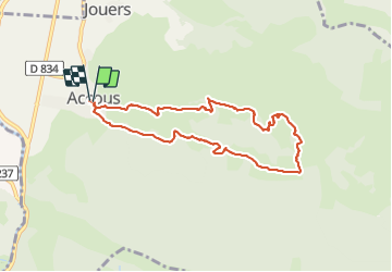


6 km | 8,7 km-effort

Gebruiker GUIDE


Gratisgps-wandelapplicatie
 SityTrail
IGN / Geografische instituten
SityTrail World
De wereld gaat voor u open
Tocht Stappen van 8,8 km beschikbaar op Nieuw-Aquitanië, Pyrénées-Atlantiques, Accous. Deze tocht wordt voorgesteld door marmotte65.
Départ ACCOUS place de l'église et de la mairie. 10h
Compter 2 heures sans se presser jusqu'à la chapelle qui sera le lieu de pique nique et le point culminant de la randonnée .
à la cote 608 sur le retour l'aventure commence .
plusieurs sentiers vont s'offrir à vous . Choisirez celui qui vous paraitra le plus serein et même si quelques passages sont un peu plus raide que la moyenne sachez que tout le monde est passé.
en conclusions une superbe balade appréciée de tous les participants (23) 12 F 11 H pour ce G3 inédit à LPC on reviendra ... mais pas de suite.
2h45 de rando effective plus pause PN encouragement au VTTiste de descente (30 mn) retour voitures à 16h15
le retour aux voitures doit se faire vers 15h45
 "
data-pinterest-text="Pin it"
data-tweet-text="share on twitter"
data-facebook-share-url="https://www.sitytrail.com/nl/trails/2805437-accous--accous-chapelle-san-christau---x2805437x/?photo=1#lg=1&slide=1"
data-twitter-share-url="https://www.sitytrail.com/nl/trails/2805437-accous--accous-chapelle-san-christau---x2805437x/?photo=1#lg=1&slide=1"
data-googleplus-share-url="https://www.sitytrail.com/nl/trails/2805437-accous--accous-chapelle-san-christau---x2805437x/?photo=1#lg=1&slide=1"
data-pinterest-share-url="https://www.sitytrail.com/nl/trails/2805437-accous--accous-chapelle-san-christau---x2805437x/?photo=1#lg=1&slide=1">
"
data-pinterest-text="Pin it"
data-tweet-text="share on twitter"
data-facebook-share-url="https://www.sitytrail.com/nl/trails/2805437-accous--accous-chapelle-san-christau---x2805437x/?photo=1#lg=1&slide=1"
data-twitter-share-url="https://www.sitytrail.com/nl/trails/2805437-accous--accous-chapelle-san-christau---x2805437x/?photo=1#lg=1&slide=1"
data-googleplus-share-url="https://www.sitytrail.com/nl/trails/2805437-accous--accous-chapelle-san-christau---x2805437x/?photo=1#lg=1&slide=1"
data-pinterest-share-url="https://www.sitytrail.com/nl/trails/2805437-accous--accous-chapelle-san-christau---x2805437x/?photo=1#lg=1&slide=1">
 "
data-pinterest-text="Pin it"
data-tweet-text="share on twitter"
data-facebook-share-url="https://www.sitytrail.com/nl/trails/2805437-accous--accous-chapelle-san-christau---x2805437x/?photo=2#lg=1&slide=2"
data-twitter-share-url="https://www.sitytrail.com/nl/trails/2805437-accous--accous-chapelle-san-christau---x2805437x/?photo=2#lg=1&slide=2"
data-googleplus-share-url="https://www.sitytrail.com/nl/trails/2805437-accous--accous-chapelle-san-christau---x2805437x/?photo=2#lg=1&slide=2"
data-pinterest-share-url="https://www.sitytrail.com/nl/trails/2805437-accous--accous-chapelle-san-christau---x2805437x/?photo=2#lg=1&slide=2">
"
data-pinterest-text="Pin it"
data-tweet-text="share on twitter"
data-facebook-share-url="https://www.sitytrail.com/nl/trails/2805437-accous--accous-chapelle-san-christau---x2805437x/?photo=2#lg=1&slide=2"
data-twitter-share-url="https://www.sitytrail.com/nl/trails/2805437-accous--accous-chapelle-san-christau---x2805437x/?photo=2#lg=1&slide=2"
data-googleplus-share-url="https://www.sitytrail.com/nl/trails/2805437-accous--accous-chapelle-san-christau---x2805437x/?photo=2#lg=1&slide=2"
data-pinterest-share-url="https://www.sitytrail.com/nl/trails/2805437-accous--accous-chapelle-san-christau---x2805437x/?photo=2#lg=1&slide=2">
 "
data-pinterest-text="Pin it"
data-tweet-text="share on twitter"
data-facebook-share-url="https://www.sitytrail.com/nl/trails/2805437-accous--accous-chapelle-san-christau---x2805437x/?photo=3#lg=1&slide=3"
data-twitter-share-url="https://www.sitytrail.com/nl/trails/2805437-accous--accous-chapelle-san-christau---x2805437x/?photo=3#lg=1&slide=3"
data-googleplus-share-url="https://www.sitytrail.com/nl/trails/2805437-accous--accous-chapelle-san-christau---x2805437x/?photo=3#lg=1&slide=3"
data-pinterest-share-url="https://www.sitytrail.com/nl/trails/2805437-accous--accous-chapelle-san-christau---x2805437x/?photo=3#lg=1&slide=3">
"
data-pinterest-text="Pin it"
data-tweet-text="share on twitter"
data-facebook-share-url="https://www.sitytrail.com/nl/trails/2805437-accous--accous-chapelle-san-christau---x2805437x/?photo=3#lg=1&slide=3"
data-twitter-share-url="https://www.sitytrail.com/nl/trails/2805437-accous--accous-chapelle-san-christau---x2805437x/?photo=3#lg=1&slide=3"
data-googleplus-share-url="https://www.sitytrail.com/nl/trails/2805437-accous--accous-chapelle-san-christau---x2805437x/?photo=3#lg=1&slide=3"
data-pinterest-share-url="https://www.sitytrail.com/nl/trails/2805437-accous--accous-chapelle-san-christau---x2805437x/?photo=3#lg=1&slide=3">
 "
data-pinterest-text="Pin it"
data-tweet-text="share on twitter"
data-facebook-share-url="https://www.sitytrail.com/nl/trails/2805437-accous--accous-chapelle-san-christau---x2805437x/?photo=4#lg=1&slide=4"
data-twitter-share-url="https://www.sitytrail.com/nl/trails/2805437-accous--accous-chapelle-san-christau---x2805437x/?photo=4#lg=1&slide=4"
data-googleplus-share-url="https://www.sitytrail.com/nl/trails/2805437-accous--accous-chapelle-san-christau---x2805437x/?photo=4#lg=1&slide=4"
data-pinterest-share-url="https://www.sitytrail.com/nl/trails/2805437-accous--accous-chapelle-san-christau---x2805437x/?photo=4#lg=1&slide=4">
"
data-pinterest-text="Pin it"
data-tweet-text="share on twitter"
data-facebook-share-url="https://www.sitytrail.com/nl/trails/2805437-accous--accous-chapelle-san-christau---x2805437x/?photo=4#lg=1&slide=4"
data-twitter-share-url="https://www.sitytrail.com/nl/trails/2805437-accous--accous-chapelle-san-christau---x2805437x/?photo=4#lg=1&slide=4"
data-googleplus-share-url="https://www.sitytrail.com/nl/trails/2805437-accous--accous-chapelle-san-christau---x2805437x/?photo=4#lg=1&slide=4"
data-pinterest-share-url="https://www.sitytrail.com/nl/trails/2805437-accous--accous-chapelle-san-christau---x2805437x/?photo=4#lg=1&slide=4">
 "
data-pinterest-text="Pin it"
data-tweet-text="share on twitter"
data-facebook-share-url="https://www.sitytrail.com/nl/trails/2805437-accous--accous-chapelle-san-christau---x2805437x/?photo=5#lg=1&slide=5"
data-twitter-share-url="https://www.sitytrail.com/nl/trails/2805437-accous--accous-chapelle-san-christau---x2805437x/?photo=5#lg=1&slide=5"
data-googleplus-share-url="https://www.sitytrail.com/nl/trails/2805437-accous--accous-chapelle-san-christau---x2805437x/?photo=5#lg=1&slide=5"
data-pinterest-share-url="https://www.sitytrail.com/nl/trails/2805437-accous--accous-chapelle-san-christau---x2805437x/?photo=5#lg=1&slide=5">
"
data-pinterest-text="Pin it"
data-tweet-text="share on twitter"
data-facebook-share-url="https://www.sitytrail.com/nl/trails/2805437-accous--accous-chapelle-san-christau---x2805437x/?photo=5#lg=1&slide=5"
data-twitter-share-url="https://www.sitytrail.com/nl/trails/2805437-accous--accous-chapelle-san-christau---x2805437x/?photo=5#lg=1&slide=5"
data-googleplus-share-url="https://www.sitytrail.com/nl/trails/2805437-accous--accous-chapelle-san-christau---x2805437x/?photo=5#lg=1&slide=5"
data-pinterest-share-url="https://www.sitytrail.com/nl/trails/2805437-accous--accous-chapelle-san-christau---x2805437x/?photo=5#lg=1&slide=5">
 "
data-pinterest-text="Pin it"
data-tweet-text="share on twitter"
data-facebook-share-url="https://www.sitytrail.com/nl/trails/2805437-accous--accous-chapelle-san-christau---x2805437x/?photo=6#lg=1&slide=6"
data-twitter-share-url="https://www.sitytrail.com/nl/trails/2805437-accous--accous-chapelle-san-christau---x2805437x/?photo=6#lg=1&slide=6"
data-googleplus-share-url="https://www.sitytrail.com/nl/trails/2805437-accous--accous-chapelle-san-christau---x2805437x/?photo=6#lg=1&slide=6"
data-pinterest-share-url="https://www.sitytrail.com/nl/trails/2805437-accous--accous-chapelle-san-christau---x2805437x/?photo=6#lg=1&slide=6">
"
data-pinterest-text="Pin it"
data-tweet-text="share on twitter"
data-facebook-share-url="https://www.sitytrail.com/nl/trails/2805437-accous--accous-chapelle-san-christau---x2805437x/?photo=6#lg=1&slide=6"
data-twitter-share-url="https://www.sitytrail.com/nl/trails/2805437-accous--accous-chapelle-san-christau---x2805437x/?photo=6#lg=1&slide=6"
data-googleplus-share-url="https://www.sitytrail.com/nl/trails/2805437-accous--accous-chapelle-san-christau---x2805437x/?photo=6#lg=1&slide=6"
data-pinterest-share-url="https://www.sitytrail.com/nl/trails/2805437-accous--accous-chapelle-san-christau---x2805437x/?photo=6#lg=1&slide=6">
 "
data-pinterest-text="Pin it"
data-tweet-text="share on twitter"
data-facebook-share-url="https://www.sitytrail.com/nl/trails/2805437-accous--accous-chapelle-san-christau---x2805437x/?photo=7#lg=1&slide=7"
data-twitter-share-url="https://www.sitytrail.com/nl/trails/2805437-accous--accous-chapelle-san-christau---x2805437x/?photo=7#lg=1&slide=7"
data-googleplus-share-url="https://www.sitytrail.com/nl/trails/2805437-accous--accous-chapelle-san-christau---x2805437x/?photo=7#lg=1&slide=7"
data-pinterest-share-url="https://www.sitytrail.com/nl/trails/2805437-accous--accous-chapelle-san-christau---x2805437x/?photo=7#lg=1&slide=7">
"
data-pinterest-text="Pin it"
data-tweet-text="share on twitter"
data-facebook-share-url="https://www.sitytrail.com/nl/trails/2805437-accous--accous-chapelle-san-christau---x2805437x/?photo=7#lg=1&slide=7"
data-twitter-share-url="https://www.sitytrail.com/nl/trails/2805437-accous--accous-chapelle-san-christau---x2805437x/?photo=7#lg=1&slide=7"
data-googleplus-share-url="https://www.sitytrail.com/nl/trails/2805437-accous--accous-chapelle-san-christau---x2805437x/?photo=7#lg=1&slide=7"
data-pinterest-share-url="https://www.sitytrail.com/nl/trails/2805437-accous--accous-chapelle-san-christau---x2805437x/?photo=7#lg=1&slide=7">


Stappen

Stappen

Te voet

Te voet

Te voet

Te voet
Te voet
Te voet

Te voet